MOD09A1.061 Terra Surface Reflectance 8-Day Global 500m
Stay organized with collections
Save and categorize content based on your preferences.
outlined_flag
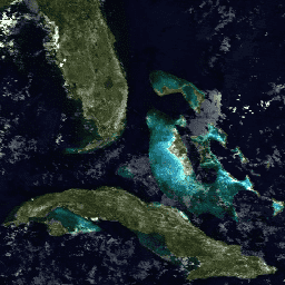
The MOD09A1 V6.1 product provides an estimate of the surface spectral reflectance of Terra MODIS bands 1-7 at 500m resolution, corrected for atmospheric conditions.
This dataset is available from 2000-02-18 to 2025-10-08 and is updated every 8 days.
In addition to seven reflectance bands, the product includes a quality layer and four observation bands.
Pixels are selected for the 8-day composite based on criteria like high observation coverage, low view angle, absence of clouds, and aerosol loading.
Data acquired through the LP DAAC have no restrictions on subsequent use, sale, or redistribution.
Description
The MOD09A1 V6.1 product provides an estimate of the surface
spectral reflectance of Terra MODIS bands 1-7 at 500m resolution
and corrected for atmospheric conditions such as gasses, aerosols,
and Rayleigh scattering. Along with the seven reflectance bands
is a quality layer and four observation bands. For each pixel,
a value is selected from all the acquisitions within the 8-day
composite on the basis of high observation coverage, low view angle,
the absence of clouds or cloud shadow, and aerosol loading.
Documentation:
Bands
Bands
Pixel size: 500 meters (all bands)
Name
Units
Min
Max
Scale
Pixel Size
Wavelength
Description
sur_refl_b01
-100
16000
0.0001
500 meters
620-670nm
Surface reflectance for band 1
sur_refl_b02
-100
16000
0.0001
500 meters
841-876nm
Surface reflectance for band 2
sur_refl_b03
-100
16000
0.0001
500 meters
459-479nm
Surface reflectance for band 3
sur_refl_b04
-100
16000
0.0001
500 meters
545-565nm
Surface reflectance for band 4
sur_refl_b05
-100
16000
0.0001
500 meters
1230-1250nm
Surface reflectance for band 5
sur_refl_b06
-100
16000
0.0001
500 meters
1628-1652nm
Surface reflectance for band 6
sur_refl_b07
-100
16000
0.0001
500 meters
2105-2155nm
Surface reflectance for band 7
QA
500 meters
None
Surface reflectance 500m band quality control flags
Bitmask for QA
Bits 0-1: MODLAND QA bits
0: Corrected product produced at ideal quality - all bands
1: Corrected product produced at less than ideal
quality - some or all bands
2: Corrected product not produced due to cloud effects - all bands
3: Corrected product not produced for other reasons
- some or all bands, may be fill value (11) [Note that
a value of (11) overrides a value of (01)]
Bits 2-5: Band 1 data quality, four bit range
0: Highest quality
7: Noisy detector
8: Dead detector, data interpolated in L1B
9: Solar zenith >= 86 degrees
10: Solar zenith >= 85 and < 86 degrees
11: Missing input
12: Internal constant used in place of climatological
data for at least one atmospheric constant
13: Correction out of bounds, pixel constrained
to extreme allowable value
14: L1B data faulty
15: Not processed due to deep ocean or clouds
Bits 6-9: Band 2 data quality, four bit range
0: Highest quality
7: Noisy detector
8: Dead detector, data interpolated in L1B
9: Solar zenith >= 86 degrees
10: Solar zenith >= 85 and < 86 degrees
11: Missing input
12: Internal constant used in place of climatological
data for at least one atmospheric constant
13: Correction out of bounds, pixel constrained
to extreme allowable value
14: L1B data faulty
15: Not processed due to deep ocean or clouds
Bits 10-13: Band 3 data quality, four bit range
0: Highest quality
7: Noisy detector
8: Dead detector, data interpolated in L1B
9: Solar zenith >= 86 degrees
10: Solar zenith >= 85 and < 86 degrees
11: Missing input
12: Internal constant used in place of climatological
data for at least one atmospheric constant
13: Correction out of bounds, pixel constrained to extreme allowable value
14: L1B data faulty
15: Not processed due to deep ocean or clouds
Bits 14-17: Band 4 data quality, four bit range
0: Highest quality
7: Noisy detector
8: Dead detector, data interpolated in L1B
9: Solar zenith >= 86 degrees
10: Solar zenith >= 85 and < 86 degrees
11: Missing input
12: Internal constant used in place of climatological data for at least one atmospheric constant
13: Correction out of bounds, pixel constrained to extreme allowable value
14: L1B data faulty
15: Not processed due to deep ocean or clouds
Bits 18-21: Band 5 data quality, four bit range
0: Highest quality
7: Noisy detector
8: Dead detector, data interpolated in L1B
9: Solar zenith >= 86 degrees
10: Solar zenith >= 85 and < 86 degrees
11: Missing input
12: Internal constant used in place of climatological data for at least one atmospheric constant
13: Correction out of bounds, pixel constrained to extreme allowable value
14: L1B data faulty
15: Not processed due to deep ocean or clouds
Bits 22-25: Band 6 data quality, four bit range
0: Highest quality
7: Noisy detector
8: Dead detector, data interpolated in L1B
9: Solar zenith >= 86 degrees
10: Solar zenith >= 85 and < 86 degrees
11: Missing input
12: Internal constant used in place of climatological data for at least one atmospheric constant
13: Correction out of bounds, pixel constrained to extreme allowable value
14: L1B data faulty
15: Not processed due to deep ocean or clouds
Bits 26-29: Band 7 data quality, four bit range
0: Highest quality
7: Noisy detector
8: Dead detector, data interpolated in L1B
9: Solar zenith >= 86 degrees
10: Solar zenith >= 85 and < 86 degrees
11: Missing input
12: Internal constant used in place of climatological data for at least one atmospheric constant
13: Correction out of bounds, pixel constrained to extreme allowable value
14: L1B data faulty
15: Not processed due to deep ocean or clouds
Bit 30: Atmospheric correction performed
Bit 31: Adjacency correction performed
SolarZenithdeg
0
18000
0.01
500 meters
None
MODIS Solar zenith angle
ViewZenithdeg
0
18000
0.01
500 meters
None
MODIS view zenith angle
RelativeAzimuthdeg
-18000
18000
0.01
500 meters
None
MODIS relative azimuth angle
StateQA
500 meters
None
Surface reflectance 500m state flags
Bitmask for StateQA
Bits 0-1: Cloud state
0: Clear
1: Cloudy
2: Mixed
3: Not set, assumed clear
Bit 2: Cloud shadow
Bits 3-5: Land/water flag
0: Shallow ocean
1: Land
2: Ocean coastlines and lake shorelines
3: Shallow inland water
4: Ephemeral water
5: Deep inland water
6: Continental/moderate ocean
7: Deep ocean
Bits 6-7: Aerosol quantity
0: Climatology
1: Low
2: Average
3: High
Bits 8-9: Cirrus detected
0: None
1: Small
2: Average
3: High
Bit 10: Internal cloud algorithm flag
Bit 11: Internal fire algorithm flag
Bit 12: MOD35 snow/ice flag
Bit 13: Pixel is adjacent to cloud
Bit 14: BRDF correction performed data
Bit 15: Internal snow mask
DayOfYear
1
366
500 meters
None
Julian day of the year for the pixel
Terms of Use
Terms of Use
MODIS data and products acquired through the LP DAAC
have no restrictions on subsequent use, sale, or redistribution.
Explore with Earth Engine
Important:
Earth Engine is a platform for petabyte-scale scientific analysis and visualization of
geospatial datasets, both for public benefit and for business and government users.
Earth Engine is free to use for research, education, and nonprofit use. To get started, please
register for Earth Engine access.
Code Editor (JavaScript)
var dataset = ee . ImageCollection ( 'MODIS/061/MOD09A1' )
. filter ( ee . Filter . date ( '2018-01-01' , '2018-05-01' ));
var trueColor =
dataset . select ([ 'sur_refl_b01' , 'sur_refl_b04' , 'sur_refl_b03' ]);
var trueColorVis = {
min : - 100.0 ,
max : 3000.0 ,
};
Map . setCenter ( 6.746 , 46.529 , 6 );
Map . addLayer ( trueColor , trueColorVis , 'True Color' );
Python setup
See the
Python Environment page for information on the Python API and using
geemap for interactive development.
import ee
import geemap.core as geemap
Colab (Python)
dataset = ee . ImageCollection ( 'MODIS/061/MOD09A1' ) . filter (
ee . Filter . date ( '2018-01-01' , '2018-05-01' )
)
true_color = dataset . select ([ 'sur_refl_b01' , 'sur_refl_b04' , 'sur_refl_b03' ])
true_color_vis = { 'min' : - 100.0 , 'max' : 3000.0 }
m = geemap . Map ()
m . set_center ( 6.746 , 46.529 , 6 )
m . add_layer ( true_color , true_color_vis , 'True Color' )
m
Open in Code Editor
[null,null,[],[],["The MOD09A1 V6.1 dataset from NASA LP DAAC/USGS EROS Center provides Terra MODIS surface spectral reflectance data across seven bands (500m resolution) from 2000-02-18 to 2025-02-10, with an 8-day cadence. It includes atmospheric corrections and selects pixel values based on high observation coverage, low view angle, and minimal cloud or aerosol presence. The dataset has a quality layer and four observation bands, and it's available in Google Earth Engine using `ee.ImageCollection(\"MODIS/061/MOD09A1\")`.\n"]]