- Disponibilidad del conjunto de datos
- 1981-07-01T00:00:00Z–2013-12-16T00:00:00Z
- Proveedor del conjunto de datos
- NASA/NOAA
- Cadencia
- 15 días
- Etiquetas
Descripción
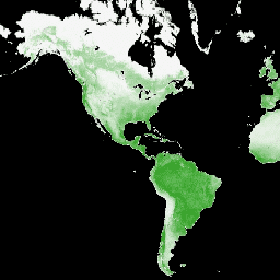
El NDVI de GIMMS se genera a partir de varios sensores AVHRR de la NOAA para una cuadrícula global de latitud y longitud de 1/12 de grado. La versión más reciente del conjunto de datos del NDVI de GIMMS se denomina NDVI3g (NDVI de GIMMS de tercera generación a partir de sensores AVHRR).
Bandas
Bandas
Tamaño de píxel: 9,277 metros (todas las bandas)
| Nombre | Mín. | Máx. | Tamaño de los píxeles | Descripción | |||||||||||||||||||||||||||||||||||||||||||||||||||||||||||||||||||||||||||||||||||||||||||||||
|---|---|---|---|---|---|---|---|---|---|---|---|---|---|---|---|---|---|---|---|---|---|---|---|---|---|---|---|---|---|---|---|---|---|---|---|---|---|---|---|---|---|---|---|---|---|---|---|---|---|---|---|---|---|---|---|---|---|---|---|---|---|---|---|---|---|---|---|---|---|---|---|---|---|---|---|---|---|---|---|---|---|---|---|---|---|---|---|---|---|---|---|---|---|---|---|---|---|---|---|
ndvi |
-1 | 1 | 9277 metros | NDVI |
|||||||||||||||||||||||||||||||||||||||||||||||||||||||||||||||||||||||||||||||||||||||||||||||
qa |
9277 metros | Marca de QA |
|||||||||||||||||||||||||||||||||||||||||||||||||||||||||||||||||||||||||||||||||||||||||||||||||
Condiciones de Uso
Condiciones de Uso
Este conjunto de datos es de dominio público y está disponible sin restricciones de uso ni distribución. Consulta la Política de datos e información de ciencias de la Tierra de la NASA para obtener más información.
Explora con Earth Engine
Editor de código (JavaScript)
var dataset = ee.ImageCollection('NASA/GIMMS/3GV0')
                  .filter(ee.Filter.date('2013-06-01', '2013-12-31'));
var ndvi = dataset.select('ndvi');
var ndviVis = {
  min: -1.0,
  max: 1.0,
  palette: ['000000', 'f5f5f5', '119701'],
};
Map.setCenter(-88.6, 26.4, 1);
Map.addLayer(ndvi, ndviVis, 'NDVI');