- در دسترس بودن مجموعه دادهها
- 2013-04-11T00:00:00Z–2026-06-06T23:59:42Z
- تولیدکننده مجموعه داده
- ناسا الپی دیایایسی
- برچسبها
توضیحات
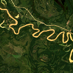
پروژه هماهنگشده لندست سنتینل-۲ (HLS) دادههای بازتاب سطحی (SR) و روشنایی بالای جو (TOA) ثابتی را از یک مجموعه مجازی از حسگرهای ماهوارهای ارائه میدهد. تصویرگر عملیاتی زمین (OLI) بر روی ماهوارههای مشترک ناسا/USGS لندست ۸ و لندست ۹ قرار دارد، در حالی که ابزار چند طیفی (MSI) بر روی ماهوارههای کوپرنیک سنتینل-۲A و سنتینل-۲B اروپا نصب شده است. اندازهگیری ترکیبی، مشاهدات جهانی از زمین را هر ۲ تا ۳ روز یکبار با وضوح مکانی ۳۰ متر امکانپذیر میکند. پروژه HLS از مجموعهای از الگوریتمها برای به دست آوردن محصولات یکپارچه از OLI و MSI استفاده میکند که شامل تصحیح جوی، پوشش ابر و سایه ابر، ثبت همزمان مکانی و شبکهبندی مشترک، نرمالسازی زاویه روشنایی و دید و تنظیم پهنای باند طیفی است.
پروژه HLS دادهها را به صورت دو محصول جداگانه توزیع میکند: HLSL30 (لندست ۸/۹) و HLSS30 (سنتینل-۲ A/B). هر دوی آنها تابع توزیع بازتاب دو جهته نادیر ۳۰ متری (BRDF) و بازتاب تعدیلشده (NBAR) را ارائه میدهند.
مستندات:
لینک کاتالوگ S30: NASA/HLS/HLSS30/v002
باندها
باندها
اندازه پیکسل: 30 متر (همه باندها)
| نام | واحدها | اندازه پیکسل | توضیحات | ||||||||||||||||||||||||||||||||||||||||||||||||||||||||||||||||||||||||||||||||||||||||||||||||
|---|---|---|---|---|---|---|---|---|---|---|---|---|---|---|---|---|---|---|---|---|---|---|---|---|---|---|---|---|---|---|---|---|---|---|---|---|---|---|---|---|---|---|---|---|---|---|---|---|---|---|---|---|---|---|---|---|---|---|---|---|---|---|---|---|---|---|---|---|---|---|---|---|---|---|---|---|---|---|---|---|---|---|---|---|---|---|---|---|---|---|---|---|---|---|---|---|---|---|---|
B1 | ۳۰ متر | آئروسل ساحلی | |||||||||||||||||||||||||||||||||||||||||||||||||||||||||||||||||||||||||||||||||||||||||||||||||
B2 | ۳۰ متر | آبی | |||||||||||||||||||||||||||||||||||||||||||||||||||||||||||||||||||||||||||||||||||||||||||||||||
B3 | ۳۰ متر | سبز | |||||||||||||||||||||||||||||||||||||||||||||||||||||||||||||||||||||||||||||||||||||||||||||||||
B4 | ۳۰ متر | قرمز | |||||||||||||||||||||||||||||||||||||||||||||||||||||||||||||||||||||||||||||||||||||||||||||||||
B5 | ۳۰ متر | نیر | |||||||||||||||||||||||||||||||||||||||||||||||||||||||||||||||||||||||||||||||||||||||||||||||||
B6 | ۳۰ متر | SWIR1 | |||||||||||||||||||||||||||||||||||||||||||||||||||||||||||||||||||||||||||||||||||||||||||||||||
B7 | ۳۰ متر | SWIR2 | |||||||||||||||||||||||||||||||||||||||||||||||||||||||||||||||||||||||||||||||||||||||||||||||||
B9 | ۳۰ متر | سیروس | |||||||||||||||||||||||||||||||||||||||||||||||||||||||||||||||||||||||||||||||||||||||||||||||||
B10 | ۳۰ متر | تیرس۱ | |||||||||||||||||||||||||||||||||||||||||||||||||||||||||||||||||||||||||||||||||||||||||||||||||
B11 | ۳۰ متر | تیرس۲ | |||||||||||||||||||||||||||||||||||||||||||||||||||||||||||||||||||||||||||||||||||||||||||||||||
Fmask | ۳۰ متر | بیتهای باکیفیت | |||||||||||||||||||||||||||||||||||||||||||||||||||||||||||||||||||||||||||||||||||||||||||||||||
SZA | درجه | ۳۰ متر | زاویه سمت الراس خورشید | ||||||||||||||||||||||||||||||||||||||||||||||||||||||||||||||||||||||||||||||||||||||||||||||||
SAA | درجه | ۳۰ متر | زاویه آزیموت خورشید | ||||||||||||||||||||||||||||||||||||||||||||||||||||||||||||||||||||||||||||||||||||||||||||||||
VZA | درجه | ۳۰ متر | زاویه دید زنیت را مشاهده کنید | ||||||||||||||||||||||||||||||||||||||||||||||||||||||||||||||||||||||||||||||||||||||||||||||||
VAA | درجه | ۳۰ متر | زاویه آزیموت را مشاهده کنید | ||||||||||||||||||||||||||||||||||||||||||||||||||||||||||||||||||||||||||||||||||||||||||||||||
ویژگیهای تصویر
ویژگیهای تصویر
| نام | نوع | توضیحات |
|---|---|---|
| آکورد | رشته | نسخه LaSRC، مثلاً LaSRCS2AV3.5.5 یا LaSRCL8V3.5.5 |
| شناسه محصول LANDSAT | رشته | شناسه محصول صحنه L1 ورودی لندست-۸ برای پردازش ردیابی معکوس. |
| مدل TIRS | رشته | مدل موقعیت انکودر TIRS SSM (مقدماتی، نهایی یا واقعی). |
| وضعیت موقعیت TIRS | رشته | ال۳۰ |
| نرمافزار USGS | رشته | LPGS_2.6.2 |
| پوشش ابری | دو برابر | درصد ابر و سایه ابر در مشاهدات بر اساس Fmask |
| زمان پردازش HLS | رشته | تاریخ و زمان پردازش HLS برای این مشاهده |
| زاویه سمت خورشید میانگین | دو برابر | میانگین زاویه سمت خورشید بر حسب درجه در دادههای ورودی برای HLS L30 |
| زاویه_سمت_بالا_میانگین_خورشید | دو برابر | میانگین زاویه اوج خورشید بر حسب درجه در دادههای ورودی برای HLS L30 |
| زاویه دید عمودی میانگین | دو برابر | زاویه آزیموت نمای میانگین بر حسب درجه از دادههای ورودی |
| زاویه دید عمودی | دو برابر | زاویه اوج نمای میانگین بر حسب درجه داده ورودی |
| NBAR_SOLAR_ZENITH | دو برابر | زاویه اوج خورشیدی مورد استفاده در استخراج NBAR |
| پوشش_فضایی | دو برابر | درصد کاشی با داده |
شرایط استفاده
شرایط استفاده
ناسا اشتراکگذاری کامل و آزاد تمام دادهها را با جوامع تحقیقاتی و کاربردی، صنایع خصوصی، دانشگاهها و عموم مردم ترویج میدهد.
نقل قولها
ماسک، جی.، جو، جی.، راجر، جی.، اسکاکون، اس.، ورموت، ای.، کلاوری، ام.، دانگان، جی.، یین، زی.، فریتاگ، بی.، جاستیس، سی. (2021). بازتاب سطحی تصویرگر عملیاتی زمین HLS و روشنایی روزانه جهانی TOA 30 متر نسخه 2.0 [مجموعه داده]. مرکز بایگانی فعال توزیعشده فرآیندهای زمینی ناسا EOSDIS. دسترسی در تاریخ 2023-09-12 از https://doi.org/10.5067/HLS/HLSL30.002
DOI ها
با موتور زمین کاوش کنید
ویرایشگر کد (جاوااسکریپت)
var collection = ee.ImageCollection("NASA/HLS/HLSL30/v002")
                    .filter(ee.Filter.date('2013-04-25', '2013-04-28'))
                    .filter(ee.Filter.lt('CLOUD_COVERAGE', 30));
var visParams = {
  bands: ['B4', 'B3', 'B2'],
  min:0.01,
  max:0.18,
};

var visualizeImage = function(image) {
  var imageRGB = image.visualize(visParams);
  return imageRGB;
};

var rgbCollection = collection.map(visualizeImage);

Map.setCenter(-60.1765, -22.5318, 11)
Map.addLayer(rgbCollection, {}, 'HLS RGB bands');