O conjunto de dados de temperatura da superfície do mar (WHOI) faz parte do pacote de superfície oceânica (OSB) da NOAA e fornece um registro de dados climáticos (CDR) de alta qualidade da temperatura da superfície do mar em oceanos sem gelo.
Os valores de SST são encontrados modelando a variabilidade diurna em combinação com observações de temperatura da superfície do mar do AVHRR.
Bandas
Tamanho do pixel 27830 metros
Bandas
Nome
Unidades
Mín.
Máx.
Tamanho do pixel
Descrição
sea_surface_temperature
°C
-1,79*
35*
metros
Temperatura da superfície do mar por interpolação ideal (OISST, na sigla em inglês), com uma correção de aquecimento diurno
fill_missing_qc
metros
Flags de controle de qualidade
Máscara de bits para "fill_missing_qc"
Bits 0 a 2: flags de controle de qualidade
0: valores de pixels da rede neural
1: flag não usada
2: Neve/gelo
3: Sobre a terra
4: Sobre o lago
5: SST ausente, SST não resolvido
* valor mínimo ou máximo estimado
Termos de Uso
Termos de Uso
O ponto de distribuição oficial do Programa de CDR da NOAA é o Centro Nacional de Dados Climáticos da NOAA, que oferece acesso aberto e sustentado e gerenciamento ativo de dados dos pacotes de CDR e informações relacionadas, de acordo com as políticas e práticas de dados abertos dos Estados Unidos, conforme descrito no Memorando do Presidente sobre "Política de dados abertos" e de acordo com a Ordem Executiva de 9 de maio de 2013, "Tornar abertos e legíveis por máquina o novo padrão para informações governamentais". De acordo com essas políticas, os conjuntos de dados de CDR não são proprietários, estão disponíveis publicamente e não têm restrições de uso. Para mais informações, consulte o PDF
Uso justo de conjuntos de dados, algoritmos e documentação do CDR da NOAA.
Citações
Citações:
Clayson, Carol Anne, Brown, Jeremiah, and NOAA CDR Program (2016). Registro de dados climáticos da NOAA, pacote de superfície oceânica (OSB), registro de dados climáticos (CDR) de temperatura da superfície do mar - WHOI, versão 2. [indique o subconjunto usado]. NOAA
National Climatic Data Center. doi:10.7289/V5FB510W.
O conjunto de dados de temperatura da superfície do mar (WHOI) faz parte do pacote de superfície oceânica (OSB, na sigla em inglês) da NOAA e fornece um registro de dados climáticos (CDR, na sigla em inglês) de alta qualidade da temperatura da superfície do mar em oceanos sem gelo. Os valores de SST são encontrados modelando a variabilidade diurna em combinação com observações do AVHRR da superfície do mar…
[null,null,[],[[["\u003cp\u003eThe NOAA CDR SST_WHOI/V2 dataset provides a Climate Data Record (CDR) of sea surface temperature over ice-free oceans from 1988 to 2021.\u003c/p\u003e\n"],["\u003cp\u003eThe dataset utilizes a diurnal warming correction model combined with AVHRR observations to derive sea surface temperature values.\u003c/p\u003e\n"],["\u003cp\u003eIt offers global coverage at a 27830-meter resolution and includes quality control flags for data reliability.\u003c/p\u003e\n"],["\u003cp\u003eThis dataset is freely available for research, education, and non-profit use through the Google Earth Engine platform.\u003c/p\u003e\n"],["\u003cp\u003eNOAA's National Climatic Data Center is the official source and distributor, ensuring open access and data management in accordance with US open data policies.\u003c/p\u003e\n"]]],["The NOAA Sea Surface Temperature - WHOI dataset, available from 1988 to 2021 at a 3-hour cadence, provides sea surface temperature (SST) data over ice-free oceans, with diurnal variability modeling and AVHRR observations. The dataset, part of NOAA's Ocean Surface Bundle, offers quality-controlled SST values in Celsius, with pixel sizes of 27830 meters. It can be accessed via Google Earth Engine, using the `ee.ImageCollection(\"NOAA/CDR/SST_WHOI/V2\")` snippet.\n"],null,["# NOAA CDR WHOI: Sea Surface Temperature, Version 2\n\nDataset Availability\n: 1988-01-01T00:00:00Z--2021-08-31T00:00:00Z\n\nDataset Provider\n:\n\n\n [NOAA](https://www.ncei.noaa.gov/products/climate-data-records/sea-surface-temperature-whoi)\n\nCadence\n: 3 Hours\n\nTags\n:\n [atmospheric](/earth-engine/datasets/tags/atmospheric) [cdr](/earth-engine/datasets/tags/cdr) [hourly](/earth-engine/datasets/tags/hourly) [noaa](/earth-engine/datasets/tags/noaa) [ocean](/earth-engine/datasets/tags/ocean) [oceans](/earth-engine/datasets/tags/oceans) [oisst](/earth-engine/datasets/tags/oisst) [osb](/earth-engine/datasets/tags/osb) [sst](/earth-engine/datasets/tags/sst) \nwhoi \n\n#### Description\n\nThe Sea Surface Temperature - WHOI dataset is part of the NOAA Ocean Surface\nBundle (OSB) and provides a high quality Climate Data Record (CDR) of sea\nsurface temperature over ice-free oceans.\n\nThe SST values are found through modeling the diurnal variability in\ncombination with AVHRR observations of sea surface temperature.\n\n### Bands\n\n\n**Pixel Size**\n\n27830 meters\n\n**Bands**\n\n| Name | Units | Min | Max | Pixel Size | Description |\n|---------------------------|-------|---------|------|------------|------------------------------------------------------------------------------------------|---|---|---|---|---|---|---|---|---|---|---|---|---|---|---|---|---|---|---|---|---|---|---|---|---|---|---|---|---|---|---|---|---|---|---|---|---|---|---|---|---|---|---|---|---|---|---|---|---|---|---|---|---|---|---|---|---|---|---|---|---|---|---|---|---|---|---|---|---|---|---|---|---|---|---|---|---|---|---|---|---|---|---|---|---|---|---|---|---|---|---|---|---|---|\n| `sea_surface_temperature` | °C | -1.79\\* | 35\\* | meters | Optimum Interpolation Sea Surface Temperature (OISST), with a diurnal warming correction |\n| `fill_missing_qc` | | | | meters | Quality control flags |\n| Bitmask for fill_missing_qc - Bits 0-2: Quality control flags - 0: Pixel values from neural network - 1: Unused flag - 2: Snow/ice - 3: Over land - 4: Over lake - 5: SST missing, SST unresolved ||||||||||||||||||||||||||||||||||||||||||||||||||||||||||||||||||||||||||||||||||||||||||||||||||||\n\n\\* estimated min or max value\n\n### Terms of Use\n\n**Terms of Use**\n\nThe NOAA CDR Program's official distribution point for CDRs is NOAA's\nNational Climatic Data Center which provides sustained, open access and\nactive data management of the CDR packages and related information in\nkeeping with the United States' open data policies and practices as\ndescribed in the President's Memorandum on \"Open Data Policy\" and pursuant\nto the Executive Order of May 9, 2013, \"Making Open and Machine Readable\nthe New Default for Government Information\". In line with these policies,\nthe CDR data sets are nonproprietary, publicly available, and no\nrestrictions are placed upon their use. For more information, see the\n[Fair Use of NOAA's CDR Data Sets, Algorithms and Documentation](https://www1.ncdc.noaa.gov/pub/data/sds/cdr/CDRs/Aerosol_Optical_Thickness/UseAgreement_01B-04.pdf)\npdf.\n\n### Citations\n\nCitations:\n\n- Clayson, Carol Anne, Brown, Jeremiah, and NOAA CDR Program (2016). NOAA\n Climate Data Record Ocean Surface Bundle (OSB) Climate Data Record (CDR) of\n Sea Surface Temperature - WHOI, Version 2. \\[indicate subset used\\]. NOAA\n National Climatic Data Center. [doi:10.7289/V5FB510W](https://doi.org/10.7289/V5FB510W).\n\n### DOIs\n\n- \u003chttps://doi.org/10.7289/V5FB510W\u003e\n\n### Explore with Earth Engine\n\n| **Important:** Earth Engine is a platform for petabyte-scale scientific analysis and visualization of geospatial datasets, both for public benefit and for business and government users. Earth Engine is free to use for research, education, and nonprofit use. To get started, please [register for Earth Engine access.](https://console.cloud.google.com/earth-engine)\n\n### Code Editor (JavaScript)\n\n```javascript\n
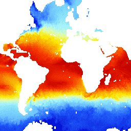
var dataset = ee.ImageCollection('NOAA/CDR/SST_WHOI/V2')\n .filter(ee.Filter.date('2018-03-01', '2018-03-14'));\nvar seaSurfaceTemperature = dataset.select('sea_surface_temperature');\nvar visParams = {\n min: 0.0,\n max: 30.0,\n palette: [\n '040274', '040281', '0502a3', '0502b8', '0502ce', '0502e6',\n '0602ff', '235cb1', '307ef3', '269db1', '30c8e2', '32d3ef',\n '3be285', '3ff38f', '86e26f', '3ae237', 'b5e22e', 'd6e21f',\n 'fff705', 'ffd611', 'ffb613', 'ff8b13', 'ff6e08', 'ff500d',\n 'ff0000', 'de0101', 'c21301', 'a71001', '911003'\n ],\n};\nMap.setCenter(-4.92, -21.09, 2);\nMap.addLayer(seaSurfaceTemperature, visParams, 'Sea Surface Temperature');\n```\n[Open in Code Editor](https://code.earthengine.google.com/?scriptPath=Examples:Datasets/NOAA/NOAA_CDR_SST_WHOI_V2) \n[NOAA CDR WHOI: Sea Surface Temperature, Version 2](/earth-engine/datasets/catalog/NOAA_CDR_SST_WHOI_V2) \nThe Sea Surface Temperature - WHOI dataset is part of the NOAA Ocean Surface Bundle (OSB) and provides a high quality Climate Data Record (CDR) of sea surface temperature over ice-free oceans. The SST values are found through modeling the diurnal variability in combination with AVHRR observations of sea surface ... \nNOAA/CDR/SST_WHOI/V2, atmospheric,cdr,hourly,noaa,ocean,oceans,oisst,osb,sst \n1988-01-01T00:00:00Z/2021-08-31T00:00:00Z \n-90 -180 90 180 \nGoogle Earth Engine \nhttps://developers.google.com/earth-engine/datasets\n\n- [https://doi.org/10.7289/V5FB510W](https://doi.org/https://www.ncei.noaa.gov/products/climate-data-records/sea-surface-temperature-whoi)\n- [https://doi.org/10.7289/V5FB510W](https://doi.org/https://developers.google.com/earth-engine/datasets/catalog/NOAA_CDR_SST_WHOI_V2)"]]