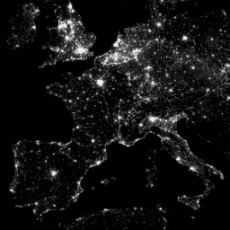
국방 기상 프로그램 (DMSP) 운영 라인 스캔 시스템(OLS)은 밤에 가시광선 및 근적외선 (VNIR) 방출 소스를 감지하는 고유한 기능을 갖추고 있습니다.
이 컬렉션에는 센서 포화가 없는 전역 야간 조명 이미지가 포함되어 있습니다. 센서는 일반적으로 달빛이 비치는 구름을 감지할 수 있도록 높은 게인 설정으로 작동합니다. 하지만 6비트 양자화와 제한된 동적 범위로 인해 기록된 데이터는 도시 중심부의 밝은 코어에서 포화됩니다. 탐지기의 게인이 일반적인 작동 설정보다 훨씬 낮게 설정된 (때로는 100배) 낮은 달 조명에서 제한된 관측 세트가 획득되었습니다. 낮은 게인 설정에서 획득한 스파스 데이터는 높은 게인 설정에서 획득한 운영 데이터와 결합되어 센서 포화가 없는 전역 야간 조명 이미지 세트를 생성했습니다. 최대 범위를 확보하기 위해 서로 다른 위성의 데이터가 최종 제품으로 병합되고 혼합되었습니다. 자세한 내용은 제공업체의 이 리드미 파일을 참고하세요.
NOAA의 National Geophysical Data Center에서 이미지와 데이터를 처리합니다.
미국 공군 기상청에서 수집한 DMSP 데이터입니다.
대역
픽셀 크기 927.67미터
대역
이름
최소
최대
픽셀 크기
설명
avg_vis
0*
6060.6*
미터
구름이 없는 빛 감지 관측의 평균 디지털 밴드 번호입니다.
cf_cvg
0*
175*
미터
구름이 없는 커버리지, 각 30초 그리드 셀에 포함된 총 관측 수입니다. 이 이미지를 사용하여 품질이 저하된 관측 수가 적은 영역을 식별할 수 있습니다.
* 예상 최솟값 또는 최댓값
이용약관
이용약관
NOAA 데이터, 정보, 제품은 전송 방법에 관계없이 저작권이 적용되지 않으며 일반인의 후속 사용에 제한이 없습니다. 획득한 후에는 합법적인 용도로 사용할 수 있습니다. 위의 데이터는 퍼블릭 도메인에 속하며 사용 및 배포에 제한 없이 제공됩니다.
국방 기상 프로그램 (DMSP) 운영 라인 스캔 시스템 (OLS)은 야간에 가시광선 및 근적외선 (VNIR) 방출원을 감지하는 고유한 기능을 갖추고 있습니다. 이 컬렉션에는 센서 포화가 없는 전역 야간 조명 이미지가 포함되어 있습니다. 센서는 일반적으로 달빛이 비치는 구름을 감지할 수 있도록 게인 설정이 높게 작동합니다. …
[null,null,[],[[["\u003cp\u003eThe NOAA/DMSP-OLS/CALIBRATED_LIGHTS_V4 dataset provides global nighttime lights images with no sensor saturation, covering 1996 to 2011.\u003c/p\u003e\n"],["\u003cp\u003eIt utilizes data from the Defense Meteorological Program (DMSP) Operational Line-Scan System (OLS) to detect visible and near-infrared emissions at night.\u003c/p\u003e\n"],["\u003cp\u003eThe dataset includes two bands: 'avg_vis' representing average visible light and 'cf_cvg' indicating cloud-free coverage.\u003c/p\u003e\n"],["\u003cp\u003eImages are at a 30 arc second resolution, which is approximately 927 meters.\u003c/p\u003e\n"],["\u003cp\u003eThe data is in the public domain and freely available for use and distribution without restriction.\u003c/p\u003e\n"]]],[],null,["# DMSP OLS: Global Radiance-Calibrated Nighttime Lights Version 4, Defense Meteorological Program Operational Linescan System\n\nDataset Availability\n: 1996-03-16T00:00:00Z--2011-07-31T00:00:00Z\n\nDataset Provider\n:\n\n\n [Earth Observation Group, Payne Institute for Public Policy, Colorado School of Mines](https://eogdata.mines.edu/dmsp/download_radcal.html)\n\nTags\n:\n [dmsp](/earth-engine/datasets/tags/dmsp) [eog](/earth-engine/datasets/tags/eog) [imagery](/earth-engine/datasets/tags/imagery) [lights](/earth-engine/datasets/tags/lights) [nighttime](/earth-engine/datasets/tags/nighttime) [ols](/earth-engine/datasets/tags/ols) [population](/earth-engine/datasets/tags/population) [radiance](/earth-engine/datasets/tags/radiance) [visible](/earth-engine/datasets/tags/visible) [yearly](/earth-engine/datasets/tags/yearly) \ncalibrated \n\n#### Description\n\nThe Defense Meteorological Program (DMSP) Operational Line-Scan System\n(OLS) has a unique capability to detect visible and near-infrared (VNIR)\nemission sources at night.\n\nThis collection contains global nighttime lights images with no sensor\nsaturation. The sensor is typically operated at a high-gain setting to\nenable the detection of moonlit clouds. However, with six bit quantization\nand limited dynamic range, the recorded data are saturated in the bright\ncores of urban centers. A limited set of observations at low lunar\nillumination were obtained where the gain of the detector was set\nsignificantly lower than its typical operational setting (sometimes by a\nfactor of 100). Sparse data acquired at low-gain settings were combined\nwith the operational data acquired at high-gain settings to produce the set\nof global nighttime lights images with no sensor saturation. Data from\ndifferent satellites were merged and blended into the final product in order\nto gain maximum coverage. For more information, see this\n[readme](https://eogdata.mines.edu/dmsp/radcal_readme.txt)\nfile from the provider.\n\nImage and data processing by NOAA's National Geophysical Data Center.\nDMSP data collected by US Air Force Weather Agency.\n\n### Bands\n\n\n**Pixel Size**\n\n927.67 meters\n\n**Bands**\n\n| Name | Min | Max | Pixel Size | Description |\n|-----------|-----|----------|------------|-------------------------------------------------------------------------------------------------------------------------------------------------------------------------------------------------------------|\n| `avg_vis` | 0\\* | 6060.6\\* | meters | Average digital band numbers from observations with cloud-free light detection. |\n| `cf_cvg` | 0\\* | 175\\* | meters | Cloud-free coverages, the total number of observations that went into each 30-arc second grid cell. This image can be used to identify areas with low numbers of observations where the quality is reduced. |\n\n\\* estimated min or max value\n\n### Terms of Use\n\n**Terms of Use**\n\nNOAA data, information, and products, regardless of the method of delivery,\nare not subject to copyright and carry no restrictions on their subsequent\nuse by the public. Once obtained, they may be put to any lawful use. The\nforgoing data is in the public domain and is being provided without\nrestriction on use and distribution.\n\n### Explore with Earth Engine\n\n| **Important:** Earth Engine is a platform for petabyte-scale scientific analysis and visualization of geospatial datasets, both for public benefit and for business and government users. Earth Engine is free to use for research, education, and nonprofit use. To get started, please [register for Earth Engine access.](https://console.cloud.google.com/earth-engine)\n\n### Code Editor (JavaScript)\n\n```javascript\nvar dataset = ee.ImageCollection('NOAA/DMSP-OLS/CALIBRATED_LIGHTS_V4')\n .filter(ee.Filter.date('2010-01-01', '2010-12-31'));\nvar nighttimeLights = dataset.select('avg_vis');\nvar nighttimeLightsVis = {\n min: 3.0,\n max: 60.0,\n};\nMap.setCenter(7.82, 49.1, 4);\nMap.addLayer(nighttimeLights, nighttimeLightsVis, 'Nighttime Lights');\n```\n[Open in Code Editor](https://code.earthengine.google.com/?scriptPath=Examples:Datasets/NOAA/NOAA_DMSP-OLS_CALIBRATED_LIGHTS_V4) \n[DMSP OLS: Global Radiance-Calibrated Nighttime Lights Version 4, Defense Meteorological Program Operational Linescan System](/earth-engine/datasets/catalog/NOAA_DMSP-OLS_CALIBRATED_LIGHTS_V4) \nThe Defense Meteorological Program (DMSP) Operational Line-Scan System (OLS) has a unique capability to detect visible and near-infrared (VNIR) emission sources at night. This collection contains global nighttime lights images with no sensor saturation. The sensor is typically operated at a high-gain setting to enable the detection of moonlit clouds. ... \nNOAA/DMSP-OLS/CALIBRATED_LIGHTS_V4, dmsp,eog,imagery,lights,nighttime,ols,population,radiance,visible,yearly \n1996-03-16T00:00:00Z/2011-07-31T00:00:00Z \n-65 -180 75 180 \nGoogle Earth Engine \nhttps://developers.google.com/earth-engine/datasets\n\n- [](https://doi.org/https://eogdata.mines.edu/dmsp/download_radcal.html)\n- [](https://doi.org/https://developers.google.com/earth-engine/datasets/catalog/NOAA_DMSP-OLS_CALIBRATED_LIGHTS_V4)"]]