-
2000년 그린란드 모자이크 - 그린란드 얼음 매핑 프로젝트 (GIMP)
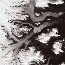
이 데이터 세트는 1999년부터 2002년까지의 Landsat 7 ETM+ 및 RADARSAT-1 SAR 이미지에서 파생된 그린란드 빙상의 완전한 15m 해상도 이미지 모자이크를 제공합니다. 이러한 방법에는 이미지 클라우드 마스킹, 팬 샤프닝, 이미지 샘플링 및 크기 조절 등이 포함됩니다. arctic gimp greenland imagery nasa polar -
ASTER L1T Radiance

참고: ASTER 기기의 기술적 문제로 인해 2024년 11월 28일과 2025년 1월 16일 사이에 데이터 수집에 차이가 있습니다. 자세한 내용은 USGS 공지사항을 참고하세요. Advanced Spaceborne Thermal Emission and Reflection Radiometer (ASTER)는 … aster 이미지 nasa nir 복사량 위성 이미지 -
2008년 브라질 산림 이미지 데이터 세트: 분석 기본 지도

이 데이터 세트는 브라질 산림 코드의 시행을 지원하기 위해 주로 2008년에 촬영된 최대 10미터 해상도의 브라질 멀티스펙트럼 (녹색, 적색, 근적외선) 기본 지도를 제공합니다. 모자이크는 SPOT 2, 4, 5 위성 데이터에서 합성되었습니다. 이는 더 높은 해상도의 … 브라질 forest-code google imagery multispectral satellite-imagery -
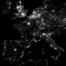
CCNL: DMSP-OLS (1992~2013)의 일관되고 수정된 야간 조명 데이터 세트 v1
일관되고 수정된 야간 조명 (CCNL) 데이터 세트는 국방 기상 프로그램 (DMSP) 운영 라인 스캔 시스템 (OLS) 버전 4의 재처리 버전입니다. 연간 불일치, 포화, 블루밍 효과의 영향을 완화하고 데이터의 … dmsp eog imagery lights nighttime ols -
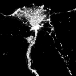
DMSP OLS: Global Radiance-Calibrated Nighttime Lights Version 4, Defense Meteorological Program Operational Linescan System(국방 기상 프로그램 운영 라인스캔 시스템)
국방 기상 프로그램 (DMSP) 운영 라인 스캔 시스템 (OLS)은 야간에 가시광선 및 근적외선 (VNIR) 방출원을 감지하는 고유한 기능을 갖추고 있습니다. 이 컬렉션에는 센서 포화가 없는 전역 야간 조명 이미지가 포함되어 있습니다. 센서는 일반적으로 …을 지원하기 위해 고이득 설정으로 작동합니다. dmsp eog imagery lights nighttime ols -
DMSP OLS: Nighttime Lights Time Series Version 4, Defense Meteorological Program Operational Linescan System(DMSP OLS: 야간 조명 시계열 버전 4, 국방 기상 프로그램 운영 라인스캔 시스템)

국방 기상 프로그램 (DMSP) 운영 라인 스캔 시스템 (OLS)은 야간에 가시광선 및 근적외선 (VNIR) 방출원을 감지하는 고유한 기능을 갖추고 있습니다. DMSP-OLS 야간 조명 시계열 버전 4는 사용 가능한 모든 보관된 DMSP-OLS 부드러운 해상도 … dmsp eog imagery lights nighttime ols -
NAIP: National Agriculture Imagery Program(국가 농업 이미지 프로그램)
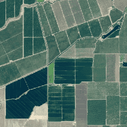
미국 농업 영상 프로그램 (NAIP)은 미국 본토의 농업 성장기에 항공 이미지를 획득합니다. NAIP 프로젝트는 사용 가능한 자금과 이미지 획득 주기에 따라 매년 계약됩니다. 2003년부터 NAIP는 5년 주기로 획득되었습니다. 2008년은 … agriculture highres imagery orthophotos usda -
SPOT 팬크로매틱 이미지 5~10m, 브라질

이 컬렉션에는 2008년경 브라질의 SPOT 2, 4, 5 위성에서 획득한 원시 팬크로매틱 (PAN) 밴드가 포함되어 있습니다. 팬크로매틱 센서는 미션에서 가장 높은 기본 공간 해상도를 제공하며 넓은 가시광선 스펙트럼 (SPOT 2의 경우 0.51~0.73µm, SPOT 4의 경우 0.61~0.68µm, SPOT 5의 경우 0.50~0.75µm)에서 빛을 포착합니다. 브라질 산림법 Google 이미지 위성 이미지 SPOT
Datasets tagged imagery in Earth Engine
[null,null,[],[],[]]