-
NAIP: 국립 농업 이미지 프로그램
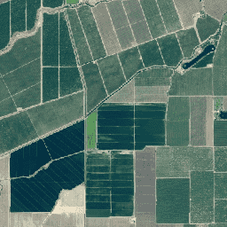
국립 농업 이미지 프로그램 (NAIP)은 미국 본토의 농업 성장기에 항공 이미지를 획득합니다. NAIP 프로젝트는 사용 가능한 예산과 이미지 획득 주기에 따라 매년 계약됩니다. 2003년부터 NAIP는 5년 주기로 획득되었습니다. 2008년은 … 농업 고해상도 이미지 정사영상 USDA -
NEON 캐노피 높이 모델 (CHM)

지표면 위의 캐노피 상단 높이 (캐노피 높이 모델, CHM) CHM은 NEON LiDAR 포인트 클라우드에서 파생되며 LiDAR 조사의 전체 공간 도메인에서 캐노피 높이 추정치의 연속적인 표면을 만들어 생성됩니다. … 항공 캐노피 산림 산림 바이오매스 고해상도 LiDAR -
NEON 캐노피 질소 함량 (CNC)

NEON 식물 엽화학 관측으로 보정되고 NEON 이미징 분광계 (NIS)에서 파생된 L1 표면 방향 반사율로 예측된 모델링된 캐노피 질소 농도입니다. 대역에는 1) 캐노피 질소 백분율, 2) 캐노피 질소 모델 불확실성, 3) 바늘 모델과 비바늘 모델의 분류 결과가 포함됩니다. 항공 캐노피 산림 고해상도 초분광 NEON -
NEON 디지털 고도 모델 (DEM)
NEON LiDAR 데이터에서 파생된 표면 (DSM) 및 지형 (DTM)의 디지털 모델입니다. DSM: 표면 특징 (식생 및 인공 구조물이 있는 지형 정보) DTM: 지표면 고도 (식생 및 인공 구조물이 제거된 지형 정보) 이미지는 평균 해수면 위의 미터 단위로 제공됩니다. 항공 DEM 고도 지형 산림 고해상도 LiDAR -
NEON RGB 카메라 이미지

가장 가까운 이웃 재샘플링을 사용하여 고정된 균일한 공간 그리드에 모자이크 처리되고 출력되는 고해상도 적색-녹색-청색 (RGB) 정사영상 카메라 이미지입니다. 공간 해상도는 0.1m입니다. 디지털 카메라는 …을 포함하는 NEON 항공 관측 플랫폼 (AOP)의 기기 모음의 일부입니다. 항공 산림 고해상도 NEON neon-prod-earthengine 정사영상 -
NEON 표면 양방향 반사율

NEON AOP 표면 양방향 반사율은 ~380nm에서 2510nm까지의 파장을 포괄하는 426개의 대역을 포함하는 초분광 VSWIR (가시광선에서 단파 적외선) 데이터 제품입니다. 반사율은 10000의 계수로 조정됩니다. 1340~1445nm 및 1790~1955nm 사이의 파장은 …으로 설정됩니다. 항공 산림 고해상도 초분광 NEON neon-prod-earthengine -
Planet SkySat 공개 정사영상, 다중 스펙트럼

Planet Labs Inc. SkySat 위성의 이 데이터는 2015년 실험적인 'Skybox for Good 베타' 프로그램과 다양한 위기 대응 이벤트 및 기타 몇 가지 프로젝트를 위해 수집되었습니다. 데이터는 5대역 다중 스펙트럼/팬 컬렉션과 …에서 사용할 수 있습니다. 고해상도 다중 스펙트럼 팬샤프닝 Planet 위성 이미지 SkySat -
Planet SkySat 공개 정사영상, RGB

Planet Labs Inc. SkySat 위성의 이 데이터는 2015년 실험적인 'Skybox for Good 베타' 프로그램과 다양한 위기 대응 이벤트 및 기타 몇 가지 프로젝트를 위해 수집되었습니다. 데이터는 5대역 다중 스펙트럼/팬 컬렉션과 …에서 사용할 수 있습니다. 고해상도 팬샤프닝 Planet RGB 위성 이미지 SkySat
Datasets tagged highres in Earth Engine
[null,null,[],[],["Planet Labs Inc. SkySat satellites collected data for the \"Skybox for Good Beta\" program in 2015 and crisis response events. This data is available in 5-band Multispectral/Pan and RGB collections. The National Agriculture Imagery Program (NAIP) acquires aerial imagery during U.S. agricultural growing seasons, beginning on a 5-year cycle in 2003. High-resolution RGB camera images from the NEON Airborne Observation Platform (AOP) are also available, featuring 0.1m spatial resolution.\n"]]