- 데이터 세트 제공
- 1999-06-30T00:00:00Z–2002-09-04T00:00:00Z
- 데이터 세트 출처
- CIRES의 NASA NSIDC DAAC
- 태그
설명
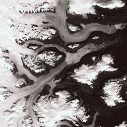
이 데이터 세트는 1999~2002년의 Landsat 7 ETM+ 및 RADARSAT-1 SAR 이미지에서 파생된 그린란드 빙상의 완전한 15m 해상도 이미지 모자이크를 제공합니다. 이러한 방법에는 이미지 클라우드 마스킹, 팬 선명화, 이미지 샘플링 및 크기 조절, 이미지 공동 등록이 포함됩니다. 처리 방법에 관한 자세한 내용은 Howat(2014)을 참고하세요.
참고
- GIMP DEM 또는 GIMP 2000 이미지 모자이크 이미지를 사용하는 경우 해당 15m 해양 마스크 이미지인 Greenland Ice Mapping Project (GIMP) Land Ice and Ocean Classification Mask를 사용하여 그린란드 해안선 외부 영역을 마스크 처리하는 것이 유용할 수 있습니다.
- SAR 데이터는 20m 해상도로 배포됩니다. 데이터는 Landsat 밴드 8의 해상도와 일치하도록 양선형 보간을 통해 15m로 업샘플링되었습니다.
대역
대역
픽셀 크기: 다양함
| 이름 | 픽셀 크기 | Wavelength | 설명 |
|---|---|---|---|
B1 |
15m | 0.45~0.52μm | Landsat 7 ETM+ 파란색 |
B2 |
15m | 0.52~0.60μm | Landsat 7 ETM+ 녹색 |
B3 |
15m | 0.63~0.69μm | Landsat 7 ETM+ 빨간색 |
B4 |
15m | 0.77~0.90μm | Landsat 7 ETM+ 근적외선 |
B5 |
30m | 1.55~1.75μm | Landsat 7 ETM+ 단파 적외선 1 |
B6_low_gain |
30m | 10.40~12.50μm | Landsat 7 ETM+ 저이득 열 적외선 1. 이 밴드는 동적 범위가 확장되고 방사선 측정 해상도 (민감도)가 낮으며 높은 디지털 번호 (DN) 값에서 포화도가 낮습니다. 60분에서 30분으로 리샘플링되었습니다. |
B6_high_gain |
30m | 10.40~12.50μm | Landsat 7 ETM+ 고이득 열 적외선 1. 이 대역은 동적 범위가 더 제한적이지만 방사 측정 해상도 (감도)가 더 높습니다. 60분에서 30분으로 리샘플링되었습니다. |
B7 |
30m | 2.08~2.35μm | Landsat 7 ETM+ 단파 적외선 2 |
B8 |
15m | 0.52~0.90μm | Landsat 7 ETM+ 전정색 |
B8_radarsat |
15m | 없음 | RADARSAT-1 합성개구레이더 진폭 이미지 |
이용약관
이용약관
이 데이터를 사용하려면 제공된 인용을 사용하여 이 데이터 세트의 사용을 인용해야 합니다.
인용
Howat, I.M., A. Negrete, B.E. Smith, 2014, The Greenland Ice Mapping Project (GIMP) land classification and surface elevation datasets, The Cryosphere, 8, 1509-1518, doi:10.5194/tc-8-1509-2014 article pdf
DOI
Earth Engine으로 탐색
코드 편집기(JavaScript)
var dataset = ee.Image('OSU/GIMP/2000_IMAGERY_MOSAIC');
var greenlandImage = dataset.select(['B3', 'B2', 'B1']);
var visParams = {
  min: 0.0,
  max: 255.0,
};
Map.setCenter(-29.1605, 70.4, 9);
Map.addLayer(greenlandImage, visParams, 'Greenland Pansharpened Image');