-
2000년 그린란드 모자이크 - 그린란드 얼음 매핑 프로젝트 (GIMP)
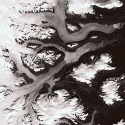
이 데이터 세트는 1999년부터 2002년까지의 Landsat 7 ETM+ 및 RADARSAT-1 SAR 이미지에서 파생된 그린란드 빙상의 완전한 15m 해상도 이미지 모자이크를 제공합니다. 이러한 방법에는 이미지 클라우드 마스킹, 팬 샤프닝, 이미지 샘플링 및 크기 조절 등이 포함됩니다. arctic gimp greenland imagery nasa polar -
CryoSat-2 남극 1km DEM

이 데이터 세트는 2010년 7월부터 2016년 7월까지 CryoSat-2 위성 레이더 고도계로 기록된 관측을 기반으로 한 남극 빙상 및 빙붕의 디지털 고도 모델 (DEM)입니다. DEM은 1, … antarctica dem elevation elevation-topography polar -
그린란드 DEM - 그린란드 매핑 프로젝트 (GIMP)
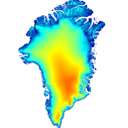
이 디지털 고도 모델 (DEM)은 약 82.5°N 남쪽의 빙상 주변부 및 가장자리 (즉, 평형선 고도 아래)에 대한 ASTER 및 SPOT-5 DEM의 조합과 빙상 내부 및 최북단의 AVHRR 포토클리노메트리 (Scambos 및 … arctic elevation-topography gimp greenland nasa polar -
그린란드 얼음 및 해양 마스크 - 그린란드 매핑 프로젝트 (GIMP)

이 데이터 세트는 그린란드 빙상의 완전한 육지 얼음 및 해양 분류 마스크를 15m로 제공합니다. 얼음 덮개는 USGS에서 배포한 Landsat 7 Enhanced Thematic Mapper Plus (ETM+)의 직교 보정된 전정색 (밴드 8) 이미지와 … arctic cryosphere gimp greenland ice nasa -
MEaSUREs Greenland Ice Velocity: Selected Glacier Site Velocity Maps from Optical Images Version 2(MEaSUREs 그린란드 얼음 속도: 광학 이미지 버전 2에서 선택한 빙하 사이트 속도 지도)
NASA Making Earth System Data Records for Use in Research Environments (MEaSUREs) 프로그램의 일부인 이 데이터 세트는 선택한 빙하 출구 지역의 평균 월별 속도 지도로 구성되어 있습니다. 지도는 Landsat에서 획득한 광학 이미지 쌍 간에 보이는 특징을 추적하여 생성됩니다. arctic cryosphere gimp greenland ice nasa
Datasets tagged polar in Earth Engine
[null,null,[],[],[]]