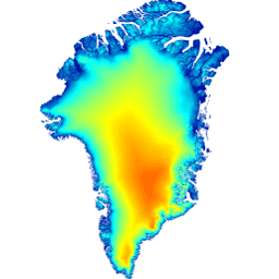
이 디지털 고도 모델 (DEM)은 약 82.5°N 남쪽의 빙상 주변부 및 가장자리(즉, 평형선 고도 아래)에 대한 ASTER 및 SPOT-5 DEM의 조합과 빙상 내부 및 최북단의 AVHRR 포토클리노메트리로 구성됩니다 (Scambos 및 Haran, 2002).
SPOT-5 DEM은 Polar Ice: Reference Images & Topographies(SPIRIT) 프로젝트의 Spot5 입체 측량의 일부로 제작 및 배포되었습니다 (Korona et al., 2009). 해양 표면은 GIMP 육지 분류 마스크를 사용하여 마스킹되었으며 CNES CLS11 평균 해수면 높이 (Schaeffer et al., 2012년 참조).
참고
모든 육지 고도 데이터는 2003~2009년 기간의 평균 ICESat 고도에 수평 및 수직으로 등록되므로 DEM의 명목 날짜는 2007년입니다. 하지만 70°0N 이남의 주요 출구 빙하와 같이 급격한 변화가 있는 지역에서 DEM을 사용할 때는 주의해야 합니다.
DEM의 해상도는 30m이지만 DEM의 '실제' 해상도는 SPOT-5 적용 범위 영역(Korona et al. 2009 참고)의 40m에서 포토클리노메트리 영역의 500m까지 다양합니다.
ICESat과 관련된 빙상 전체 평균 제곱근 검증 오류는 +/-10m이며, 대부분의 빙상 표면에서 +/-1m에 가까운 범위에서 높은 지형의 영역에서 +/-30m에 이릅니다.
Howat, I.M., A. Negrete, B.E. Smith, 2014, The Greenland Ice
Mapping Project (GIMP) land classification and surface elevation
datasets, The Cryosphere, 8, 1509-1518,
doi:10.5194/tc-8-1509-2014article pdf
이 디지털 고도 모델 (DEM)은 약 82.5°N 남쪽의 빙상 주변부 및 가장자리 (즉, 평형선 고도 아래)에 대한 ASTER 및 SPOT-5 DEM의 조합과 빙상 내부 및 최북단의 AVHRR 포토클리노메트리로 구성됩니다 (Scambos 및 Haran, 2002). SPOT-5 DEM은 …
[null,null,[],[[["\u003cp\u003eThe OSU/GIMP/DEM dataset provides a Digital Elevation Model (DEM) of Greenland, primarily constructed from ASTER, SPOT-5 DEMs, and AVHRR photoclinometry.\u003c/p\u003e\n"],["\u003cp\u003eThe DEM has a resolution of 30 meters and is registered to average ICESat elevations for the 2003-2009 time period.\u003c/p\u003e\n"],["\u003cp\u003eThis dataset covers Greenland's ice sheet, including its periphery, margin, and interior, with varying resolutions based on data source.\u003c/p\u003e\n"],["\u003cp\u003eThe dataset has a nominal date of 2007, although caution is advised in areas of rapid change, such as major outlet glaciers.\u003c/p\u003e\n"],["\u003cp\u003eUsers must cite the dataset using the provided citations when utilizing the data.\u003c/p\u003e\n"]]],[],null,["# Greenland DEM - Greenland Mapping Project (GIMP)\n\nDataset Availability\n: 1999-06-30T00:00:00Z--2002-09-04T00:00:00Z\n\nDataset Provider\n:\n\n\n [NASA NSIDC DAAC at CIRES](https://doi.org/10.5067/NV34YUIXLP9W)\n\nTags\n:\n[arctic](/earth-engine/datasets/tags/arctic) [elevation-topography](/earth-engine/datasets/tags/elevation-topography) [gimp](/earth-engine/datasets/tags/gimp) [greenland](/earth-engine/datasets/tags/greenland) [nasa](/earth-engine/datasets/tags/nasa) [polar](/earth-engine/datasets/tags/polar) \n\n#### Description\n\nThis Digital Elevation Model (DEM) is constructed from a combination\nof ASTER and SPOT-5 DEM's for the ice sheet periphery and margin\n(i.e. below the equilbrium line elevation) south of\napproximately 82.5°N and AVHRR photoclinometry in the ice sheet\ninterior and far north (Scambos and Haran, 2002).\n\nSPOT-5 DEM's were produced and distributed as part of the Spot5\nstereoscopic survey of Polar Ice: Reference Images \\& Topographies\n(SPIRIT) project (Korona et al., 2009). Ocean surfaces were masked\nusing the GIMP Land Classification mask and replaced with the\nCNES CLS11 mean sea surface height (Schaeffer et al., 2012).\n\n**Note**\n\n- All land elevation data is horizontally and vertically registered to average ICESat elevations for the 2003-2009 time period, and therefore the DEM has a nominal date of 2007, although care must be taken when using the DEM in areas of rapid change, such as major outlet glaciers south of 70°0N.\n- The DEM has a resolution of 30 m, although the \"true\" resolution of the DEM will vary from 40 m in areas of SPOT-5 coverage (see Korona et al. 2009) to 500 m in areas of photoclinometry.\n- The ice-sheet-wide root-mean-squared validation error relative to ICESat is +/-10 m, rangining from close to +/- 1 m over most ice surfaces to +/- 30 m in areas of high relief.\n\n[General documentation](https://doi.org/10.5067/NV34YUIXLP9W)\n\n### Bands\n\n**Bands**\n\n| Name | Units | Pixel Size | Description |\n|-------------|-------|------------|-------------|\n| `elevation` | m | 30 meters | Elevation |\n\n### Terms of Use\n\n**Terms of Use**\n\nAs a condition of using these data, you must cite the use of this\ndata set using the given citation.\n\n### Citations\n\nCitations:\n\n- Howat, I.M., A. Negrete, B.E. Smith, 2014, The Greenland Ice\n Mapping Project (GIMP) land classification and surface elevation\n datasets, The Cryosphere, 8, 1509-1518,\n [doi:10.5194/tc-8-1509-2014](https://doi.org/10.5194/tc-8-1509-2014)\n [article pdf](https://www.the-cryosphere.net/8/1509/2014/tc-8-1509-2014.pdf)\n\n### DOIs\n\n- \u003chttps://doi.org/10.5067/NV34YUIXLP9W\u003e\n\n### Explore with Earth Engine\n\n| **Important:** Earth Engine is a platform for petabyte-scale scientific analysis and visualization of geospatial datasets, both for public benefit and for business and government users. Earth Engine is free to use for research, education, and nonprofit use. To get started, please [register for Earth Engine access.](https://console.cloud.google.com/earth-engine)\n\n### Code Editor (JavaScript)\n\n```javascript\nvar dataset = ee.Image('OSU/GIMP/DEM');\nvar elevation = dataset.select('elevation');\nvar elevationVis = {\n min: 0.0,\n max: 2000.0,\n};\nMap.setCenter(-41.0, 76.0, 4);\nMap.addLayer(elevation, elevationVis, 'Elevation');\n```\n[Open in Code Editor](https://code.earthengine.google.com/?scriptPath=Examples:Datasets/OSU/OSU_GIMP_DEM) \n[Greenland DEM - Greenland Mapping Project (GIMP)](/earth-engine/datasets/catalog/OSU_GIMP_DEM) \nThis Digital Elevation Model (DEM) is constructed from a combination of ASTER and SPOT-5 DEM's for the ice sheet periphery and margin (i.e. below the equilbrium line elevation) south of approximately 82.5°N and AVHRR photoclinometry in the ice sheet interior and far north (Scambos and Haran, 2002). SPOT-5 DEM's were ... \nOSU/GIMP/DEM, arctic,elevation-topography,gimp,greenland,nasa,polar \n1999-06-30T00:00:00Z/2002-09-04T00:00:00Z \n58.795926930232035 -89.32179714240877 83.95392768557056 7.556480769227746 \nGoogle Earth Engine \nhttps://developers.google.com/earth-engine/datasets\n\n- [https://doi.org/10.5067/NV34YUIXLP9W](https://doi.org/https://doi.org/10.5067/NV34YUIXLP9W)\n- [https://doi.org/10.5067/NV34YUIXLP9W](https://doi.org/https://developers.google.com/earth-engine/datasets/catalog/OSU_GIMP_DEM)"]]