-
2000 그린란드 모자이크 - 그린란드 얼음 매핑 프로젝트 (GIMP)
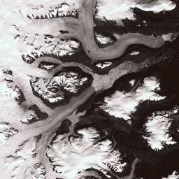
이 데이터 세트는 1999년부터 2002년까지의 Landsat 7 ETM+ 및 RADARSAT-1 SAR 이미지에서 파생된 그린란드 빙상의 완전한 15m 해상도 이미지 모자이크를 제공합니다. 이 방법에는 이미지 클라우드 마스크, 팬 샤프닝, 이미지 샘플링 및 크기 조정을 결합하는 방법이 포함됩니다. 북극 gimp 그린란드 이미지 nasa polar -
ArcticDEM 모자이크 V4.1
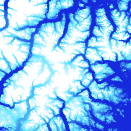
ArcticDEM은 광학 스테레오 이미지, 고성능 컴퓨팅, 오픈소스 사진 측량 소프트웨어를 사용하여 북극의 고해상도 고품질 디지털 표면 모델 (DSM)을 자동으로 생성하기 위한 국가지리정보국 (NGA) 및 국립과학재단 (NSF)의 민관 이니셔티브입니다. 여기에는 초목, 나무 캐노피, 건물 등이 포함됩니다. 북극 dem 고도-지형 지구물리학 pgc umn -
ArcticDEM 스트립
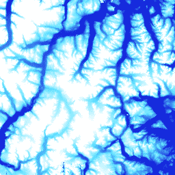
ArcticDEM은 광학 스테레오 이미지, 고성능 컴퓨팅, 오픈소스 사진 측량 소프트웨어를 사용하여 북극의 고해상도 고품질 디지털 표면 모델 (DSM)을 자동으로 생성하기 위한 국가지리정보국 (NGA) 및 국립과학재단 (NSF)의 민관 이니셔티브입니다. 여기에는 초목, 나무 캐노피, 건물 등이 포함됩니다. 북극 dem 고도-지형 지구물리학 pgc umn -
그린란드 DEM - 그린란드 매핑 프로젝트 (GIMP)
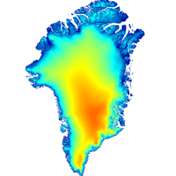
이 디지털 고도 모델 (DEM)은 약 82.5°N 남쪽의 빙상 주변부 및 가장자리 (즉, 평형선 고도 아래)에 대한 ASTER 및 SPOT-5 DEM의 조합과 빙상 내부 및 극북 (Scambos 및 … 북극 고도-지형 gimp 그린란드 nasa polar -
그린란드 얼음 및 해양 마스크 - 그린란드 매핑 프로젝트 (GIMP)

이 데이터 세트는 그린란드 빙상에 대한 완전한 육상 얼음 및 해양 분류 마스크를 15m로 제공합니다. 얼음 덮개는 USGS에서 배포한 Landsat 7 Enhanced Thematic Mapper Plus (ETM+)의 정사보정된 팬크로매틱 (밴드 8) 이미지와 … 북극 빙권 gimp 그린란드 얼음 nasa -
MEaSUREs 그린란드 얼음 속도: 광학 이미지 버전 2의 선택된 빙하 출구 지역 속도 지도
NASA 연구 환경에서 지구 시스템 데이터 기록 사용 (MEaSUREs) 프로그램의 일부인 이 데이터 세트는 선택된 빙하 출구 지역의 월별 평균 속도 지도로 구성됩니다. 지도는 Landsat에서 획득한 광학 이미지 쌍 간의 눈에 보이는 특징을 추적하여 생성됩니다. 북극 빙권 gimp 그린란드 얼음 nasa
Datasets tagged arctic in Earth Engine
[null,null,[],[],["The content details datasets from the Greenland Ice Mapping Project (GIMP) and ArcticDEM initiatives. GIMP provides a 15m resolution ice/ocean classification mask and a 2000 image mosaic of Greenland derived from Landsat 7 and RADARSAT-1. It also includes a digital elevation model (DEM) and mean monthly glacier velocity maps. ArcticDEM, a joint NGA/NSF project, offers high-resolution digital surface models (DSMs) of the Arctic, encompassing features like vegetation and buildings.\n"]]