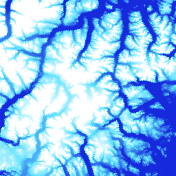
ArcticDEM은 광학 스테레오 이미지, 고성능 컴퓨팅, 오픈소스 사진 측량 소프트웨어를 사용하여 고해상도, 고품질의 북극 디지털 표면 모델 (DSM)을 자동으로 생성하기 위한 국립 지리 공간 정보국 (NGA) 및 국립 과학 재단 (NSF)의 공공-민간 이니셔티브입니다. 여기에는 식물, 수관, 건물, 기타 인공 표면 지형지물이 포함됩니다. 2m 애셋은 스트립 간의 투영 차이로 인해 단일 모자이크가 아닌 스트립 모음입니다.
모자이크 처리된 DEM 파일은 블렌딩되고 페더링되어 무효 영역과 가장자리 일치 아티팩트를 줄인 최고 품질 스트립 DEM 파일에서 컴파일됩니다. 절대 정확도를 높이기 위해 필터링된 IceSAT 고도계 데이터가 래스터 파일에 적용되었습니다.
이 버전 (V4.1) 모자이크에는 데이터 출처 및 불확실성에 관한 정보를 제공하기 위해 'count', 'mad','mindate', 'maxdate'라는 추가 래스터 밴드가 포함됩니다.
대역
픽셀 크기 2미터
대역
이름
단위
최소
최대
픽셀 크기
설명
elevation
m
-416.45*
5971.24*
미터
고도
count
미터
해당 픽셀의 고도 값을 계산하는 데 사용된 소스 DEM의 수입니다.
mad
m
미터
소스 데이터 세트 스택의 중앙값 고도 값에서 중앙값 절대 편차입니다.
mindate
미터
모자이크를 빌드하는 데 사용된 소스 DEM의 가장 빠른 날짜입니다(2000년 1월 1일 이후의 일수).
maxdate
미터
모자이크를 빌드하는 데 사용된 소스 DEM의 최신 날짜입니다(2000년 1월 1일 이후의 일수).
datamask
미터
데이터 마스크는 고도가 0인지 1인지를 나타냅니다. 여기서 0은 품질 관리 단계에서 다른 데이터 세트와 병합되거나 NoData로 마스크 처리되었음을 나타냅니다.
1은 오하이오 주립대학교의 SETSM(TIN 기반 검색 공간 최소화 소프트웨어 패키지를 사용한 표면 추출)에서 출력한 것을 나타냅니다.
* 예상 최솟값 또는 최댓값
이용약관
이용약관
국립과학재단 (PGC의 기본 자금 지원 출처) 정책에 따라 연구자는 모든 출판물, 웹페이지, 미디어 인터뷰에서 NSF 지원을 인정해야 합니다.
Earth Engine에서 PGC 데이터를 사용함으로써 사용자는 PGC와 NSF의 후원을 인용하는 데 동의합니다. PGC에서 제공하는 모든 서드 파티 데이터의 원본 소스도 적절하게 표시해야 합니다.
ArcticDEM은 광학 스테레오 이미지, 고성능 컴퓨팅, 오픈소스 사진 측량 소프트웨어를 사용하여 고해상도 고품질 북극 디지털 표면 모델 (DSM)을 자동으로 생성하기 위한 국가지리정보국 (NGA) 및 국립과학재단 (NSF)의 공공-민간 이니셔티브입니다. 여기에는 식물, 수관, 건물, 기타 인공 지형지물이 포함됩니다. …
[null,null,[],[],[],null,["# ArcticDEM Mosaic V4.1\n\nDataset Availability\n: 2012-06-03T00:00:00Z--2020-09-03T23:59:59Z\n\nDataset Provider\n:\n\n\n [University of Minnesota Polar Geospatial Center](https://www.pgc.umn.edu/data/arcticdem/)\n\nTags\n:\n[arctic](/earth-engine/datasets/tags/arctic) [dem](/earth-engine/datasets/tags/dem) [elevation-topography](/earth-engine/datasets/tags/elevation-topography) [geophysical](/earth-engine/datasets/tags/geophysical) [pgc](/earth-engine/datasets/tags/pgc) [umn](/earth-engine/datasets/tags/umn) \n\n#### Description\n\nArcticDEM is a National Geospatial-Intelligence Agency (NGA) and National\nScience Foundation (NSF) public-private initiative to automatically produce\na high-resolution, high-quality digital surface model (DSM) of the Arctic\nusing optical stereo imagery, high-performance computing, and open source\nphotogrammetry software. It includes vegetation, tree canopy, buildings, and\nother man-made surface features. The 2m asset is a collection of strips rather\nthan a single mosaic due to projection differences between strips.\n\nMosaicked DEM files are compiled from the best quality strip DEM files\nwhich have been blended and feathered to reduce void areas and edge-matching\nartifacts. Filtered IceSAT altimetry data has been applied to the raster\nfiles to improve absolute accuracy.\n\nThese version (V4.1) mosaics include additional raster bands:\n'count', 'mad','mindate', and 'maxdate' to provide\ninformation on data provenance and uncertainty.\n\n### Bands\n\n\n**Pixel Size**\n\n2 meters\n\n**Bands**\n\n| Name | Units | Min | Max | Pixel Size | Description |\n|-------------|-------|-----------|-----------|------------|-------------------------------------------------------------------------------------------------------------------------------------------------------------------------------------------------------------------------------------------------------------------------------------------------------|\n| `elevation` | m | -416.45\\* | 5971.24\\* | meters | Elevation |\n| `count` | | | | meters | Number of source DEMs used to calculate the elevation value at that pixel. |\n| `mad` | m | | | meters | Median absolute deviation of the stack of source datasets from the median elevation value. |\n| `mindate` | | | | meters | Earliest date of the source DEMs used to build the mosaic, as the number of days since January 1, 2000. |\n| `maxdate` | | | | meters | Latest date of the source DEMs used to build the mosaic, as the number of days since January 1, 2000. |\n| `datamask` | | | | meters | Data mask indicates whether the elevation was 0 or 1. where 0 indicates , Filled/merged with another dataset or masked out as NoData in quality control steps. 1 indicates output by SETSM, the Ohio State University's Surface Extraction with TIN-based Search-space Minimization software package. |\n\n\\* estimated min or max value\n\n### Terms of Use\n\n**Terms of Use**\n\nNational Science Foundation (PGC's primary funding source) policy requires\nresearchers to acknowledge NSF support in all publications, web pages, and\nmedia interviews.\n\nBy using PGC data in Earth Engine, users agree to cite PGC\nand its sponsorship by the NSF. The original source of any third-party data\nsupplied by PGC must also be properly attributed.\n\nFor more information see the PGC's\n[Acknowledgement Policy](https://www.pgc.umn.edu/guides/user-services/acknowledgement-policy/).\n\n### Citations\n\nCitations:\n\n- DEM(s) created by the Polar Geospatial Center from DigitalGlobe, Inc. imagery.\n Porter, Claire; Morin, Paul; Howat, Ian; Noh, Myoung-Jon; Bates, Brian;\n Peterman, Kenneth; Keesey, Scott; Schlenk, Matthew; Gardiner, Judith;\n Tomko, Karen; Willis, Michael; Kelleher, Cole; Cloutier, Michael; Husby, Eric;\n Foga, Steven; Nakamura, Hitomi; Platson, Melisa; Wethington, Michael, Jr.;\n Williamson, Cathleen; Bauer, Gregory; Enos, Jeremy; Arnold, Galen; Kramer, William;\n Becker, Peter; Doshi, Abhijit; D'Souza, Cristelle; Cummens, Pat; Laurier, Fabien;\n Bojesen, Mikkel, 2018, ArcticDEM, Harvard Dataverse, V1, \\[Date Accessed\\].\n\n### DOIs\n\n- \u003chttps://doi.org/10.7910/DVN/OHHUKH\u003e\n\n### Explore with Earth Engine\n\n| **Important:** Earth Engine is a platform for petabyte-scale scientific analysis and visualization of geospatial datasets, both for public benefit and for business and government users. Earth Engine is free to use for research, education, and nonprofit use. To get started, please [register for Earth Engine access.](https://console.cloud.google.com/earth-engine)\n\n### Code Editor (JavaScript)\n\n```javascript\nvar dataset = ee.Image('UMN/PGC/ArcticDEM/V4/2m_mosaic');\n\nvar elevationVis = {\n min: -50.0,\n max: 1000.0,\n palette: ['0d13d8', '60e1ff', 'ffffff'],\n bands: ['elevation'],\n};\n\nvar countVis = {\n min: 0,\n max: 10,\n palette: [\n 'black',\n 'blue',\n 'purple',\n 'cyan',\n 'green',\n 'yellow',\n 'red',\n ],\n bands: ['count'],\n};\n\nvar madVis = {\n min: 0,\n max: 50,\n palette: [\n '006633',\n 'E69800',\n 'D4E157',\n 'FFF59D',\n ],\n bands: ['mad'],\n};\n\nvar datamaskVis = {\n min: 0,\n max: 1,\n palette: [\n 'black',\n 'white',\n ],\n bands: ['datamask'],\n};\n\nMap.setCenter(-63.402, 66.368, 7);\n\nMap.addLayer(dataset, elevationVis, 'Elevation', true);\nMap.addLayer(dataset, countVis, 'Data Count', false);\nMap.addLayer(dataset, madVis, 'MAD', false);\nMap.addLayer(dataset, datamaskVis, 'Data Mask', false);\n```\n[Open in Code Editor](https://code.earthengine.google.com/?scriptPath=Examples:Datasets/UMN/UMN_PGC_ArcticDEM_V4_2m_mosaic) \n[ArcticDEM Mosaic V4.1](/earth-engine/datasets/catalog/UMN_PGC_ArcticDEM_V4_2m_mosaic) \nArcticDEM is a National Geospatial-Intelligence Agency (NGA) and National Science Foundation (NSF) public-private initiative to automatically produce a high-resolution, high-quality digital surface model (DSM) of the Arctic using optical stereo imagery, high-performance computing, and open source photogrammetry software. It includes vegetation, tree canopy, buildings, and other man-made surface features. The ... \nUMN/PGC/ArcticDEM/V4/2m_mosaic, arctic,dem,elevation-topography,geophysical,pgc,umn \n2012-06-03T00:00:00Z/2020-09-03T23:59:59Z \n50 -180 90 180 \nGoogle Earth Engine \nhttps://developers.google.com/earth-engine/datasets\n\n- [https://doi.org/10.7910/DVN/OHHUKH](https://doi.org/https://www.pgc.umn.edu/data/arcticdem/)\n- [https://doi.org/10.7910/DVN/OHHUKH](https://doi.org/https://developers.google.com/earth-engine/datasets/catalog/UMN_PGC_ArcticDEM_V4_2m_mosaic)"]]