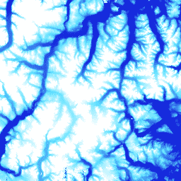
ArcticDEM은 광학 스테레오 이미지, 고성능 컴퓨팅, 오픈소스 사진 측량 소프트웨어를 사용하여 고해상도, 고품질의 북극 디지털 표면 모델 (DSM)을 자동으로 생성하기 위한 국립 지리 공간 정보국 (NGA) 및 국립 과학 재단 (NSF)의 공공-민간 이니셔티브입니다. 여기에는 식물, 수관, 건물, 기타 인공 표면 지형지물이 포함됩니다. 2m 애셋은 스트립 간의 투영 차이로 인해 단일 모자이크가 아닌 스트립 모음입니다.
스트립 DEM 파일은 DigitalGlobe의 극궤도 위성 컨스텔레이션에서 수집한 입력 스테레오 쌍 이미지 스와스의 중첩 영역에 해당합니다. DEM 스트립 크기는 이미지를 획득한 위성 센서와 수집의 오프나디르 각도에 따라 달라집니다. 대부분의 스트립은 너비가 16~18km이고 길이가 110~120km입니다.
대역
픽셀 크기 2미터
대역
이름
단위
픽셀 크기
설명
elevation
m
미터
고도
matchtag
미터
DEM 픽셀 처리를 나타내는 비트마스크 래스터
matchtag의 비트 마스크
비트 0: Pixel 처리
0: 픽셀이 보간되었습니다.
1: 픽셀이 스테레오 일치에서 파생됨
이용약관
이용약관
국립과학재단 (PGC의 기본 자금 지원 출처) 정책에 따라 연구자는 모든 출판물, 웹페이지, 미디어 인터뷰에서 NSF 지원을 인정해야 합니다.
Earth Engine에서 PGC 데이터를 사용함으로써 사용자는 PGC와 NSF의 후원을 인용하는 데 동의합니다. PGC에서 제공하는 모든 서드 파티 데이터의 원본 소스도 적절하게 표시해야 합니다.
ArcticDEM은 광학 스테레오 이미지, 고성능 컴퓨팅, 오픈소스 사진 측량 소프트웨어를 사용하여 고해상도 고품질 북극 디지털 표면 모델 (DSM)을 자동으로 생성하기 위한 국가지리정보국 (NGA) 및 국립과학재단 (NSF)의 공공-민간 이니셔티브입니다. 여기에는 식물, 수관, 건물, 기타 인공 지형지물이 포함됩니다. …
[null,null,[],[[["\u003cp\u003eArcticDEM provides a high-resolution (2m) digital surface model (DSM) of the Arctic, including vegetation, buildings, and other surface features.\u003c/p\u003e\n"],["\u003cp\u003eIt is created from optical stereo imagery using high-performance computing and open source photogrammetry software.\u003c/p\u003e\n"],["\u003cp\u003eThe dataset is a collection of strips covering the Arctic region from 2009 to 2017, with varying dimensions depending on the satellite sensor and collection angle.\u003c/p\u003e\n"],["\u003cp\u003eUsers must acknowledge NSF support and cite PGC when using this data, as per the terms of use.\u003c/p\u003e\n"],["\u003cp\u003eData can be explored and analyzed using Google Earth Engine, a platform for scientific analysis and visualization of geospatial datasets.\u003c/p\u003e\n"]]],["The ArcticDEM dataset, provided by the University of Minnesota Polar Geospatial Center, offers a high-resolution digital surface model (DSM) of the Arctic from 2009 to 2017. Utilizing stereo imagery and photogrammetry, it captures surface features with a 2-meter pixel size. Data is in strips and includes elevation data and a matchtag for pixel processing information. The dataset, accessible via Google Earth Engine, requires NSF acknowledgment and appropriate citations for use.\n"],null,["# ArcticDEM Strips\n\nDataset Availability\n: 2009-08-16T00:00:00Z--2017-03-12T00:00:00Z\n\nDataset Provider\n:\n\n\n [University of Minnesota Polar Geospatial Center](https://www.pgc.umn.edu/data/arcticdem/)\n\nTags\n:\n[arctic](/earth-engine/datasets/tags/arctic) [dem](/earth-engine/datasets/tags/dem) [elevation-topography](/earth-engine/datasets/tags/elevation-topography) [geophysical](/earth-engine/datasets/tags/geophysical) [pgc](/earth-engine/datasets/tags/pgc) [umn](/earth-engine/datasets/tags/umn) \n\n#### Description\n\nArcticDEM is a National Geospatial-Intelligence Agency (NGA) and National\nScience Foundation (NSF) public-private initiative to automatically produce\na high-resolution, high-quality digital surface model (DSM) of the Arctic\nusing optical stereo imagery, high-performance computing, and open source\nphotogrammetry software. It includes vegetation, tree canopy, buildings, and\nother man-made surface features. The 2m asset is a collection of strips rather\nthan a single mosaic due to projection differences between strips.\n\nStrip DEM files correspond to the overlapping area of the input stereopair\nimage swaths as they are collected by DigitalGlobe's constellation of\npolar-orbiting satellites. Strip DEM dimensions will vary according to the\nsatellite sensor that acquired the images and the off-nadir angle of\ncollection. Most strips are between 16km and 18km in width, and 110km and\n120km in length.\n\n### Bands\n\n\n**Pixel Size**\n\n2 meters\n\n**Bands**\n\n| Name | Units | Pixel Size | Description |\n|-------------|-------|------------|-------------------------------------------------|---|---|---|---|---|---|---|---|---|---|---|---|---|---|---|---|---|---|---|---|---|---|---|---|---|---|---|---|---|---|---|---|---|---|---|---|---|---|---|---|---|---|---|---|---|---|---|---|---|---|---|---|---|---|---|---|---|---|---|---|---|---|---|---|---|---|---|---|---|---|---|---|---|---|---|---|---|---|---|---|---|---|---|---|---|---|---|---|---|---|---|---|---|---|---|---|\n| `elevation` | m | meters | Elevation |\n| `matchtag` | | meters | Bitmask raster indicating DEM pixels processing |\n| Bitmask for matchtag - Bit 0: Pixel processing - 0: Pixels have been interpolated - 1: Pixels are derived from a stereo match ||||||||||||||||||||||||||||||||||||||||||||||||||||||||||||||||||||||||||||||||||||||||||||||||||||\n\n### Terms of Use\n\n**Terms of Use**\n\nNational Science Foundation (PGC's primary funding source) policy requires\nresearchers to acknowledge NSF support in all publications, web pages, and\nmedia interviews.\n\nBy using PGC data in Earth Engine, users agree to cite PGC\nand its sponsorship by the NSF. The original source of any third-party data\nsupplied by PGC must also be properly attributed.\n\nFor more information see the PGC's\n[Acknowledgement Policy](https://www.pgc.umn.edu/guides/user-services/acknowledgement-policy/).\n\n### Citations\n\nCitations:\n\n- DEM(s) created by the Polar Geospatial Center from DigitalGlobe, Inc. imagery.\n Porter, Claire; Morin, Paul; Howat, Ian; Noh, Myoung-Jon; Bates, Brian;\n Peterman, Kenneth; Keesey, Scott; Schlenk, Matthew; Gardiner, Judith;\n Tomko, Karen; Willis, Michael; Kelleher, Cole; Cloutier, Michael; Husby, Eric;\n Foga, Steven; Nakamura, Hitomi; Platson, Melisa; Wethington, Michael, Jr.;\n Williamson, Cathleen; Bauer, Gregory; Enos, Jeremy; Arnold, Galen; Kramer, William;\n Becker, Peter; Doshi, Abhijit; D'Souza, Cristelle; Cummens, Pat; Laurier, Fabien;\n Bojesen, Mikkel, 2018, ArcticDEM, Harvard Dataverse, V1, \\[Date Accessed\\].\n\n### DOIs\n\n- \u003chttps://doi.org/10.7910/DVN/OHHUKH\u003e\n\n### Explore with Earth Engine\n\n| **Important:** Earth Engine is a platform for petabyte-scale scientific analysis and visualization of geospatial datasets, both for public benefit and for business and government users. Earth Engine is free to use for research, education, and nonprofit use. To get started, please [register for Earth Engine access.](https://console.cloud.google.com/earth-engine)\n\n### Code Editor (JavaScript)\n\n```javascript\nvar dataset = ee.ImageCollection('UMN/PGC/ArcticDEM/V3/2m');\nvar elevation = dataset.select('elevation');\nvar elevationVis = {\n min: -50.0,\n max: 1000.0,\n palette: ['0d13d8', '60e1ff', 'ffffff'],\n};\nMap.setCenter(-63.402, 66.368, 7);\nMap.addLayer(elevation, elevationVis, 'Elevation');\n```\n[Open in Code Editor](https://code.earthengine.google.com/?scriptPath=Examples:Datasets/UMN/UMN_PGC_ArcticDEM_V3_2m) \n[ArcticDEM Strips](/earth-engine/datasets/catalog/UMN_PGC_ArcticDEM_V3_2m) \nArcticDEM is a National Geospatial-Intelligence Agency (NGA) and National Science Foundation (NSF) public-private initiative to automatically produce a high-resolution, high-quality digital surface model (DSM) of the Arctic using optical stereo imagery, high-performance computing, and open source photogrammetry software. It includes vegetation, tree canopy, buildings, and other man-made surface features. The ... \nUMN/PGC/ArcticDEM/V3/2m, arctic,dem,elevation-topography,geophysical,pgc,umn \n2009-08-16T00:00:00Z/2017-03-12T00:00:00Z \n50 -180 90 180 \nGoogle Earth Engine \nhttps://developers.google.com/earth-engine/datasets\n\n- [https://doi.org/10.7910/DVN/OHHUKH](https://doi.org/https://www.pgc.umn.edu/data/arcticdem/)\n- [https://doi.org/10.7910/DVN/OHHUKH](https://doi.org/https://developers.google.com/earth-engine/datasets/catalog/UMN_PGC_ArcticDEM_V3_2m)"]]