- Disponibilidade de conjuntos de dados
- 1996-03-16T00:00:00Z–2011-07-31T00:00:00Z
- Provedor de conjunto de dados
- Earth Observation Group, Payne Institute for Public Policy, Colorado School of Mines
- Tags
Descrição
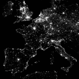
O Operational Line-Scan System (OLS) do Defense Meteorological Program (DMSP) tem uma capacidade exclusiva de detectar fontes de emissão visíveis e de infravermelho próximo (VNIR) à noite.
Essa coleção contém imagens globais de luzes noturnas sem saturação do sensor. O sensor geralmente é operado em uma configuração de alto ganho para permitir a detecção de nuvens iluminadas pela lua. No entanto, com quantização de seis bits e faixa dinâmica limitada, os dados gravados ficam saturados nos núcleos brilhantes dos centros urbanos. Um conjunto limitado de observações com baixa iluminação lunar foi obtido quando o ganho do detector foi definido significativamente abaixo da configuração operacional típica (às vezes por um fator de 100). Os dados esparsos adquiridos em configurações de baixo ganho foram combinados com os dados operacionais adquiridos em configurações de alto ganho para produzir o conjunto de imagens globais de luzes noturnas sem saturação do sensor. Dados de diferentes satélites foram combinados e mesclados no produto final para maximizar a cobertura. Para mais informações, consulte este arquivo readme do provedor.
Processamento de imagens e dados pelo National Geophysical Data Center da NOAA. Dados do DMSP coletados pela Agência de Meteorologia da Força Aérea dos EUA.
Bandas
Tamanho do pixel
927,67 metros
Bandas
| Nome | Mín. | Máx. | Tamanho do pixel | Descrição |
|---|---|---|---|---|
avg_vis |
0* | 6060,6* | metros | Números médios de banda digital de observações com detecção de luz sem nuvens. |
cf_cvg |
0* | 175* | metros | Coberturas sem nuvens, o número total de observações que entraram em cada célula de grade de 30 segundos de arco. Essa imagem pode ser usada para identificar áreas com poucos números de observações em que a qualidade é reduzida. |
Termos de Uso
Termos de Uso
Os dados, as informações e os produtos da NOAA, independentemente do método de entrega, não estão sujeitos a direitos autorais e não têm restrições quanto ao uso posterior pelo público. Depois de obtidos, eles podem ser usados para qualquer finalidade legal. Os dados acima estão em domínio público e são fornecidos sem restrição de uso e distribuição.
Explorar com o Earth Engine
Editor de código (JavaScript)
var dataset = ee.ImageCollection('NOAA/DMSP-OLS/CALIBRATED_LIGHTS_V4')
                  .filter(ee.Filter.date('2010-01-01', '2010-12-31'));
var nighttimeLights = dataset.select('avg_vis');
var nighttimeLightsVis = {
  min: 3.0,
  max: 60.0,
};
Map.setCenter(7.82, 49.1, 4);
Map.addLayer(nighttimeLights, nighttimeLightsVis, 'Nighttime Lights');