- 利用可能なデータセットの期間
- 1999-06-30T00:00:00Z–2002-09-04T00:00:00Z
- データセット プロデューサー
- CIRES の NASA NSIDC DAAC
- タグ
説明
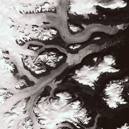
このデータセットは、1999 年から 2002 年の Landsat 7 ETM+ と RADARSAT-1 SAR 画像から作成された、グリーンランド氷床の 15 m 解像度の完全な画像モザイクを提供します。この方法では、画像の雲のマスキング、パンシャープニング、画像のサンプリングとサイズ変更、画像のコア登録を組み合わせて使用します。処理方法の詳細については、Howat(2014 年)をご覧ください。
注
- GIMP DEM または GIMP 2000 Image Mosaic 画像のユーザーは、対応する 15 m の海洋マスク画像である Greenland Ice Mapping Project(GIMP)Land Ice and Ocean Classification Mask を使用して、グリーンランドの海岸線外の領域をマスクすると便利です。
- SAR データは 20 m の解像度で配布されます。Landsat バンド 8 の解像度に合わせて、バイリニア補間によってデータを 15 m にアップサンプリングしました。
バンド
バンド
ピクセルサイズ: さまざま
| 名前 | ピクセルサイズ | 波長 | 説明 |
|---|---|---|---|
B1 |
15 メートル | 0.45 ~ 0.52 μm | Landsat 7 ETM+ 青 |
B2 |
15 メートル | 0.52 ~ 0.60 μm | Landsat 7 ETM+ 緑 |
B3 |
15 メートル | 0.63 ~ 0.69 μm | Landsat 7 ETM+ 赤 |
B4 |
15 メートル | 0.77 ~ 0.90 μm | Landsat 7 ETM+ 近赤外線 |
B5 |
30 メートル | 1.55 ~ 1.75 μm | Landsat 7 ETM+ 短波赤外 1 |
B6_low_gain |
30 メートル | 10.40 ~ 12.50 μm | Landsat 7 ETM+ 低ゲイン熱赤外線 1。このバンドは、ダイナミック レンジが拡大し、放射輝度分解能(感度)が低下しており、高いデジタル番号(DN)値での飽和が少なくなっています。60 m から 30 m にリサンプリングしました。 |
B6_high_gain |
30 メートル | 10.40 ~ 12.50 μm | Landsat 7 ETM+ 高ゲイン熱赤外線 1。このバンドは、ダイナミック レンジが制限されていますが、放射測定分解能(感度)が高くなっています。60 m から 30 m にリサンプリングされました。 |
B7 |
30 メートル | 2.08 ~ 2.35 μm | Landsat 7 ETM+ 短波赤外 2 |
B8 |
15 メートル | 0.52 ~ 0.90 μm | Landsat 7 ETM+ パンクロマティック |
B8_radarsat |
15 メートル | なし | RADARSAT-1 合成開口レーダー振幅画像 |
利用規約
利用規約
これらのデータを使用する条件として、指定された引用を使用してこのデータセットの使用を引用する必要があります。
引用
Howat, I.M.、A. Negrete, B.E. Smith, 2014, The Greenland Ice Mapping Project (GIMP) land classification and surface elevation datasets, The Cryosphere, 8, 1509-1518, doi:10.5194/tc-8-1509-2014 記事の PDF
DOI
Earth Engine で探索する
コードエディタ(JavaScript)
var dataset = ee.Image('OSU/GIMP/2000_IMAGERY_MOSAIC');
var greenlandImage = dataset.select(['B3', 'B2', 'B1']);
var visParams = {
  min: 0.0,
  max: 255.0,
};
Map.setCenter(-29.1605, 70.4, 9);
Map.addLayer(greenlandImage, visParams, 'Greenland Pansharpened Image');