-
2000 年のグリーンランド モザイク - グリーンランド氷床マッピング プロジェクト(GIMP)
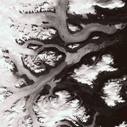
このデータセットは、1999 ~ 2002 年の Landsat 7 ETM+ と RADARSAT-1 SAR の画像から作成された、グリーンランド氷床の完全な 15 m 解像度の画像モザイクを提供します。この手法では、画像の雲マスキング、パンシャープニング、画像サンプリングとサイズ変更などを組み合わせて使用します。 北極 GIMP グリーンランド 画像 NASA 極 -
グリーンランド DEM - グリーンランド マッピング プロジェクト(GIMP)
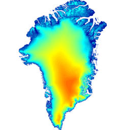
この数値標高モデル(DEM)は、氷床の周辺部と縁部(つまり、平衡線標高より下)の約 82.5°N 以南の ASTER と SPOT-5 の DEM と、氷床内部と最北部の AVHRR フォトクリノメトリー(Scambos と … 北極 標高-地形 GIMP グリーンランド NASA 極 -
グリーンランドの氷と海のマスク - グリーンランド マッピング プロジェクト(GIMP)

このデータセットは、グリーンランド氷床の完全な陸氷と海洋の分類マスクを 15 m で提供します。氷床は、USGS が配布する Landsat 7 Enhanced Thematic Mapper Plus(ETM+)の正射補正されたパンクロマチック(バンド 8)画像と … 北極 氷圏 GIMP グリーンランド 氷 NASA -
MEaSUREs グリーンランド氷床速度: 光学画像からの選択された氷河サイトの速度マップ バージョン 2
このデータセットは、NASA の Making Earth System Data Records for Use in Research Environments(MEaSUREs)プログラムの一部であり、選択された氷河出口領域の月平均速度マップで構成されています。このマップは、Landsat で取得した光学画像のペア間の可視フィーチャーを追跡して生成されます。 北極 氷圏 GIMP グリーンランド 氷 NASA
Datasets tagged greenland in Earth Engine
[null,null,[],[],[]]