Atmosphere-Land Exchange Inverse / Disaggregation of the Atmosphere-Land
Exchange Inverse (ALEXI/DisALEXI)
Model DisALEXI został niedawno przeniesiony do Google Earth Engine w ramach platformy OpenET, a podstawową strukturę modelu ALEXI/DisALEXI opisali Anderson i in. (2012, 2018). Model ewapotranspiracji ALEXI wykorzystuje pomiary różnic w czasie temperatury powierzchni ziemi (LST) z platform geostacjonarnych lub platform na orbitach polarnych o umiarkowanej rozdzielczości do generowania regionalnych map ewapotranspiracji. Następnie DisALEXI rozdziela regionalne dane ALEXI ET na mniejsze skale, korzystając z danych Landsat (30 m; co 2 tygodnie), aby rozróżniać poszczególne pola uprawne i inne elementy krajobrazu.
Informacje dodatkowe
Pasma
Rozmiar piksela 30 metrów
Pasma
Nazwa
Jednostki
Rozmiar piksela
Opis
et
mm
metry
Wartość DisALEXI ET
count
liczba
metry
Liczba wartości bezpłatnych w chmurze
Właściwości obrazu
Właściwości obrazu
Nazwa
Typ
Opis
build_date
CIĄG ZNAKÓW
Data budowy zasobów
cloud_cover_max
LICZBA ZMIENNOPRZECINKOWA O PODWÓJNEJ PRECYZJI
Maksymalna wartość procentowa CLOUD_COVER_LAND dla obrazów Landsat uwzględnionych w interpolacji
kolekcje
CIĄG ZNAKÓW
Lista kolekcji Landsat dla obrazów Landsat uwzględnionych w interpolacji
core_version
CIĄG ZNAKÓW
Wersja podstawowej biblioteki OpenET
end_date
CIĄG ZNAKÓW
Data zakończenia miesiąca
et_reference_band
CIĄG ZNAKÓW
Pasmo w et_reference_source, które zawiera dzienne dane ET referencyjne.
et_reference_resample
CIĄG ZNAKÓW
Tryb interpolacji przestrzennej do ponownego próbkowania dziennych danych ET
et_reference_source
CIĄG ZNAKÓW
Identyfikator kolekcji dziennych danych ET
interp_days
LICZBA ZMIENNOPRZECINKOWA O PODWÓJNEJ PRECYZJI
Maksymalna liczba dni przed i po dacie każdego zdjęcia, które mają być uwzględnione w interpolacji
interp_method
CIĄG ZNAKÓW
Metoda interpolacji między szacunkami modelu Landsat
interp_source_count
LICZBA ZMIENNOPRZECINKOWA O PODWÓJNEJ PRECYZJI
Liczba dostępnych obrazów w zbiorze obrazów źródłowych interpolacji w przypadku miesiąca docelowego
mgrs_tile
CIĄG ZNAKÓW
Identyfikator strefy siatki MGRS
model_name
CIĄG ZNAKÓW
Nazwa modelu OpenET
model_version
CIĄG ZNAKÓW
Wersja modelu OpenET
scale_factor_count
LICZBA ZMIENNOPRZECINKOWA O PODWÓJNEJ PRECYZJI
Współczynnik skalowania, który należy zastosować do zakresu liczby
scale_factor_et
LICZBA ZMIENNOPRZECINKOWA O PODWÓJNEJ PRECYZJI
Współczynnik skalowania, który należy zastosować do pasma ET
Anderson, M. Gao, F., Knipper, K., Hain, C., Dulaney, W., Baldocchi, D .,
Eichelmann, E., Hemes, K., Yang, Y., Medellin-Azuara, J. i Kustas, W.,
2018 r. Ocena zmian w zagospodarowaniu terenu i wykorzystaniu wody w delcie rzeki Sacramento w Kalifornii na podstawie danych z teledetekcji. Remote Sensing, 10(6), s.889.
doi:10.3390/rs10060889
Anderson, M.C., Norman, J.M., Mecikalski, J.R., Otkin, J.A. i Kustas, W.P., 2007. Badanie klimatyczne ewapotranspiracji i stresu wilgotnościowego na terenie kontynentalnych Stanów Zjednoczonych na podstawie termicznego teledetekcji: 1. Formułowanie modelu. Journal of Geophysical Research:
Atmospheres, 112(D10).
doi:10.1029/2006JD007506
Atmosphere-Land Exchange Inverse / Disaggregation of the Atmosphere-Land Exchange Inverse (ALEXI/DisALEXI) DisALEXI został niedawno przeniesiony do Google Earth Engine w ramach OpenET, a podstawową strukturę modelu ALEXI/DisALEXI opisali Anderson i in. (2012, 2018). Model ewapotranspiracji ALEXI wykorzystuje w szczególności różnicowe w czasie dane o powierzchni lądu…
[null,null,[],[[["\u003cp\u003eThe OpenET DisALEXI dataset provides monthly evapotranspiration (ET) data for the contiguous United States (CONUS) at a 30-meter resolution, derived from Landsat and GRIDMET data.\u003c/p\u003e\n"],["\u003cp\u003eDisALEXI, part of the OpenET framework, uses a model based on land surface temperature changes to estimate ET and is further disaggregated using Landsat for finer-scale detail.\u003c/p\u003e\n"],["\u003cp\u003eData is available from January 2008 to December 2023 and is provided by OpenET, Inc.under a CC-BY-4.0 license.\u003c/p\u003e\n"],["\u003cp\u003eThe dataset includes two bands: 'et' representing the DisALEXI ET value in millimeters and 'count' indicating the number of cloud-free values used in the calculation.\u003c/p\u003e\n"],["\u003cp\u003eUsers can explore and analyze this dataset within Google Earth Engine for research, education, and non-profit purposes.\u003c/p\u003e\n"]]],["The OpenET DisALEXI dataset, available from 2001-01-01 to 2023-12-01, provides monthly evapotranspiration (ET) data at a 30-meter resolution. It uses the ALEXI/DisALEXI model, which combines land surface temperature data with Landsat data to estimate ET, including a band with the 'et' value and a 'count' of cloud-free observations. The data can be accessed via Earth Engine using a provided code snippet and is licenced with a CC-BY-4.0 use license.\n"],null,["# OpenET DisALEXI Monthly Evapotranspiration v2.0\n\nDataset Availability\n: 2001-01-01T00:00:00Z--2024-12-01T00:00:00Z\n\nDataset Provider\n:\n\n\n [OpenET, Inc.](https://openetdata.org/)\n\nCadence\n: 1 Month\n\nTags\n:\n[evapotranspiration](/earth-engine/datasets/tags/evapotranspiration) [gridmet-derived](/earth-engine/datasets/tags/gridmet-derived) [landsat-derived](/earth-engine/datasets/tags/landsat-derived) [monthly](/earth-engine/datasets/tags/monthly) [openet](/earth-engine/datasets/tags/openet) [water](/earth-engine/datasets/tags/water) [water-vapor](/earth-engine/datasets/tags/water-vapor) \n\n#### Description\n\nAtmosphere-Land Exchange Inverse / Disaggregation of the Atmosphere-Land\nExchange Inverse (ALEXI/DisALEXI)\n\nDisALEXI was recently ported to Google Earth Engine as part of the OpenET\nframework and the baseline ALEXI/DisALEXI model structure is described by\nAnderson et al. (2012, 2018). The ALEXI evapotranspiration (ET) model\nspecifically uses time differential land surface temperature (LST)\nmeasurements from geostationary or moderate resolution polar orbiting\nplatforms to generate regional ET maps. DisALEXI then disaggregates the\nregional ALEXI ET to finer scales using Landsat data (30 m; biweekly) to\nresolve individual farm fields and other landscape features.\n[Additional information](https://openetdata.org/methodologies/)\n\n### Bands\n\n\n**Pixel Size**\n\n30 meters\n\n**Bands**\n\n| Name | Units | Pixel Size | Description |\n|---------|-------|------------|-----------------------------|\n| `et` | mm | meters | DisALEXI ET value |\n| `count` | count | meters | Number of cloud free values |\n\n### Image Properties\n\n**Image Properties**\n\n| Name | Type | Description |\n|-----------------------|--------|----------------------------------------------------------------------------------------------|\n| build_date | STRING | Date assets were built |\n| cloud_cover_max | DOUBLE | Maximum CLOUD_COVER_LAND percent value for Landsat images included in interpolation |\n| collections | STRING | List of Landsat collections for Landsat images included in the interpolation |\n| core_version | STRING | OpenET core library version |\n| end_date | STRING | End date of month |\n| et_reference_band | STRING | Band in et_reference_source that contains the daily reference ET data |\n| et_reference_resample | STRING | Spatial interpolation mode to resample daily reference ET data |\n| et_reference_source | STRING | Collection ID for the daily reference ET data |\n| interp_days | DOUBLE | Maximum number of days before and after each image date to include in interpolation |\n| interp_method | STRING | Method used to interpolate between Landsat model estimates |\n| interp_source_count | DOUBLE | Number of available images in the interpolation source image collection for the target month |\n| mgrs_tile | STRING | MGRS grid zone ID |\n| model_name | STRING | OpenET model name |\n| model_version | STRING | OpenET model version |\n| scale_factor_count | DOUBLE | Scaling factor that should be applied to the count band |\n| scale_factor_et | DOUBLE | Scaling factor that should be applied to the et band |\n| start_date | STRING | Start date of month |\n\n### Terms of Use\n\n**Terms of Use**\n\n[CC-BY-4.0](https://spdx.org/licenses/CC-BY-4.0.html)\n\n### Citations\n\nCitations:\n\n- Anderson, M., Gao, F., Knipper, K., Hain, C., Dulaney, W., Baldocchi, D .,\n Eichelmann, E., Hemes, K., Yang, Y., Medellin-Azuara, J. and Kustas, W.,\n 2018. Field-scale assessment of land and water use change over the\n California Delta using remote sensing. Remote Sensing, 10(6), p.889.\n [doi:10.3390/rs10060889](https://doi.org/10.3390/rs10060889)\n- Anderson, M.C., Norman, J.M., Mecikalski, J.R., Otkin, J.A. and Kustas,\n W.P., 2007. A climatological study of evapotranspiration and moisture\n stress across the continental United States based on thermal remote\n sensing: 1. Model formulation. Journal of Geophysical Research:\n Atmospheres, 112(D10).\n [doi:10.1029/2006JD007506](https://doi.org/10.1029/2006JD007506)\n\n### DOIs\n\n- \u003chttps://doi.org/10.3390/rs10060889\u003e\n\n### Explore with Earth Engine\n\n| **Important:** Earth Engine is a platform for petabyte-scale scientific analysis and visualization of geospatial datasets, both for public benefit and for business and government users. Earth Engine is free to use for research, education, and nonprofit use. To get started, please [register for Earth Engine access.](https://console.cloud.google.com/earth-engine)\n\n### Code Editor (JavaScript)\n\n```javascript\n
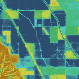
var dataset = ee.ImageCollection('OpenET/DISALEXI/CONUS/GRIDMET/MONTHLY/v2_0')\n .filterDate('2020-01-01', '2021-01-01');\n\n// Compute the annual evapotranspiration (ET) as the sum of the monthly ET\n// images for the year.\nvar et = dataset.select('et').sum();\n\nvar visualization = {\n min: 0,\n max: 1400,\n palette: [\n '9e6212', 'ac7d1d', 'ba9829', 'c8b434', 'd6cf40', 'bed44b', '9fcb51',\n '80c256', '61b95c', '42b062', '45b677', '49bc8d', '4dc2a2', '51c8b8',\n '55cece', '4db4ba', '459aa7', '3d8094', '356681', '2d4c6e',\n ]\n};\n\nMap.setCenter(-100, 38, 5);\n\nMap.addLayer(et, visualization, 'OpenET DisALEXI Annual ET');\n```\n[Open in Code Editor](https://code.earthengine.google.com/?scriptPath=Examples:Datasets/OpenET/OpenET_DISALEXI_CONUS_GRIDMET_MONTHLY_v2_0) \n[OpenET DisALEXI Monthly Evapotranspiration v2.0](/earth-engine/datasets/catalog/OpenET_DISALEXI_CONUS_GRIDMET_MONTHLY_v2_0) \nAtmosphere-Land Exchange Inverse / Disaggregation of the Atmosphere-Land Exchange Inverse (ALEXI/DisALEXI) DisALEXI was recently ported to Google Earth Engine as part of the OpenET framework and the baseline ALEXI/DisALEXI model structure is described by Anderson et al. (2012, 2018). The ALEXI evapotranspiration (ET) model specifically uses time differential land surface ... \nOpenET/DISALEXI/CONUS/GRIDMET/MONTHLY/v2_0, evapotranspiration,gridmet-derived,landsat-derived,monthly,openet,water,water-vapor \n2001-01-01T00:00:00Z/2024-12-01T00:00:00Z \n25 -126 50 -66 \nGoogle Earth Engine \nhttps://developers.google.com/earth-engine/datasets\n\n- [https://doi.org/10.3390/rs10060889](https://doi.org/https://openetdata.org/)\n- [https://doi.org/10.3390/rs10060889](https://doi.org/https://developers.google.com/earth-engine/datasets/catalog/OpenET_DISALEXI_CONUS_GRIDMET_MONTHLY_v2_0)"]]