- Dostępność zbioru danych
- 1999-10-01T00:00:00Z–2024-12-01T00:00:00Z
- Dostawca zbioru danych
- OpenET, Inc.
- Cykl
- 1 miesiąc
- Tagi
Opis
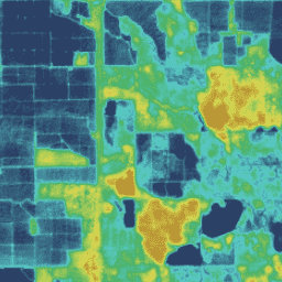
Zbiór danych OpenET zawiera dane satelitarne dotyczące łącznej ilości wody, która jest przenoszona z powierzchni ziemi do atmosfery w procesie ewapotranspiracji (ET). OpenET udostępnia dane ET z wielu modeli opartych na danych satelitarnych, a także oblicza pojedynczą „wartość zespołu” na podstawie zespołu modeli. Modele obecnie uwzględnione w zespole modeli OpenET to ALEXI/DisALEXI, eeMETRIC, geeSEBAL, PT-JPL, SIMS i SSEBop. Wartość ET zespołu OpenET jest obliczana jako średnia zespołu po odfiltrowaniu i usunięciu wartości odstających za pomocą metody medianowego odchylenia bezwzględnego. Wszystkie modele korzystają obecnie z danych satelitarnych Landsat, aby generować dane ET w rozdzielczości 30 m × 30 m (0,22 akra na piksel). Miesięczny zbiór danych ET zawiera dane o całkowitym ET w poszczególnych miesiącach w postaci równoważnej głębokości wody w milimetrach.
Pasma
Rozmiar piksela
30 metrów
Pasma
| Nazwa | Jednostki | Rozmiar piksela | Opis | ||||||||||||||||||||||||||||||||||||||||||||||||||||||||||||||||||||||||||||||||||||||||||||||||
|---|---|---|---|---|---|---|---|---|---|---|---|---|---|---|---|---|---|---|---|---|---|---|---|---|---|---|---|---|---|---|---|---|---|---|---|---|---|---|---|---|---|---|---|---|---|---|---|---|---|---|---|---|---|---|---|---|---|---|---|---|---|---|---|---|---|---|---|---|---|---|---|---|---|---|---|---|---|---|---|---|---|---|---|---|---|---|---|---|---|---|---|---|---|---|---|---|---|---|---|
et_ensemble_mad |
mm | metry | Wartość ET zespołu obliczona jako średnia zespołu po odfiltrowaniu wartości odstających za pomocą medianowego odchylenia bezwzględnego (mad). |
||||||||||||||||||||||||||||||||||||||||||||||||||||||||||||||||||||||||||||||||||||||||||||||||
et_ensemble_mad_min |
mm | metry | Minimalna wartość w zakresie zespołu po odfiltrowaniu wartości odstających za pomocą medianowego odchylenia bezwzględnego (mad). |
||||||||||||||||||||||||||||||||||||||||||||||||||||||||||||||||||||||||||||||||||||||||||||||||
et_ensemble_mad_max |
mm | metry | Maksymalna wartość w zakresie zespołu po odfiltrowaniu wartości odstających za pomocą medianowego odchylenia bezwzględnego (mad). |
||||||||||||||||||||||||||||||||||||||||||||||||||||||||||||||||||||||||||||||||||||||||||||||||
et_ensemble_mad_count |
metry | Liczba modeli użytych do obliczenia wartości ET zespołu po odfiltrowaniu wartości odstających za pomocą medianowego odchylenia bezwzględnego (mad). |
|||||||||||||||||||||||||||||||||||||||||||||||||||||||||||||||||||||||||||||||||||||||||||||||||
et_ensemble_mad_index |
metry | Bitmaska wskazująca, które modele zostały uwzględnione w zespole ET po odfiltrowaniu wartości odstających za pomocą medianowego odchylenia bezwzględnego (mad). |
|||||||||||||||||||||||||||||||||||||||||||||||||||||||||||||||||||||||||||||||||||||||||||||||||
et_ensemble_sam |
mm | metry | prosta średnia arytmetyczna (sam) wszystkich 6 modeli w zespole OpenETmodel, |
||||||||||||||||||||||||||||||||||||||||||||||||||||||||||||||||||||||||||||||||||||||||||||||||
Właściwości obrazu
Właściwości obrazu
| Nazwa | Typ | Opis |
|---|---|---|
| build_date | CIĄG ZNAKÓW | Data budowy zasobów |
| core_version | CIĄG ZNAKÓW | Wersja podstawowej biblioteki OpenET |
| end_date | CIĄG ZNAKÓW | Data zakończenia miesiąca |
| mgrs_tile | CIĄG ZNAKÓW | Identyfikator strefy siatki MGRS |
| start_date | CIĄG ZNAKÓW | Data rozpoczęcia miesiąca |
Warunki korzystania z usługi
Warunki korzystania z usługi
Cytaty
Melton, F., Huntington, J., Grimm, R., Herring, J., Hall, M., Rollison, D., Erickson, T., Allen, R., Anderson, M. Fisher, J., Kilic, A., Senay, G., volk, J., Hain, C., Johnson, L., Ruhoff, A., Blankenau, P., Bromley, M., Carrara, W., Daudert, B., Doherty, C., Dunkerly, C., Friedrichs, M., Guzman, A., Halverson, G., Hansen, J., Harding, J., Kang, Y., Ketchum, D., Minor, B., Morton, C., Revelle, P., Ortega-Salazar, S., Ott, T., Ozdogon, M., Schull, M., Wang, T., Yang, Y., Anderson, R., 2021. OpenET: wypełnianie krytycznej luki w danych dotyczących gospodarki wodnej w zachodnich stanach USA. Journal of the American Water Resources Association, 2 listopada 2021 r. doi:10.1111/1752-1688.12956
DOI
Odkrywanie za pomocą Earth Engine
Edytor kodu (JavaScript)
var dataset = ee.ImageCollection('OpenET/ENSEMBLE/CONUS/GRIDMET/MONTHLY/v2_0')
  .filterDate('2020-01-01', '2021-01-01');

// Compute the annual evapotranspiration (ET) as the sum of the monthly ET
// images for the year.
var et = dataset.select('et_ensemble_mad').sum();

var visualization = {
  min: 0,
  max: 1400,
  palette: [
    '9e6212', 'ac7d1d', 'ba9829', 'c8b434', 'd6cf40', 'bed44b', '9fcb51',
    '80c256', '61b95c', '42b062', '45b677', '49bc8d', '4dc2a2', '51c8b8',
    '55cece', '4db4ba', '459aa7', '3d8094', '356681', '2d4c6e',
  ]
};

Map.setCenter(-100, 38, 5);

Map.addLayer(et, visualization, 'OpenET Ensemble Annual ET');