- Dostępność zbioru danych
- 2001-01-01T00:00:00Z–2002-01-01T00:00:00Z
- Dostawca zbioru danych
- EnvirometriX Ltd
- Tagi
Opis
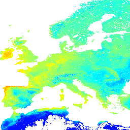
Prognozowana miesięczna mediana potencjalnej naturalnej roślinności FAPAR (na podstawie PROB-V FAPAR 2014–2017). Opis
Aby uzyskać dostęp do map i wyświetlać je poza Earth Engine, skorzystaj z tej strony.
Jeśli zauważysz błąd, artefakt lub niespójność na mapach LandGIS lub masz pytanie, skorzystaj z tych kanałów:
Pasma
Pasma
Rozmiar piksela: 1000 m (wszystkie pasma)
| Nazwa | Jednostki | Min. | Maks. | Rozmiar piksela | Opis |
|---|---|---|---|---|---|
jan |
Ułamek | 0* | 220* | 1 000 metrów | Jan Potential FAPAR monthly |
feb |
Ułamek | 0* | 220* | 1 000 metrów | Feb Potential FAPAR monthly |
mar |
Ułamek | 0* | 220* | 1 000 metrów | Mar Potential FAPAR monthly |
apr |
Ułamek | 0* | 220* | 1 000 metrów | Apr Potential FAPAR monthly |
may |
Ułamek | 0* | 220* | 1 000 metrów | May Potential FAPAR monthly |
jun |
Ułamek | 0* | 220* | 1 000 metrów | Potencjalny miesięczny FAPAR w czerwcu |
jul |
Ułamek | 0* | 220* | 1 000 metrów | Potencjalny miesięczny FAPAR w lipcu |
aug |
Ułamek | 0* | 220* | 1 000 metrów | Aug Potential FAPAR monthly |
sep |
Ułamek | 0* | 220* | 1 000 metrów | Sep Potential FAPAR monthly |
oct |
Ułamek | 0* | 220* | 1 000 metrów | Potencjalny miesięczny FAPAR w październiku |
nov |
Ułamek | 0* | 220* | 1 000 metrów | Listopad – potencjalny miesięczny FAPAR |
dec |
Ułamek | 0* | 220* | 1 000 metrów | Dec Potential FAPAR monthly |
annual |
Ułamek | 0* | 220* | 1 000 metrów | Anuual Potential FAPAR monthly |
annualdiff |
Ułamek | 0* | 220* | 1 000 metrów | Różnica roczna potencjalnego miesięcznego FAPAR |
Warunki korzystania z usługi
Warunki korzystania z usługi
Jest to czytelne dla człowieka podsumowanie licencji (nie zastępuje jej).
Wolno: Udostępnianie — kopiuj i rozpowszechniaj materiał w dowolnym medium i formacie; Adaptacje — remiksuj, zmieniaj i twórz na bazie materiału dla dowolnego celu, także komercyjnego.
Ta licencja jest odpowiednia dla wolnych dzieł kultury. Licencjodawca nie może odwołać udzielonych praw, o ile są przestrzegane warunki licencji.
Na tych warunkach: Uznanie autorstwa – utwór należy odpowiednio oznaczyć, podać link do licencji i wskazać, jeśli zostały dokonane w nim zmiany. Możesz to zrobić w dowolny rozsądny sposób, o ile nie sugeruje to udzielania prze licencjodawcę poparcia dla Ciebie lub sposobu, w jaki wykorzystujesz ten utwór.
ShareAlike – jeśli remiksujesz, przekształcasz lub tworzysz na podstawie materiału, musisz rozpowszechniać swoje dzieło na tej samej licencji co oryginał.
Brak dodatkowych ograniczeń — nie możesz stosować warunków prawnych ani środków technicznych, które ograniczają innym osobom możliwość korzystania z uprawnień licencyjnych.
Cytaty
Hengl T, Walsh MG, Sanderman J, Wheeler I, Harrison SP, Prentice IC. (2018) Global Mapping of Potential Natural Vegetation: An Assessment of Machine Learning Algorithms for Estimating Land Potential. PeerJ Preprints. 10.7287/peerj.preprints.26811v5
DOI
Odkrywaj za pomocą Earth Engine
Edytor kodu (JavaScript)
var dataset = ee.Image('OpenLandMap/PNV/PNV_FAPAR_PROBA-V_D/v01');

var visualization = {
  bands: ['jan'],
  min: 0.0,
  max: 220.0,
  palette: ['0000ff', '00ffff', 'ffff00', 'ff0000']
};

Map.centerObject(dataset);

Map.addLayer(dataset, visualization, 'Potential FAPAR monthly');