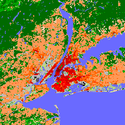
С момента своего введения в 2012 году локальные климатические зоны (LCZ) стали новым стандартом для характеристики городских ландшафтов, обеспечивая комплексный подход к классификации, учитывающий микромасштабный земельный покров и связанные с ним физические свойства.
Эта глобальная карта локальных климатических зон с разрешением 100 м, репрезентативная для номинального 2018 года, составлена на основе нескольких наборов данных наблюдений за Землей и экспертных меток классов LCZ. Для большинства пользователей рекомендуется диапазон LCZ_Filter. Другой классификационный диапазон, LCZ, предоставляется только для расчета диапазона LCZ_Probability.
Схема LCZ дополняет другие схемы землепользования/земельного покрова, фокусируясь на типах городских и сельских ландшафтов, которые могут быть описаны любым из 17 классов схемы LCZ. Из 17 классов LCZ 10 отражают «застроенную» среду, и каждый тип LCZ связан с общими числовыми описаниями ключевых параметров городского полога, критически важных для моделирования реакции атмосферы на урбанизацию. Кроме того, поскольку LCZ изначально разрабатывались как новая структура для исследований городских островов тепла, они также содержат ограниченный набор (7) «естественных» классов земельного покрова, которые могут использоваться в качестве «контрольных» или «естественных эталонных» территорий.
Поскольку эти семь природных классов в схеме LCZ не могут охватить всю неоднородность существующих природных экосистем мира, мы советуем пользователям — при необходимости — объединять построенные классы LCZ с любым другим продуктом земельного покрова, который обеспечивает более широкий диапазон естественных классов земельного покрова.
Необработанная пиксельная глобальная карта LCZ с классами LCZ
LCZ_Filter
метров
Рекомендуемая глобальная карта LCZ с классами LCZ. Метки LCZ получены после применения морфологического гауссовского фильтра, описанного в работе Демузере и др. (2020).
LCZ_Probability
%
метров
Вероятностный слой, который определяет частоту выбора модальной LCZ для каждого пикселя (например, вероятность 60% означает, что класс модальной LCZ был выбран 30 раз из 50 моделей LCZ). Это вероятность, основанная на пикселях, полученная из LCZ-слоя.
Демузере М.; Киттнер Дж.; Мартилли А.; Миллс Г.; Мёде К.; Стюарт И.Д.; ван Влит Дж.; Бехтель Б. Глобальная карта локальных климатических зон для моделирования экосистемы Земли и изучения окружающей среды в масштабах городов. Earth System Science Data 2022, 14, том 8: 3835–3873. doi:10.5194/essd-14-3835-2022
С момента своего появления в 2012 году локальные климатические зоны (LCZ) стали новым стандартом для характеристики городских ландшафтов, предлагая комплексный подход к классификации, учитывающий микромасштабный ландшафтный покров и связанные с ним физические свойства. Эта глобальная карта локальных климатических зон с разрешением 100 м и репрезентативной для номинального года…
[null,null,[],[[["\u003cp\u003eThis dataset provides a global map of Local Climate Zones (LCZs) at a 100m resolution for the nominal year 2018.\u003c/p\u003e\n"],["\u003cp\u003eLCZs offer a standardized classification of urban landscapes, incorporating micro-scale land cover and physical properties for climate studies.\u003c/p\u003e\n"],["\u003cp\u003eThe dataset includes 17 LCZ classes, representing both built environments (10) and natural land cover types (7).\u003c/p\u003e\n"],["\u003cp\u003eThe 'LCZ_Filter' band is recommended for general use, offering a morphologically filtered LCZ classification.\u003c/p\u003e\n"],["\u003cp\u003eUsers may combine the built LCZ classes with other land cover products for more detailed analyses of natural ecosystems.\u003c/p\u003e\n"]]],[],null,["# Global map of Local Climate Zones, latest version\n\nDataset Availability\n: 2018-01-01T00:00:00Z--2019-01-01T00:00:00Z\n\nDataset Provider\n:\n\n\n [Bochum Urban Climate Lab](https://lcz-generator.rub.de/global-lcz-map)\n\nTags\n:\n[climate](/earth-engine/datasets/tags/climate) [landcover](/earth-engine/datasets/tags/landcover) [landuse-landcover](/earth-engine/datasets/tags/landuse-landcover) [urban](/earth-engine/datasets/tags/urban) \n\n#### Description\n\nSince their introduction in 2012, Local Climate Zones (LCZs) emerged as\na new standard for characterizing urban landscapes, providing a holistic\nclassification approach that takes into account micro-scale land-cover and\nassociated physical properties.\n\nThis global map of Local Climate Zones, at 100m pixel size and\nrepresentative for the nominal year 2018, is derived from multiple earth\nobservation datasets and expert LCZ class labels. LCZ_Filter is the\nrecommended band for most users. The other classification band, LCZ, is\nonly provided as it is used to calculate the LCZ_Probability band.\n\nThe LCZ scheme complements other land use / land cover schemes by\nits focus on urban and rural landscape types, which can be described by\nany of the 17 classes in the LCZ scheme. Out of the 17 LCZ classes, 10\nreflect the 'built' environment, and each LCZ type is associated with\ngeneric numerical descriptions of key urban canopy parameters critical to\nmodel atmospheric responses to urbanisation. In addition, since LCZs were\noriginally designed as a new framework for urban heat island studies, they\nalso contain a limited set (7) of 'natural' land-cover classes that can be\nused as 'control' or 'natural reference' areas.\n\nAs these seven natural classes in the LCZ scheme can not capture the\nheterogeneity of the world's existing natural ecosystems, we advise\nusers - if required - to combine the built LCZ classes with any other\nland-cover product that provides a wider range of natural land-cover\nclasses.\n\nSee also:\n\n- [LCZ Typology](https://doi.org/10.1175/BAMS-D-11-00019.1)\n\n- [Global map of LCZs - paper](https://doi.org/10.5194/essd-14-3835-2022)\n\n- [Global map of LCZs - dataset](https://doi.org/10.5281/zenodo.6364593)\n\n- [LCZ Gaussian filtering](https://doi.org/10.1038/s41597-020-00605-z)\n\n### Bands\n\n\n**Pixel Size**\n\n100 meters\n\n**Bands**\n\n| Name | Units | Pixel Size | Description |\n|-------------------|-------|------------|----------------------------------------------------------------------------------------------------------------------------------------------------------------------------------------------------------------------------------------------------|\n| `LCZ` | | meters | The raw, pixel-based global LCZ map with LCZ classes |\n| `LCZ_Filter` | | meters | The recommended global LCZ map with LCZ classes. LCZ labels are obtained after applying the morphological Gaussian filter described in Demuzere et al. (2020) |\n| `LCZ_Probability` | % | meters | A probability layer that identifies how often the modal LCZ was chosen per pixel (e.g. a probability of 60% means that the modal LCZ class was mapped 30 times out of 50 LCZ models). This is a pixel-based probability derived from the LCZ layer |\n\n**LCZ Class Table**\n\n| Value | Color | Description |\n|-------|---------|----------------------------|\n| 1 | #8c0000 | Compact highrise |\n| 2 | #d10000 | Compact midrise |\n| 3 | #ff0000 | Compact lowrise |\n| 4 | #bf4d00 | Open highrise |\n| 5 | #ff6600 | Open midrise |\n| 6 | #ff9955 | Open lowrise |\n| 7 | #faee05 | Lightweight lowrise |\n| 8 | #bcbcbc | Large lowrise |\n| 9 | #ffccaa | Sparsely built |\n| 10 | #555555 | Heavy industry |\n| 11 | #006a00 | Dense Trees (LCZ A) |\n| 12 | #00aa00 | Scattered Trees (LCZ B) |\n| 13 | #648525 | Bush, scrub (LCZ C) |\n| 14 | #b9db79 | Low plants (LCZ D) |\n| 15 | #000000 | Bare rock or paved (LCZ E) |\n| 16 | #fbf7ae | Bare soil or sand (LCZ F) |\n| 17 | #6a6aff | Water (LCZ G) |\n\n**LCZ_Filter Class Table**\n\n| Value | Color | Description |\n|-------|---------|----------------------------|\n| 1 | #8c0000 | Compact highrise |\n| 2 | #d10000 | Compact midrise |\n| 3 | #ff0000 | Compact lowrise |\n| 4 | #bf4d00 | Open highrise |\n| 5 | #ff6600 | Open midrise |\n| 6 | #ff9955 | Open lowrise |\n| 7 | #faee05 | Lightweight lowrise |\n| 8 | #bcbcbc | Large lowrise |\n| 9 | #ffccaa | Sparsely built |\n| 10 | #555555 | Heavy industry |\n| 11 | #006a00 | Dense Trees (LCZ A) |\n| 12 | #00aa00 | Scattered Trees (LCZ B) |\n| 13 | #648525 | Bush, scrub (LCZ C) |\n| 14 | #b9db79 | Low plants (LCZ D) |\n| 15 | #000000 | Bare rock or paved (LCZ E) |\n| 16 | #fbf7ae | Bare soil or sand (LCZ F) |\n| 17 | #6a6aff | Water (LCZ G) |\n\n### Terms of Use\n\n**Terms of Use**\n\n[CC-BY-4.0](https://spdx.org/licenses/CC-BY-4.0.html)\n\n### Citations\n\nCitations:\n\n- Demuzere M.; Kittner J.; Martilli A.; Mills, G.; Moede, C.; Stewart, I.D.; van Vliet, J.; Bechtel, B.\n A global map of local climate zones to support earth system modelling and urban-scale environmental science.\n Earth System Science Data 2022, 14 Volume 8: 3835-3873.\n [doi:10.5194/essd-14-3835-2022](https://doi.org/10.5194/essd-14-3835-2022)\n\n### DOIs\n\n- \u003chttps://doi.org/10.5281/zenodo.6364593\u003e\n\n### Explore with Earth Engine\n\n| **Important:** Earth Engine is a platform for petabyte-scale scientific analysis and visualization of geospatial datasets, both for public benefit and for business and government users. Earth Engine is free to use for research, education, and nonprofit use. To get started, please [register for Earth Engine access.](https://console.cloud.google.com/earth-engine)\n\n### Code Editor (JavaScript)\n\n```javascript\nvar dataset = ee.ImageCollection('RUB/RUBCLIM/LCZ/global_lcz_map/latest')\n .mosaic();\n\nvar visualization = {\n bands: ['LCZ_Filter'],\n min: 1,\n max: 17,\n palette: [\n '8c0000','d10000','ff0000','bf4d00','ff6600',\n 'ff9955','faee05','bcbcbc','ffccaa','555555',\n '006a00','00aa00','648525','b9db79','000000',\n 'fbf7ae','6a6aff'\n ]\n};\n\nMap.setCenter(7.26, 51.44, 6);\nMap.addLayer(dataset, visualization, 'LCZ_Filter');\n```\n[Open in Code Editor](https://code.earthengine.google.com/?scriptPath=Examples:Datasets/RUB/RUB_RUBCLIM_LCZ_global_lcz_map_latest) \n[Global map of Local Climate Zones, latest version](/earth-engine/datasets/catalog/RUB_RUBCLIM_LCZ_global_lcz_map_latest) \nSince their introduction in 2012, Local Climate Zones (LCZs) emerged as a new standard for characterizing urban landscapes, providing a holistic classification approach that takes into account micro-scale land-cover and associated physical properties. This global map of Local Climate Zones, at 100m pixel size and representative for the nominal year ... \nRUB/RUBCLIM/LCZ/global_lcz_map/latest, climate,landcover,landuse-landcover,urban \n2018-01-01T00:00:00Z/2019-01-01T00:00:00Z \n-90 -180 90 180 \nGoogle Earth Engine \nhttps://developers.google.com/earth-engine/datasets\n\n- [https://doi.org/10.5281/zenodo.6364593](https://doi.org/https://lcz-generator.rub.de/global-lcz-map)\n- [https://doi.org/10.5281/zenodo.6364593](https://doi.org/https://developers.google.com/earth-engine/datasets/catalog/RUB_RUBCLIM_LCZ_global_lcz_map_latest)"]]