- ডেটাসেটের উপলভ্যতা
- 2016-01-01T00:00:00Z–2017-01-02T00:00:00Z
- ডেটাসেট প্রযোজক
- মার্কিন যুক্তরাষ্ট্রের আদমশুমারি ব্যুরো
- ট্যাগ
বিবরণ
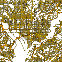
এই মার্কিন যুক্তরাষ্ট্রের আদমশুমারি ব্যুরো TIGER ডেটাসেটে ২০১৬ সালের প্রকাশনা থেকে সমস্ত রাস্তার অংশ রয়েছে, যার মধ্যে মার্কিন যুক্তরাষ্ট্র, কলম্বিয়া জেলা, পুয়ের্তো রিকো এবং দ্বীপ অঞ্চলগুলিকে কভার করে ১ কোটি ৯০ লক্ষেরও বেশি পৃথক লাইন বৈশিষ্ট্য রয়েছে। প্রতিটি বৈশিষ্ট্য একটি রাস্তার অংশের জ্যামিতি (কমপক্ষে একটি ছেদনের সাথে সংযুক্ত একটি একক নৌযানযোগ্য রৈখিক পথ) প্রতিনিধিত্ব করে।
TIGER 2016 এর সকল পণ্যের সম্পূর্ণ প্রযুক্তিগত বিবরণের জন্য, TIGER এর প্রযুক্তিগত ডকুমেন্টেশন দেখুন।
টেবিল স্কিমা
টেবিল স্কিমা
| নাম | আদর্শ | বিবরণ |
|---|---|---|
| পূর্ণ নাম | স্ট্রিং | মানুষের পঠনযোগ্য রাস্তার নাম |
| রৈখিক | স্ট্রিং | অন্যান্য TIGER পণ্যগুলিতে এই সারিটি উল্লেখ করতে ব্যবহৃত প্রাথমিক শনাক্তকারী |
| এমটিএফসিসি | স্ট্রিং | রাস্তার অগ্রাধিকার কোড , যা প্রতিনিধিত্ব করে, যেমন, প্রাথমিক, দ্বিতীয়, স্থানীয়, ইত্যাদি। |
| rtyp সম্পর্কে | স্ট্রিং | রুট টাইপ কোড , |
ব্যবহারের শর্তাবলী
ব্যবহারের শর্তাবলী
মার্কিন আদমশুমারি ব্যুরো তার কিছু পাবলিক ডেটা একটি অ্যাপ্লিকেশন প্রোগ্রামিং ইন্টারফেস (API) এর মাধ্যমে মেশিন-পঠনযোগ্য ফর্ম্যাটে অফার করে। API এর মাধ্যমে উপলব্ধ সমস্ত বিষয়বস্তু, ডকুমেন্টেশন, কোড এবং সম্পর্কিত উপকরণ এই শর্তাবলীর অধীন।
উদ্ধৃতি
ডেটা সেট থেকে প্রাপ্ত যেকোনো প্রতিবেদন, প্রকাশনা, নতুন ডেটা সেট, প্রাপ্ত পণ্য বা পরিষেবা তৈরির জন্য ব্যবহারকারীদের মার্কিন আদমশুমারি ব্যুরো উল্লেখ করা উচিত।
আর্থ ইঞ্জিনের সাহায্যে ঘুরে দেখুন
কোড এডিটর (জাভাস্ক্রিপ্ট)
var dataset = ee.FeatureCollection('TIGER/2016/Roads');
var roads = dataset.style({color: '#4285F4', width: 1});
Map.setCenter(-73.99172, 40.74101, 12);
Map.addLayer(roads, {}, 'TIGER/2016/Roads');
একটি FeatureView হিসেবে ভিজ্যুয়ালাইজ করুন
FeatureView হল FeatureCollection এর একটি ত্বরিত উপস্থাপনা যা কেবলমাত্র দেখার জন্য। আরও বিস্তারিত জানার জন্য, FeatureView ডকুমেন্টেশনটি দেখুন।
কোড এডিটর (জাভাস্ক্রিপ্ট)
var fvLayer = ui.Map.FeatureViewLayer('TIGER/2016/Roads_FeatureView');

var visParams = {
  color: '4285f4'
};

fvLayer.setVisParams(visParams);
fvLayer.setName('US census roads');

Map.setCenter(-73.99172, 40.74101, 14);
Map.add(fvLayer);