Ten zbiór danych TIGER opracowany przez amerykańskie Biuro Spisu Ludności zawiera wszystkie odcinki dróg z wersji z 2016 roku, czyli ponad 19 milionów pojedynczych linii obejmujących Stany Zjednoczone, Dystrykt Kolumbii, Portoryko i obszary wyspiarskie.
Każda funkcja reprezentuje geometrię odcinka drogi (pojedyncza ścieżka liniowa, po której można się poruszać, połączona z co najmniej jednym skrzyżowaniem).
Amerykańskie Biuro Spisu Ludności udostępnia niektóre ze swoich publicznych danych w formacie czytelnym dla maszyn za pomocą interfejsu API. Cała zawartość, dokumentacja, kod i powiązane materiały udostępniane za pomocą interfejsu API podlegają niniejszym warunkom.
Cytaty
Cytowania:
W przypadku tworzenia raportów, publikacji, nowych zbiorów danych, produktów pochodnych lub usług na podstawie zbioru danych użytkownicy powinni cytować US Census Bureau.
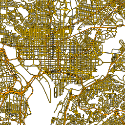
Ten zbiór danych TIGER amerykańskiego Biura Spisu Ludności zawiera wszystkie odcinki dróg z wersji z 2016 r., czyli ponad 19 mln linii obejmujących Stany Zjednoczone, Dystrykt Kolumbii, Portoryko i obszary wyspiarskie. Każda funkcja reprezentuje geometrię odcinka drogi (pojedyncza ścieżka liniowa, po której można się poruszać, połączona z …
[null,null,[],[[["\u003cp\u003eThe TIGER/2016/Roads dataset provides road segment data for the United States, D.C., Puerto Rico, and Island Areas from the 2016 US Census Bureau release.\u003c/p\u003e\n"],["\u003cp\u003eThis dataset contains over 19 million line features, each representing a navigable road segment.\u003c/p\u003e\n"],["\u003cp\u003eRoad features include attributes like name, priority code (e.g., primary, secondary), and route type.\u003c/p\u003e\n"],["\u003cp\u003eUsers should cite the US Census Bureau when using this data in reports or publications.\u003c/p\u003e\n"],["\u003cp\u003eThe dataset is accessible through Earth Engine for analysis and visualization.\u003c/p\u003e\n"]]],[],null,["# TIGER: US Census Roads\n\nDataset Availability\n: 2016-01-01T00:00:00Z--2017-01-02T00:00:00Z\n\nDataset Provider\n:\n\n\n [United States Census Bureau](https://www.census.gov/programs-surveys/geography/guidance/tiger-data-products-guide.html)\n\nTags\n:\n[census](/earth-engine/datasets/tags/census) [infrastructure-boundaries](/earth-engine/datasets/tags/infrastructure-boundaries) [roads](/earth-engine/datasets/tags/roads) [table](/earth-engine/datasets/tags/table) [tiger](/earth-engine/datasets/tags/tiger) [us](/earth-engine/datasets/tags/us) \n\n#### Description\n\nThis United States Census Bureau TIGER dataset contains all road segments\nfrom the 2016 release, containing more than 19 million individual\nline features covering the United States, the District of Columbia,\nPuerto Rico, and the [Island Areas](https://www.census.gov/newsroom/releases/archives/2010_census/press-kits/island-areas.html).\nEach feature represents a road segment geometry (a single navigable\nlinear path connected to at least one intersection).\n\nFor full technical details on all TIGER 2016 products, see the [TIGER\ntechnical documentation](https://www2.census.gov/geo/pdfs/maps-data/data/tiger/tgrshp2016/TGRSHP2016_TechDoc.pdf).\n\n### Table Schema\n\n**Table Schema**\n\n| Name | Type | Description |\n|----------|--------|-------------------------------------------------------------------------------------------------------------------------------------------------------------|\n| fullname | STRING | A human-readable road name |\n| linearid | STRING | The primary identifier used to refer to this row in other TIGER products |\n| mtfcc | STRING | The road [priority code](https://www.census.gov/library/reference/code-lists/mt-feature-class-codes.html), representing, e.g., primary, second, local, etc. |\n| rttyp | STRING | The route [type code](https://www.census.gov/library/reference/code-lists/route-type-codes.html), |\n\n### Terms of Use\n\n**Terms of Use**\n\nThe U.S. Census Bureau offers some of its public data\nin machine-readable format via an Application Programming Interface\n(API). All of the content, documentation, code and related materials\nmade available through the API are subject to [these terms and\nconditions](https://www.census.gov/data/developers/about/terms-of-service.html).\n\n### Citations\n\nCitations:\n\n- For the creation of any reports, publications, new data sets, derived\n products, or services resulting from the data set, users should\n [cite the US Census Bureau](https://www.census.gov/about/policies/citation.html).\n\n### Explore with Earth Engine\n\n| **Important:** Earth Engine is a platform for petabyte-scale scientific analysis and visualization of geospatial datasets, both for public benefit and for business and government users. Earth Engine is free to use for research, education, and nonprofit use. To get started, please [register for Earth Engine access.](https://console.cloud.google.com/earth-engine)\n\n### Code Editor (JavaScript)\n\n```javascript\nvar dataset = ee.FeatureCollection('TIGER/2016/Roads');\nvar roads = dataset.style({color: '#4285F4', width: 1});\nMap.setCenter(-73.99172, 40.74101, 12);\nMap.addLayer(roads, {}, 'TIGER/2016/Roads');\n```\n[Open in Code Editor](https://code.earthengine.google.com/?scriptPath=Examples:Datasets/TIGER/TIGER_2016_Roads)\n\n### Visualize as a FeatureView\n\n\nA `FeatureView` is a view-only, accelerated representation of a\n`FeatureCollection`. For more details, visit the\n[`FeatureView` documentation.](/earth-engine/guides/featureview_overview)\n| **Important:** Earth Engine is a platform for petabyte-scale scientific analysis and visualization of geospatial datasets, both for public benefit and for business and government users. Earth Engine is free to use for research, education, and nonprofit use. To get started, please [register for Earth Engine access.](https://console.cloud.google.com/earth-engine)\n\n### Code Editor (JavaScript)\n\n```javascript\nvar fvLayer = ui.Map.FeatureViewLayer('TIGER/2016/Roads_FeatureView');\n\nvar visParams = {\n color: '4285f4'\n};\n\nfvLayer.setVisParams(visParams);\nfvLayer.setName('US census roads');\n\nMap.setCenter(-73.99172, 40.74101, 14);\nMap.add(fvLayer);\n```\n[Open in Code Editor](https://code.earthengine.google.com/?scriptPath=Examples:Datasets/TIGER/TIGER_2016_Roads_FeatureView) \n[TIGER: US Census Roads](/earth-engine/datasets/catalog/TIGER_2016_Roads) \nThis United States Census Bureau TIGER dataset contains all road segments from the 2016 release, containing more than 19 million individual line features covering the United States, the District of Columbia, Puerto Rico, and the Island Areas. Each feature represents a road segment geometry (a single navigable linear path connected ... \nTIGER/2016/Roads, census,infrastructure-boundaries,roads,table,tiger,us \n2016-01-01T00:00:00Z/2017-01-02T00:00:00Z \n-14.69 -180 71.567 -64.435 \nGoogle Earth Engine \nhttps://developers.google.com/earth-engine/datasets\n\n- [](https://doi.org/https://www.census.gov/programs-surveys/geography/guidance/tiger-data-products-guide.html)\n- [](https://doi.org/https://developers.google.com/earth-engine/datasets/catalog/TIGER_2016_Roads)"]]