-
GHSL: Global settlement characteristics (10 m) 2018 (P2023A)
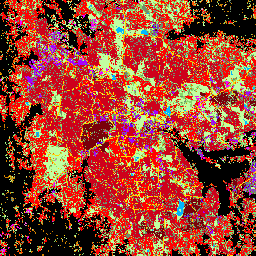
Ten przestrzenny zbiór danych rastrowych wyznacza obszary zamieszkane przez ludzi w rozdzielczości 10 m i opisuje ich wewnętrzną charakterystykę pod względem funkcjonalnych i związanych z wysokością elementów środowiska zabudowanego. Więcej informacji o produktach danych GHSL znajdziesz w raporcie GHSL Data Package 2023… building built builtup copernicus ghsl height -
TIGER: drogi w spisie ludności USA
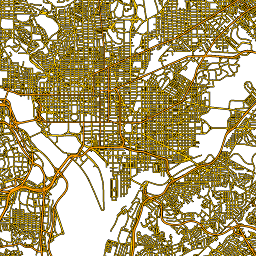
Ten zbiór danych TIGER amerykańskiego Biura Spisu Ludności zawiera wszystkie odcinki dróg z wersji z 2016 r., czyli ponad 19 mln linii obejmujących Stany Zjednoczone, Dystrykt Kolumbii, Portoryko i terytoria wyspiarskie. Każda cecha reprezentuje geometrię odcinka drogi (… census infrastructure-boundaries roads table tiger us
Datasets tagged roads in Earth Engine
[null,null,[],[],["The content describes two spatial datasets. The first, GHSL, delineates human settlements at 10m resolution, detailing functional and height-related aspects of the built environment. The second, TIGER, from the US Census Bureau, contains over 19 million road segments from the 2016 release, covering the US, District of Columbia, Puerto Rico, and Island Areas, each represented by a road segment geometry.\n"]]