- Dostępność zbioru danych
- 2018-01-01T00:00:00Z–2018-12-31T00:00:00Z
- Dostawca zbioru danych
- EC JRC
- Tagi
Opis
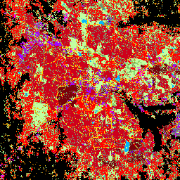
Ten przestrzenny zbiór danych rastrowych wyznacza obszary zamieszkane przez ludzi w rozdzielczości 10 m i opisuje ich wewnętrzne cechy pod względem funkcjonalnych i związanych z wysokością elementów środowiska zabudowanego.
Więcej informacji o produktach danych GHSL znajdziesz w raporcie GHSL Data Package 2023.
Projekt Global Human Settlement Layer (GHSL) jest wspierany przez Komisję Europejską, Wspólne Centrum Badawcze oraz Dyrekcję Generalną ds. Polityki Regionalnej i Miejskiej.
Pasma
Rozmiar piksela
10 metrów
Pasma
| Nazwa | Rozmiar piksela | Opis |
|---|---|---|
built_characteristics |
metry | Charakterystyka rozliczenia |
Tabela klas built_characteristics
| Wartość | Kolor | Opis |
|---|---|---|
| 1 | #718c6c | otwarte przestrzenie, powierzchnie z niską roślinnością, |
| 2 | #8ad86b | otwarte przestrzenie, średnie powierzchnie roślinne, |
| 3 | #c1ffa1 | otwarte przestrzenie, powierzchnie z wysoką roślinnością, |
| 4 | #01b7ff | otwarte przestrzenie, powierzchnie wody, |
| 5 | #ffd501 | otwarte przestrzenie, nawierzchnie dróg, |
| 11 | #d28200 | built spaces, residential, building height <= 3m |
| 12 | #fe5900 | obszary zabudowane, mieszkalne, 3 m < wysokość budynku <= 6 m |
| 13 | #ff0101 | obszary zabudowane, mieszkalne, 6 m < wysokość budynku <= 15 m |
| 14 | #ce001b | obszary zabudowane, mieszkalne, 15 m < wysokość budynku <= 30 m |
| 15 | #7a000a | obszary zabudowane, mieszkalne, wysokość budynku > 30 m |
| 21 | #ff9ff4 | obszary zabudowane, niemieszkalne, wysokość budynku <= 3 m |
| 22 | #ff67e4 | obszary zabudowane, niemieszkalne, 3 m < wysokość budynku <= 6 m |
| 23 | #f701ff | obszary zabudowane, niemieszkalne, 6 m < wysokość budynku <= 15 m |
| 24 | #a601ff | obszary zabudowane, niemieszkalne, 15 m < wysokość budynku <= 30 m; |
| 25 | #6e00fe | obszary zabudowane, niemieszkalne, wysokość budynku > 30 m |
Warunki korzystania z usługi
Warunki korzystania z usługi
GHSL został opracowany przez Wspólne Centrum Badawcze Komisji Europejskiej jako otwarte i bezpłatne dane. Ponowne wykorzystanie jest dozwolone pod warunkiem podania źródła. Więcej informacji znajdziesz w warunkach korzystania (European Commission Reuse and Copyright Notice).
Cytaty
Zbiór danych : Pesaresi, Martino; Politis, Panagiotis (2023): GHS-BUILT-C R2023A - GHS Settlement Characteristics, derived from Sentinel2 composite (2018) and other GHS R2023A data. Komisja Europejska, Wspólne Centrum Badawcze (JRC) PID: http://data.europa.eu/89h/3c60ddf6-0586-4190-854b-f6aa0edc2a30 doi:10.2905/3c60ddf6-0586-4190-854b-f6aa0edc2a30
Metodologia : Pesaresi, Martino, Marcello Schiavina, Panagiotis Politis, Sergio Freire, Katarzyna Krasnodebska, Johannes H. Uhl, Alessandra Carioli i in. (2024). Postępy w zakresie globalnej warstwy osadnictwa ludzkiego dzięki wspólnej ocenie danych z obserwacji Ziemi i badań ankietowych populacji. International Journal of Digital Earth 17(1). doi:10.1080/17538947.2024.2390454.
DOI
Odkrywanie za pomocą Earth Engine
Edytor kodu (JavaScript)
var image = ee.Image("JRC/GHSL/P2023A/GHS_BUILT_C/2018");
var built = image.select('built_characteristics');
Map.setCenter(77.58, 12.97, 13);
Map.addLayer(built, {}, 'Settlement_characteristics (2018)');