-
GHSL: Degree of Urbanization 1975-2030 V2-0 (P2023A)
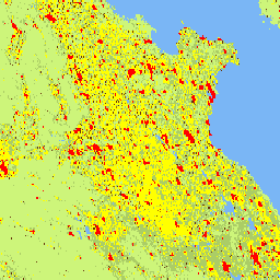
Ten rastrowy zbiór danych przedstawia globalną, wieloczasową klasyfikację obszarów wiejskich i miejskich z zastosowaniem metodologii „Stopień urbanizacji” etapu I zalecanej przez Komisję Statystyczną ONZ na podstawie globalnych danych o populacji i powierzchni zabudowanej w siatce wygenerowanych przez projekt GHSL dla okresów 1975–2030 w 5-letnich odstępach czasu. Stopień … ghsl jrc population sdg settlement -
GHSL: Global built-up surface 10m (P2023A)
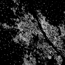
Ten rastrowy zbiór danych przedstawia rozmieszczenie powierzchni zabudowanych w 2018 roku, wyrażone w metrach kwadratowych na komórkę siatki o wymiarach 10 m × 10 m, na podstawie danych obrazów S2. Zbiory danych mierzą: a) łączną powierzchnię zabudowaną i b) powierzchnię zabudowaną przypisaną do komórek siatki o rozmiarach… built built-environment builtup copernicus ghsl jrc -
GHSL: Global built-up surface 1975-2030 (P2023A)
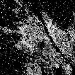
Ten zbiór danych rastrowych przedstawia rozkład powierzchni zabudowanych wyrażony w metrach kwadratowych na komórkę siatki o wymiarach 100 m x 100 m. Zbiór danych zawiera pomiary: a) całkowitej powierzchni zabudowanej i b) powierzchni zabudowanej przypisanej do komórek siatki o przeważającym zastosowaniu niemieszkalnym (NRES). Dane są interpolowane przestrzennie i czasowo lub… built built-environment builtup copernicus ghsl jrc -
GHSL: Global settlement characteristics (10 m) 2018 (P2023A)
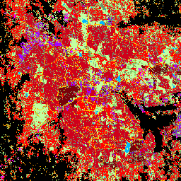
Ten przestrzenny zbiór danych rastrowych wyznacza obszary zamieszkane przez ludzi w rozdzielczości 10 m i opisuje ich wewnętrzną charakterystykę pod względem funkcjonalnych i związanych z wysokością elementów środowiska zabudowanego. Więcej informacji o produktach danych GHSL znajdziesz w raporcie GHSL Data Package 2023… building built builtup copernicus ghsl height -
World Settlement Footprint 2015
World Settlement Footprint (WSF) 2015 to maska binarna o rozdzielczości 10 m, która określa zasięg osad ludzkich na całym świecie. Została utworzona na podstawie wieloczasowych zdjęć z lat 2014–2015 wykonanych przez satelity Landsat-8 i Sentinel-1 (przetworzono odpowiednio około 217 tys. i 107 tys. scen). The temporal dynamics of human settlements … landcover landsat-derived population sentinel1-derived settlement urban
Datasets tagged settlement in Earth Engine
[null,null,[],[],[]]