-
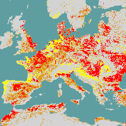
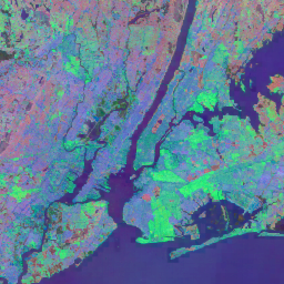
Dynamic Surface Water Extent from Sentinel-1 (DSWx-S1) V1

Ten zbiór danych zawiera dynamiczne dane o rozległości wód powierzchniowych OPERA na poziomie 3 z satelity Sentinel-1 (DSWX-S1). DSWx-S1 zapewnia niemal globalne mapowanie geograficzne zasięgu wód powierzchniowych na lądzie w rozdzielczości przestrzennej 30 metrów w systemie siatki MGRS (Military Grid Reference System) z częstotliwością ponownych wizyt między … geofizyczne nasa opera sentinel1 powierzchnia wody podziemne powierzchniowe -
ESA WorldCereal 10 m v100
Pakiet produktów WorldCereal 10 m 2021 Europejskiej Agencji Kosmicznej (ESA) obejmuje globalne mapy upraw rocznych i sezonowych oraz powiązane z nimi informacje o wiarygodności. Zostały wygenerowane w ramach projektu ESA-WorldCereal. Więcej informacji o zawartości tych produktów i metodologii użytej do … rolnictwo copernicus uprawy esa globalne pokrycie-terenu -
ESA WorldCereal Active Cropland 10 m v100
Pakiet produktów WorldCereal Active Cropland 10 m 2021 Europejskiej Agencji Kosmicznej (ESA) zawiera sezonowe znaczniki aktywnych upraw na całym świecie. Zostały wygenerowane w ramach projektu ESA-WorldCereal. Aktywne produkty dotyczące gruntów ornych wskazują, czy piksel zidentyfikowany jako uprawy tymczasowe był aktywnie… rolnictwo copernicus uprawy esa globalne pokrycie-terenu -
ESA WorldCover 10m v100

Produkt WorldCover 10 m 2020 Europejskiej Agencji Kosmicznej (ESA) to globalna mapa pokrycia terenu z 2020 r. w rozdzielczości 10 m na podstawie danych z satelitów Sentinel-1 i Sentinel-2. Produkt WorldCover zawiera 11 klas pokrycia terenu i został wygenerowany w ramach … esa landcover landuse landuse-landcover sentinel1-derived sentinel2-derived -
ESA WorldCover 10m v200
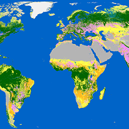
Produkt WorldCover 10 m 2021 Europejskiej Agencji Kosmicznej (ESA) to globalna mapa pokrycia terenu z 2021 r. w rozdzielczości 10 m na podstawie danych z satelitów Sentinel-1 i Sentinel-2. Produkt WorldCover zawiera 11 klas pokrycia terenu i został wygenerowany w ramach … esa landcover landuse landuse-landcover sentinel1-derived sentinel2-derived -
EUCROPMAP
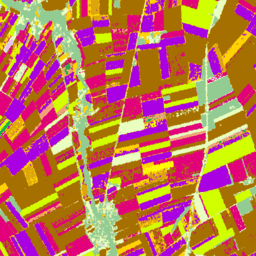
Europejskie mapy rodzajów upraw na podstawie obserwacji in situ z satelity Sentinel-1 i programu LUCAS Copernicus 2018 w 2018 r. oraz połączenia danych z satelitów Sentinel-1 i Sentinel-2 oraz danych pomocniczych z obserwacjami z programu LUCAS Copernicus 2022 w 2022 r. Ten zbiór danych, oparty na unikalnym badaniu LUCAS 2018 Copernicus, jest pierwszym … rolnictwo uprawy ue jrc lucas sentinel1 -
Globalne sezonowe dane o koherencji interferometrycznej i rozpraszaniu wstecznym z satelity Sentinel-1 V2019

Ten zbiór danych to pierwsza tego rodzaju przestrzenna reprezentacja wielosezonowych, globalnych sygnatur koherencji i rozpraszania wstecznego w paśmie C radaru z syntetyczną aperturą (SAR) w trybie interferometrycznym z wielokrotnym przelotem. Obejmuje ona lądy i pokrywy lodowe od 82 stopni szerokości geograficznej północnej do 79 stopni szerokości geograficznej południowej. Zbiór danych pochodzi z wieloczasowych … backscatter earth-big-data jpl nasa polarization radar -
Globalna sezonowa spójność interferometryczna i rozpraszanie wsteczne Sentinel-1 V2019

Ten zbiór danych to pierwsza tego rodzaju przestrzenna reprezentacja wielosezonowych, globalnych sygnatur koherencji i rozpraszania wstecznego w paśmie C radaru z syntetyczną aperturą (SAR) w trybie interferometrycznym z wielokrotnym przelotem. Obejmuje ona lądy i pokrywy lodowe od 82 stopni szerokości geograficznej północnej do 79 stopni szerokości geograficznej południowej. Zbiór danych pochodzi z wieloczasowych … earth-big-data jpl nasa polarization radar sar -
Globalne sezonowe parametry modelu rozpadu spójności interferometrycznej i rozpraszania wstecznego Sentinel-1 V2019

Ten zbiór danych to pierwsza tego rodzaju przestrzenna reprezentacja wielosezonowych, globalnych sygnatur koherencji i rozpraszania wstecznego w paśmie C radaru z syntetyczną aperturą (SAR) w trybie interferometrycznym z wielokrotnym przelotem. Obejmuje ona lądy i pokrywy lodowe od 82 stopni szerokości geograficznej północnej do 79 stopni szerokości geograficznej południowej. Zbiór danych pochodzi z wieloczasowych … earth-big-data jpl nasa polarization radar sar -
Global Seasonal Sentinel-1 Interferometric Coherence and Backscatter V2019 Incidence Layover Shadow

Ten zbiór danych to pierwsza tego rodzaju przestrzenna reprezentacja wielosezonowych, globalnych sygnatur koherencji i rozpraszania wstecznego w paśmie C radaru z syntetyczną aperturą (SAR) w trybie interferometrycznym z wielokrotnym przelotem. Obejmuje ona lądy i pokrywy lodowe od 82 stopni szerokości geograficznej północnej do 79 stopni szerokości geograficznej południowej. Zbiór danych pochodzi z wieloczasowych … earth-big-data jpl nasa polarization radar sar -
OPERA Radiometric Terrain-Corrected SAR Backscatter from Sentinel-1 Static Layers V1.0

Ten produkt zawiera statyczne warstwy geometrii radaru powiązane ze zbiorem danych OPERA Radiometric Terrain Corrected SAR Backscatter z satelity Sentinel-1. Ze względu na wąską tubę orbitalną misji S1 warstwy geometrii radarowej, takie jak kąt padania, lokalny kąt padania, liczba spojrzeń i współczynnik normalizacji obszaru RTC (ANF) … jpl nasa opera sar zdjęcia-satelitarne pochodzące-z-satelity-sentinel1 -
OPERA Radiometric Terrain-Corrected SAR Backscatter from Sentinel-1 V1.0

Ten produkt składa się z rozproszonego wstecznie sygnału radarowego znormalizowanego względem topografii. Mapuje sygnały związane z właściwościami fizycznymi obiektów rozpraszających na ziemi, takimi jak szorstkość powierzchni, wilgotność gleby lub roślinność. Produkt OPERA RTC-S1 pochodzi z danych z satelitów Copernicus Sentinel-1 w trybie Interferometric Wide (IW) … backscatter jpl nasa opera polarization radar -
Satellite Embedding V1
Zbiór danych Google Satellite Embedding to globalny zbiór wyuczonych osadzeń geoprzestrzennych gotowych do analizy. Każdy 10-metrowy piksel w tym zbiorze danych to 64-wymiarowa reprezentacja, czyli „wektor osadzania”, który koduje trajektorie czasowe warunków powierzchni w tym pikselu i wokół niego, mierzone przez różne… roczne globalne google landsat zdjęcia-satelitarne sentinel1 -
World Settlement Footprint 2015
World Settlement Footprint (WSF) 2015 to binarna maska o rozdzielczości 10 m, która przedstawia zasięg osad ludzkich na całym świecie. Została utworzona na podstawie wieloczasowych zdjęć z lat 2014–2015 z satelitów Landsat-8 i Sentinel-1 (przetworzono odpowiednio ok. 217 tys. i ok. 107 tys. scen). The temporal dynamics of human settlements … landcover landsat population sentinel1 settlement urban
Datasets tagged sentinel1-derived in Earth Engine
[null,null,[],[],[]]