-
Globalny roczny zasięg lasów namorzynowych (1984–2023)

Zbiór danych CGMD-Extent30 (Continuous Global Mangrove Dynamics-Annual Mangrove Extent at 30-m resolution) zawiera globalny roczny zasięg lasów namorzynowych w latach 1984–2023. Zbiór danych jest rozpowszechniany jako pojedynczy obiekt FeatureCollection w Earth Engine, a każdy obiekt reprezentuje zamapowany wielokąt lasu namorzynowego w określonym roku. Zbiór danych… roczne wybrzeże biomasa leśna globalne landsat użytkowanie terenu i pokrycie terenu -
Global Annual Mangrove Fractional Canopy Cover (1984-2023)

Ten zbiór danych zawiera globalne roczne dane dotyczące ułamkowego pokrycia koronami drzew mangrowych w rozdzielczości przestrzennej 30 m z lat 1984–2023. Umożliwia on przeprowadzanie analiz na dużą skalę dotyczących długoterminowej dynamiki mangrowców, w tym degradacji i odbudowy koron drzew, oceny niebieskiego węgla i monitorowania ekosystemów przybrzeżnych. Ułamkowe pokrycie koronami drzew określa proporcję każdego obrazu Landsat … roczne wybrzeże biomasa leśna globalne landsat namorzyny -
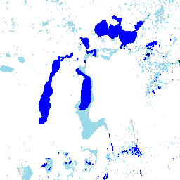
Global Mangrove Forests Distribution, v1 (2000)

Baza danych została przygotowana na podstawie danych satelitarnych Landsat z 2000 roku. Ponad 1000 scen Landsat uzyskanych z Centrum obserwacji i nauk o zasobach Ziemi (EROS) USGS zostało sklasyfikowanych przy użyciu hybrydowych technik klasyfikacji obrazów cyfrowych z nadzorem i bez nadzoru. Ta baza danych jest pierwszą i najbardziej… roczne ciesin biomasa leśna globalne landsat namorzyny -
JRC Yearly Water Classification History, v1.4
Ten zbiór danych zawiera mapy lokalizacji i rozkładu czasowego występowania wód powierzchniowych w latach 1984–2021 oraz statystyki dotyczące ich zasięgu i zmian. Więcej informacji znajdziesz w powiązanym artykule w czasopiśmie naukowym: High-resolution mapping of global surface water and its … annual geophysical google history jrc landsat-derived -
MOD44B.061 Terra Vegetation Continuous Fields Yearly Global 250m

Produkt Terra MODIS Vegetation Continuous Fields (VCF) to reprezentacja na poziomie subpikselowym szacunków pokrycia roślinnością powierzchni Ziemi na całym świecie. Został zaprojektowany tak, aby w sposób ciągły przedstawiać powierzchnię lądową Ziemi jako proporcję podstawowych cech roślinności. Zawiera gradację 3 komponentów pokrycia powierzchni: procent zagęszczenia drzew, procent … roczne geofizyczne globalne landuse-landcover modis nasa -
Open Buildings Temporal V1
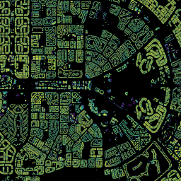
Zbiór danych Open Buildings 2.5D Temporal Dataset zawiera dane o obecności budynków, ułamkowych liczbach budynków i wysokościach budynków w efektywnej rozdzielczości przestrzennej 4 m (rastry są udostępniane w rozdzielczości 0, 5 m) w rocznej częstotliwości od 2016 r.do 2023 r. Jest on tworzony na podstawie obrazów o niskiej rozdzielczości pochodzących z otwartych źródeł, które są dostępne w … afryka roczne azja zabudowa wysokość budynki-otwarte -
Satellite Embedding V1
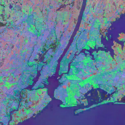
Zbiór danych Google Satellite Embedding to gotowa do analizy globalna kolekcja wyuczonych osadzeń geoprzestrzennych. Każdy 10-metrowy piksel w tym zbiorze danych to 64-wymiarowa reprezentacja, czyli „wektor osadzania”, który koduje trajektorie czasowe warunków powierzchni w tym pikselu i wokół niego, mierzone przez różne obserwacje Ziemi… roczne globalne google landsat zdjęcia-satelitarne sentinel1 -
VIIRS Nighttime Day/Night Annual Band Composites V2.1

Roczny globalny zbiór danych o oświetleniu nocnym VIIRS to szereg czasowy utworzony na podstawie miesięcznych siatek średniego promieniowania bez chmur obejmujących okres od 2013 r. do 2021 r. Dane za 2022 r. są dostępne w zbiorze danych NOAA/VIIRS/DNB/ANNUAL_V22. Wstępny etap filtrowania usunął piksele oświetlone przez słońce, księżyc i chmury, co doprowadziło do powstania przybliżonych kompozytów, które… annual dnb eog lights nighttime noaa -
VIIRS Nighttime Day/Night Annual Band Composites V2.2

Roczny globalny zbiór danych o światłach nocnych VIIRS to szereg czasowy utworzony na podstawie miesięcznych siatek średniego promieniowania bez chmur za 2022 r. Dane z wcześniejszych lat są dostępne w zbiorze danych NOAA/VIIRS/DNB/ANNUAL_V21. Wstępny etap filtrowania usunął piksele oświetlone przez słońce, księżyc i chmury, co doprowadziło do powstania przybliżonych kompozytów zawierających... annual dnb eog lights nighttime noaa
Datasets tagged annual in Earth Engine
[null,null,[],[],["The datasets provide annual global information on various Earth features. The Open Buildings dataset offers building presence, counts, and heights from 2016-2023. JRC data maps surface water distribution and changes from 1984-2021. Another dataset, based on data from 2000, details mangrove forest distribution. MODIS data provides continuous vegetation cover estimates, including tree cover percentages. Lastly, VIIRS data sets map annual nighttime light composites from 2013-2022, based on cloud-free average radiance grids.\n"]]