Dane te zostały wygenerowane na podstawie 4 716 475 scen z satelitów Landsat 5, 7 i 8, które zostały zarejestrowane między 16 marca 1984 r. a 31 grudnia 2021 r.
Każdy piksel został indywidualnie sklasyfikowany jako woda lub nie-woda za pomocą systemu eksperckiego, a wyniki zostały zestawione w miesięczną historię dla całego okresu i dwóch epok (1984–1999, 2000–2021) na potrzeby wykrywania zmian.
Ta kolekcja klasyfikacji sezonowości rocznej zawiera klasyfikację sezonowości wody w poszczególnych latach na podstawie wartości występowania wykrytych w ciągu roku.
Pasma
Rozmiar piksela 30 metrów
Pasma
Nazwa
Rozmiar piksela
Opis
waterClass
metry
Klasyfikacja sezonowości wody w ciągu roku.
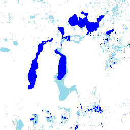
Tabela klas waterClass
Wartość
Kolor
Opis
0
#cccccc
Brak danych
1
#ffffff
Nie woda
2
#99d9ea
Woda sezonowa
3
#0000ff
Stałe zbiorniki wodne
Właściwości obrazu
Właściwości obrazu
Nazwa
Typ
Opis
rok
LICZBA ZMIENNOPRZECINKOWA O PODWÓJNEJ PRECYZJI
Rok
Warunki korzystania z usługi
Wszystkie dane są tworzone w ramach programu Copernicus i udostępniane bezpłatnie, bez ograniczeń dotyczących ich wykorzystania. Pełne informacje o licencji znajdziesz w rozporządzeniu Copernicus.
Publikacje, modele i usługi danych, które korzystają z tych zbiorów danych, muszą zawierać odpowiednie podziękowania, w tym cytowanie zbiorów danych i artykułu w czasopiśmie, jak w tym przykładzie:
Jeśli używasz danych jako warstwy na opublikowanej mapie, podaj ten tekst z atrybucją: „Źródło: EC JRC/Google”.
Cytaty
Cytowania:
Jean-Francois Pekel, Andrew Cottam, Noel Gorelick, Alan S. Belward, High-resolution mapping of global surface water and its long-term changes (Mapowanie w wysokiej rozdzielczości globalnych wód powierzchniowych i ich długoterminowych zmian).
Nature 540, 418-422 (2016). (doi:10.1038/nature20584)
Ten zbiór danych zawiera mapy lokalizacji i rozmieszczenia w czasie wód powierzchniowych w latach 1984–2021 oraz statystyki dotyczące zasięgu i zmian tych wód. Więcej informacji znajdziesz w powiązanym artykule w czasopiśmie: High-resolution mapping of global surface water and its long-term changes (Nature, 2016) i …
[null,null,[],[[["\u003cp\u003eThe JRC Yearly Water Classification History dataset provides yearly maps of surface water from 1984 to 2021, including the seasonality of water.\u003c/p\u003e\n"],["\u003cp\u003eIt's based on Landsat 5, 7, and 8 imagery and classifies each pixel as water or non-water, offering insights into the extent and change of surface water over time.\u003c/p\u003e\n"],["\u003cp\u003eThe dataset has a 30-meter resolution and includes a 'waterClass' band to indicate permanent, seasonal, or no water.\u003c/p\u003e\n"],["\u003cp\u003eIt's freely available for use with proper attribution to EC JRC/Google and citation of the associated journal article.\u003c/p\u003e\n"],["\u003cp\u003eUsers can explore and analyze the dataset using Google Earth Engine.\u003c/p\u003e\n"]]],[],null,["# JRC Yearly Water Classification History, v1.4\n\nDataset Availability\n: 1984-03-16T00:00:00Z--2022-01-01T00:00:00Z\n\nDataset Provider\n:\n\n\n [EC JRC / Google](https://global-surface-water.appspot.com)\n\nCadence\n: 1 Year\n\nTags\n:\n[annual](/earth-engine/datasets/tags/annual) [geophysical](/earth-engine/datasets/tags/geophysical) [google](/earth-engine/datasets/tags/google) [history](/earth-engine/datasets/tags/history) [jrc](/earth-engine/datasets/tags/jrc) [landsat-derived](/earth-engine/datasets/tags/landsat-derived) [surface](/earth-engine/datasets/tags/surface) [surface-ground-water](/earth-engine/datasets/tags/surface-ground-water) [water](/earth-engine/datasets/tags/water) [yearly](/earth-engine/datasets/tags/yearly) \n\n#### Description\n\nThis dataset contains maps of the location and temporal\ndistribution of surface water from 1984 to 2021 and provides\nstatistics on the extent and change of those water surfaces.\nFor more information see the associated journal article: [High-resolution\nmapping of global surface water and its long-term changes](https://www.nature.com/nature/journal/v540/n7633/full/nature20584.html)\n(Nature, 2016) and the online\n[Data Users Guide](https://storage.googleapis.com/global-surface-water/downloads_ancillary/DataUsersGuidev2021.pdf).\n\nThese data were generated using 4,716,475 scenes from Landsat\n5, 7, and 8 acquired between 16 March 1984 and 31 December 2021.\nEach pixel was individually classified into water / non-water\nusing an expert system and the results were collated into a monthly\nhistory for the entire time period and two epochs (1984-1999,\n2000-2021) for change detection.\n\nThis Yearly Seasonality Classification collection contains a year-by-year\nclassification of the seasonality of water based on the occurrence values\ndetected throughout the year.\n\n### Bands\n\n\n**Pixel Size**\n\n30 meters\n\n**Bands**\n\n| Name | Pixel Size | Description |\n|--------------|------------|-----------------------------------------------------------------|\n| `waterClass` | meters | Classification of the seasonality of water throughout the year. |\n\n**waterClass Class Table**\n\n| Value | Color | Description |\n|-------|---------|-----------------|\n| 0 | #cccccc | No data |\n| 1 | #ffffff | Not water |\n| 2 | #99d9ea | Seasonal water |\n| 3 | #0000ff | Permanent water |\n\n### Image Properties\n\n**Image Properties**\n\n| Name | Type | Description |\n|------|--------|-------------|\n| year | DOUBLE | Year |\n\n### Terms of Use\n\n**Terms of Use**\n\nAll data here is produced under the Copernicus Programme and is provided\nfree of charge, without restriction of use. For the full license\ninformation see the Copernicus Regulation.\n\nPublications, models, and data products that make use of these datasets\nmust include proper acknowledgement, including citing datasets and the\njournal article as in the following citation.\n\nIf you are using the data as a layer in a published map, please include the\nfollowing attribution text: 'Source: EC JRC/Google'\n\n### Citations\n\nCitations:\n\n- Jean-Francois Pekel, Andrew Cottam, Noel Gorelick, Alan S. Belward,\n High-resolution mapping of global surface water and its long-term changes.\n Nature 540, 418-422 (2016). ([doi:10.1038/nature20584](https://doi.org/10.1038/nature20584))\n\n### Explore with Earth Engine\n\n| **Important:** Earth Engine is a platform for petabyte-scale scientific analysis and visualization of geospatial datasets, both for public benefit and for business and government users. Earth Engine is free to use for research, education, and nonprofit use. To get started, please [register for Earth Engine access.](https://console.cloud.google.com/earth-engine)\n\n### Code Editor (JavaScript)\n\n```javascript\nvar dataset = ee.ImageCollection('JRC/GSW1_4/YearlyHistory');\n\nvar visualization = {\n bands: ['waterClass'],\n min: 0.0,\n max: 3.0,\n palette: ['cccccc', 'ffffff', '99d9ea', '0000ff']\n};\n\nMap.setCenter(59.414, 45.182, 7);\n\nMap.addLayer(dataset, visualization, 'Water Class');\n```\n[Open in Code Editor](https://code.earthengine.google.com/?scriptPath=Examples:Datasets/JRC/JRC_GSW1_4_YearlyHistory) \n[JRC Yearly Water Classification History, v1.4](/earth-engine/datasets/catalog/JRC_GSW1_4_YearlyHistory) \nThis dataset contains maps of the location and temporal distribution of surface water from 1984 to 2021 and provides statistics on the extent and change of those water surfaces. For more information see the associated journal article: High-resolution mapping of global surface water and its long-term changes (Nature, 2016) and ... \nJRC/GSW1_4/YearlyHistory, annual,geophysical,google,history,jrc,landsat-derived,surface,surface-ground-water,water,yearly \n1984-03-16T00:00:00Z/2022-01-01T00:00:00Z \n-59 -180 78 180 \nGoogle Earth Engine \nhttps://developers.google.com/earth-engine/datasets\n\n- [](https://doi.org/https://global-surface-water.appspot.com)\n- [](https://doi.org/https://developers.google.com/earth-engine/datasets/catalog/JRC_GSW1_4_YearlyHistory)"]]