- Dostępność zbioru danych
- 2015-01-01T00:00:00Z–2016-01-01T00:00:00Z
- Dostawca zbioru danych
- Deutsches Zentrum für Luft- und Raumfahrt (DLR)
- Tagi
Opis
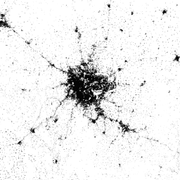
World Settlement Footprint (WSF) 2015 to binarna maska o rozdzielczości 10 m, która przedstawia zasięg osad ludzkich na całym świecie. Została ona utworzona na podstawie wieloczasowych zdjęć z lat 2014–2015 z satelitów Landsat-8 i Sentinel-1 (przetworzono odpowiednio około 217 000 i 107 000 scen).
Dynamika czasowa osad ludzkich różni się w sensowny sposób od dynamiki wszystkich innych klas informacji niezwiązanych z osadami. Dlatego na podstawie wszystkich obrazów wieloczasowych dostępnych w wybranym przedziale czasu w interesującym nas regionie wyodrębniane są kluczowe statystyki czasowe (np. średnia czasowa, minimum, maksimum itp.) dotyczące:
- pierwotną wartość rozproszenia wstecznego w przypadku danych radarowych;
- różne indeksy spektralne (np. indeks wegetacji, indeks zabudowy itp.) uzyskane po zamaskowaniu chmur w przypadku zdjęć optycznych;
Następnie do cech czasowych optycznych i radarowych stosowane są oddzielnie różne schematy klasyfikacji oparte na maszynach wektorów nośnych (SVM), a na koniec oba wyniki są odpowiednio łączone.
Aby ilościowo ocenić wysoką dokładność i niezawodność warstwy, przeprowadziliśmy we współpracy z Google obszerne testy weryfikacyjne na podstawie ogromnej liczby danych podstawowych (czyli 900 tys.) oznaczonych przez osoby interpretujące zdjęcia. Zdefiniowano statystycznie solidny i przejrzysty protokół zgodny z najnowocześniejszymi praktykami zalecanymi obecnie w literaturze.
Wszystkie szczegóły techniczne znajdziesz w publikacji.
Pasma
Pasma
Rozmiar piksela: 10 m (wszystkie pasma)
| Nazwa | Minimum | Maks. | Rozmiar piksela | Opis |
|---|---|---|---|---|
settlement |
255 | 255 | 10 metrów | obszar osadnictwa ludzkiego, |
Warunki korzystania z usługi
Warunki korzystania z usługi
Cytaty
Marconcini, M., Metz-Marconcini, A., Üreyen, S., Palacios-Lopez, D., Hanke, W., Bachofer, F., Zeidler, J., Esch, T., Gorelick, N., Kakarla, A., Paganini, M., Strano, E. (2020). Określenie miejsc zamieszkania ludzi na podstawie danych World Settlement Footprint 2015. Scientific Data, 7(1), 1-14. doi:10.1038/s41597-020-00580-5
DOI
Odkrywaj za pomocą Earth Engine
Edytor kodu (JavaScript)
var dataset = ee.Image('DLR/WSF/WSF2015/v1');

var opacity = 0.75;
var blackBackground = ee.Image(0);
Map.addLayer(blackBackground, null, 'Black background', true, opacity);

var visualization = {
  min: 0,
  max: 255,
};
Map.addLayer(dataset, visualization, 'Human settlement areas');

Map.setCenter(90.45, 23.7, 7);