- Dostępność zbioru danych
- 2020-01-01T00:00:00Z–2021-12-31T23:59:59Z
- Dostawca zbioru danych
- ESA WorldCereal Consortium
- Tagi
Opis
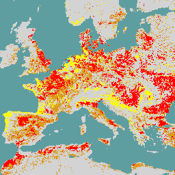
Pakiet produktów WorldCereal 10 m 2021 Europejskiej Agencji Kosmicznej (ESA) obejmuje mapy upraw w skali globalnej, które są aktualizowane co roku i sezonowo, oraz powiązane z nimi informacje o wiarygodności. Zostały one wygenerowane w ramach projektu ESA-WorldCereal. Więcej informacji o zawartości tych produktów i metodologii użytej do ich wygenerowania znajdziesz w [1].
Ta kolekcja zawiera do 106 obrazów stref agroekologicznych (AEZ) dla każdego produktu. Wszystkie obrazy zostały przetworzone z uwzględnieniem sezonowości regionalnej i należy je traktować jako niezależne produkty. Te sezony są opisane na liście poniżej i zostały opracowane w [2] w ramach projektu. Pamiętaj, że zboża w rozumieniu WorldCereal obejmują pszenicę, jęczmień i żyto, które należą do plemienia Triticeae.
Opis sezonów WorldCereal:
- tc-annual: cykl roczny zdefiniowany w strefie AEZ do końca ostatniego rozpatrywanego sezonu wegetacyjnego
- tc-wintercereals: główny sezon uprawy zbóż zdefiniowany w strefie agroekologicznej;
- tc-springcereals: opcjonalny sezon zbóż jarych, zdefiniowany tylko w niektórych strefach AEZ
- tc-maize-main: główny sezon uprawy kukurydzy zdefiniowany w strefie klimatyczno-rolniczej;
- tc-maize-second: opcjonalny drugi sezon uprawy kukurydzy, zdefiniowany tylko w niektórych strefach klimatyczno-ekologicznych;
Dostępne produkty w tej kolekcji to:
- temporarycrops
- Maize
- wintercereals
- springcereals
- nawadnianie,
Każdy produkt (obraz) ma klasyfikację binarną (0 lub 100) i przedział ufności (0–100). Pamiętaj, że strefy AEZ, w których nie ma dostępnych produktów do nawadniania, nie zostały przetworzone z powodu braku danych termicznych z satelity Landsat.
Kolekcję należy filtrować przy użyciu co najmniej 1 z tych właściwości obrazu:
- aez_id, który zawiera identyfikator AEZ, do którego należy obraz;
- produkt, opisujący nazwę produktu WorldCereal na obrazie;
- season, opisujący sezon, w którym obraz jest ważny.
Źródła:
Zbiory danych WorldCereal:
- Wersja 100 na rok 2021
Pasma
Rozmiar piksela
10 metrów
Pasma
| Nazwa | Minimum | Maks. | Rozmiar piksela | Opis |
|---|---|---|---|---|
classification |
0 | 100 | metry | Klasyfikacja: 0 lub 100 |
confidence |
0 | 100 | metry | Poziom ufności (od 0 do 100) |
Właściwości obrazu
Właściwości obrazu
| Nazwa | Typ | Opis |
|---|---|---|
| aez_id | PRZ | Identyfikator strefy agroekologicznej, do której należy produkt. |
| produkt | CIĄG ZNAKÓW | Nazwa produktu WorldCereal. |
| season | CIĄG ZNAKÓW | Sezon, w którym produkt jest ważny. |
Warunki korzystania z usługi
Warunki korzystania z usługi
Cytaty
Van Tricht, K., Degerickx, J., Gilliams, S., Zanaga, D., Battude, M., Grosu, A., Brombacher, J., Lesiv, M., Bayas, J. C. L., Karanam, S., Fritz, S., Becker-Reshef, I., Franch, B., Mollà-Bononad, B., Boogaard, H., Pratihast, A. K. i Szantoi, Z.: WorldCereal: dynamiczny system open source do tworzenia map upraw i nawadniania na skalę globalną, sezonową i powtarzalną, Earth Syst. Sci. Data Discuss. [preprint], doi:10.5194/essd-2023-184, w trakcie recenzji, 2023.
DOI
Odkrywanie za pomocą Earth Engine
Edytor kodu (JavaScript)
var dataset = ee.ImageCollection('ESA/WorldCereal/2021/MODELS/v100')

// Set satellite background
Map.setOptions('SATELLITE');

// Typically we'd want to mask the "other" class (value 0)
// in the images
function mask_other(img) {
  return img.updateMask(img.neq(0))
}

// Apply the mask_other function to the collection
dataset = dataset.map(mask_other);

/*--------------------------------------------------
Basic example for a global mosaic of temporary crops
--------------------------------------------------*/

// Get a global mosaic for all agro-ecological zone (AEZ) of temporary crops
var temporarycrops = dataset.filter('product == "temporarycrops"').mosaic();

// Visualization specifics
var visualization_class = {
  bands: ["classification"],
  max: 100,
  palette: ["ff0000"]
};

var visualization_conf = {
  bands: ['confidence'],
  min: [0],
  max: [100],
  palette: ['be0000','fff816','069711'],
};

// Show global classification mosaic
Map.centerObject(temporarycrops);
Map.addLayer(temporarycrops, visualization_class, 'Temporary crops');

// By default don't show confidence layer
Map.addLayer(
    temporarycrops, visualization_conf, 'Temporary crops confidence', false);

/*--------------------------------------------------
Advanced example for tc-maize-main season products
in a specific AEZ
--------------------------------------------------*/

// Filter on AEZ and season
var tc_maize_main_46172 = dataset.filter(
  ee.Filter.eq('season', 'tc-maize-main')
  ).filter(ee.Filter.eq('aez_id', 46172));

// Get the different products
var maize = tc_maize_main_46172.filter('product == "maize"');
var irrigation = tc_maize_main_46172.filter('product == "irrigation"');

// Visualization specifics
var visualization_maize = {
  bands: ["classification"],
  max: 100,
  palette: ["#ebc334"]
};

var visualization_irrigation = {
  bands: ["classification"],
  max: 100,
  palette: ["#2d79eb"]
};

// Show maize and irrigation classification
Map.addLayer(maize, visualization_maize, 'Maize');
Map.addLayer(irrigation, visualization_irrigation, 'Active irrigation');

// Uncomment the line below to zoom to a region
// where maize, other crops and active irrigation are visible
// Map.setCenter(-0.9911, 43.5017, 12)