- Dostępność zbioru danych
- 2018-01-01T00:00:00Z–2022-01-01T00:00:00Z
- Dostawca zbioru danych
- Joint Research Center (JRC)
- Cykl
- 1 rok
- Tagi
Opis
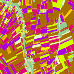
Europejskie mapy typów upraw na podstawie danych Sentinel-1 i obserwacji in situ LUCAS Copernicus 2018 z 2018 r. oraz połączenia danych Sentinel-1, Sentinel-2 i danych pomocniczych z obserwacjami LUCAS Copernicus 2022 z 2022 r.
Ten zbiór danych, oparty na unikalnym badaniu LUCAS 2018 Copernicus in-situ, jest pierwszą mapą typów upraw w skali UE o rozdzielczości 10 m, która została opracowana wyłącznie na podstawie obserwacji radarowych z syntetyczną aperturą S1A i S1B. Zbiór danych z 2022 roku kontynuuje te działania, wykorzystując podejście wieloźródłowe, które łączy zdjęcia z satelitów Sentinel-1 i Sentinel-2 z danymi o temperaturze i wysokości, a także obserwacje LUCAS z 2022 roku.
Pasma
Rozmiar piksela
10 m
Pasma
| Nazwa | Rozmiar piksela | Opis |
|---|---|---|
classification |
metry | Klasyfikacja pokrycia terenu pod kątem głównych upraw. |
Tabela klasyfikacji
| Wartość | Kolor | Opis |
|---|---|---|
| 100 | #ff130f | Sztuczne |
| 211 | #a57000 | pszenica zwyczajna, |
| 212 | #896054 | Pszenica durum |
| 213 | #e2007c | Barley |
| 214 | #aa007c | Rye |
| 215 | #a05989 | Owsiane |
| 216 | #ffd300 | Maize |
| 217 | #00a8e2 | Rice |
| 218 | #d69ebc | Triticale |
| 219 | #d69ebc | Inne zboża |
| 221 | #dda50a | Ziemniaki |
| 222 | #a800e2 | Burak cukrowy |
| 223 | #00af49 | Inne warzywa korzeniowe |
| 230 | #00af49 | Inne niepermanentne uprawy przemysłowe |
| 231 | #ffff00 | Słonecznik |
| 232 | #d1ff00 | Rzepak i rzepik |
| 233 | #267000 | Soya |
| 240 | #f2a377 | Suche rośliny strączkowe |
| 250 | #e8bfff | Rośliny pastewne (zboża i rośliny strączkowe) |
| 290 | #696969 | nieużytki rolne, |
| 300 | #93cc93 | Lasy i zarośla (w tym uprawy trwałe) |
| 500 | #e8ffbf | Sawanny |
| 600 | #a89e7f | Nieporośnięty teren/porosty |
| 700 | #0793de | Woda |
| 800 | #7cafaf | Moczary |
Właściwości obrazu
Właściwości obrazu
| Nazwa | Typ | Opis |
|---|---|---|
| classification_class_names | CIĄG ZNAKÓW_LISTA | Tablica nazw klasyfikacji gruntów ornych. |
| classification_class_palette | CIĄG ZNAKÓW_LISTA | Tablica ciągów znaków z szesnastkowymi kodami kolorów używanych w palecie klasyfikacji. |
| classification_class_values | INT_LIST | Wartość klasyfikacji gruntów ornych. |
Warunki korzystania z usługi
Warunki usługi
Cytaty
d'Andrimont, R., Verhegghen, A., Lemoine, G., Kempeneers, P., Meroni, M., & Van der Velde, M. (2021). Od działki do kontynentu – pierwsza europejska mapa typów upraw na podstawie obserwacji satelitarnych Sentinel-1 i obserwacji in situ LUCAS Copernicus. Remote sensing of environment, 266, 112708.
d'Andrimont, R., Verhegghen, A., Lemoine, G., Kempeneers, P., Meroni, M., & Van der Velde, M. (2021). Od działki do kontynentu – pierwsza europejska mapa typów upraw na podstawie obserwacji satelitarnych Sentinel-1 i obserwacji in situ LUCAS Copernicus. Remote sensing of environment, 266, 112708. doi:10.1016/j.rse.2021.112708.
Ghassemi, B., Izquierdo-Verdiguier, E., Verhegghen, A., Yordanov, M., Lemoine, G., Moreno Martínez, Á., De Marchi, D., van der Velde, M., Vuolo, F. i d’Andrimont, R., 2024 r. Mapa upraw w Unii Europejskiej w 2022 r.: obserwacje Ziemi z dokładnością do 10 metrów w celu stworzenia mapy upraw w Europie. Scientific Data, 11(1), s.1048. 10.1038/s41597-024-03884-y
DOI
Odkrywanie za pomocą Earth Engine
Edytor kodu (JavaScript)
var image = ee.ImageCollection('JRC/D5/EUCROPMAP/V1').filterDate(
    '2018-01-01', '2019-01-01').first();
Map.addLayer(image, {}, 'EUCROPMAP 2018');
Map.setCenter(10, 48, 4);