- Dostępność zbioru danych
- 1975-01-01T00:00:00Z–2030-12-31T00:00:00Z
- Dostawca zbioru danych
- EC JRC
- Tagi
Opis
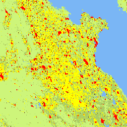
Ten rastrowy zbiór danych przedstawia globalną, wieloczasową klasyfikację obszarów wiejskich i miejskich, która wykorzystuje metodologię „Stopień urbanizacji” I zalecaną przez Komisję Statystyczną ONZ. Zbiór ten opiera się na globalnych danych o populacji w siatce i danych o powierzchni zabudowanej wygenerowanych przez projekt GHSL dla okresów 1975–2030 w 5-letnich odstępach. Warstwy stopnia urbanizacji zostały wygenerowane na podstawie informacji o powierzchni zabudowanej uzyskanych z danych Landsat i Sentinel-2 GHS-BUILT-S R2023 oraz danych o populacji w siatce pochodzących z CIESIN GPW v4.11 GHS-POP R2023. Ten produkt to aktualizacja danych opublikowanych w 2023 r. na podstawie aktualizacji GHS-BUILT-S i GHS-POP. Model rozliczeń jest podawany na poziomie szczegółowym (poziom drugi – L2). Klasyfikację pierwszego poziomu można uzyskać przez agregację klasyfikacji L2.
Pełne informacje o głównych produktach GHSL znajdziesz w raporcie GHSL Data Package 2023.
Projekt Global Human Settlement Layer (GHSL) jest wspierany przez Komisję Europejską, Wspólne Centrum Badawcze oraz Dyrekcję Generalną ds. Polityki Regionalnej i Miejskiej.
Pasma
Rozmiar piksela
1000 metrów
Pasma
| Nazwa | Rozmiar piksela | Opis |
|---|---|---|
smod_code |
metry | Stopień urbanizacji |
Tabela klas smod_code
| Wartość | Kolor | Opis |
|---|---|---|
| -200 | #000000 | Brak danych |
| 10 | #7ab6f5 | Woda |
| 11 | #cdf57a | Bardzo niska gęstość zaludnienia na obszarach wiejskich |
| 12 | #abcd66 | Obszar wiejski o niskiej gęstości zaludnienia |
| 13 | #375623 | Klaster wiejski |
| 21 | #ffff00 | Podmiejskie lub okołomiejskie |
| 22 | #a87000 | Półgęste skupisko miejskie |
| 23 | #732600 | Gęsty klaster miejski |
| 30 | #ff0000 | Centrum miejskie |
Warunki korzystania z usługi
Warunki korzystania z usługi
GHSL został opracowany przez Wspólne Centrum Badawcze Komisji Europejskiej jako otwarte i bezpłatne dane. Ponowne wykorzystanie jest dozwolone pod warunkiem podania źródła. Więcej informacji znajdziesz w warunkach korzystania (European Commission Reuse and Copyright Notice).
Cytaty
Zbiór danych : Schiavina, Marcello; Melchiorri, Michele; Pesaresi, Martino (2023): GHS-SMOD R2023A – GHS settlement layers, application of the Degree of Urbanisation methodology (stage I) to GHS-POP R2023A and GHS-BUILT-S R2023A, multitemporal (1975–2030). Komisja Europejska, Wspólne Centrum Badawcze (JRC) PID: http://data.europa.eu/89h/a0df7a6f-49de-46ea-9bde-563437a6e2ba doi:10.2905/A0DF7A6F-49DE-46EA-9BDE-563437A6E2BA
Metodologia : Pesaresi, Martino, Marcello Schiavina, Panagiotis Politis, Sergio Freire, Katarzyna Krasnodebska, Johannes H. Uhl, Alessandra Carioli i in. (2024). Postępy w zakresie globalnej warstwy osadnictwa ludzkiego dzięki wspólnej ocenie danych z obserwacji Ziemi i badań ankietowych populacji. International Journal of Digital Earth 17(1). doi:10.1080/17538947.2024.2390454.
DOI
Odkrywanie za pomocą Earth Engine
Edytor kodu (JavaScript)
var image = ee.Image("JRC/GHSL/P2023A/GHS_SMOD_V2-0/2030");
var smod = image.select('smod_code');
Map.setCenter(84, 25, 5);
Map.addLayer(image, {}, 'Degree of Urbanization');