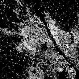
Ten rastrowy zbiór danych przedstawia rozkład powierzchni zabudowanych wyrażony w metrach kwadratowych na komórkę siatki o wymiarach 100 m x 100 m.
Zbiór danych zawiera pomiary: a) całkowitej powierzchni zabudowanej i b) powierzchni zabudowanej przypisanej do komórek siatki o przeważającym zastosowaniu niemieszkalnym (NRES). Dane są interpolowane lub ekstrapolowane przestrzennie i czasowo w 5-letnich odstępach od 1975 r. do 2030 r.
Projekt Global Human Settlement Layer (GHSL) jest wspierany przez Komisję Europejską, Wspólne Centrum Badawcze oraz Dyrekcję Generalną ds. Polityki Regionalnej i Miejskiej.
Pasma
Rozmiar piksela 100 metrów
Pasma
Nazwa
Jednostki
Rozmiar piksela
Opis
built_surface
m^2
metry
Powierzchnia zabudowana w komórce siatki
built_surface_nres
m^2
metry
Powierzchnia zabudowana niezwiązana z mieszkalnictwem w poszczególnych komórkach siatki
Warunki korzystania z usługi
GHSL został opracowany przez Wspólne Centrum Badawcze Komisji Europejskiej jako otwarte i bezpłatne dane. Ponowne wykorzystanie jest dozwolone pod warunkiem podania źródła. Więcej informacji znajdziesz w warunkach korzystania (European
Commission Reuse and Copyright Notice).
Metodologia : Pesaresi, Martino, Marcello Schiavina, Panagiotis Politis, Sergio Freire, Katarzyna Krasnodebska, Johannes H. Uhl, Alessandra Carioli i in. (2024). Postępy w zakresie globalnej warstwy osadnictwa ludzkiego dzięki wspólnej ocenie danych z obserwacji Ziemi i badań ankietowych populacji. International Journal of Digital Earth 17(1).
doi:10.1080/17538947.2024.2390454.
Ten zbiór danych rastrowych przedstawia rozmieszczenie powierzchni zabudowanych wyrażone w metrach kwadratowych na komórkę siatki o wymiarach 100 m x 100 m. Zbiór danych zawiera pomiary: a) całkowitej powierzchni zabudowanej i b) powierzchni zabudowanej przypisanej do komórek siatki o przeważającym zastosowaniu niemieszkalnym (NRES). Dane są interpolowane lub ekstrapolowane przestrzennie i czasowo w okresie od 1975 r. do 2030 r.
[null,null,[],[[["\u003cp\u003eThe Global Human Settlement Layer (GHSL) dataset provides data on built-up surfaces globally, including residential and non-residential areas, at a 100-meter resolution.\u003c/p\u003e\n"],["\u003cp\u003eIt offers temporal coverage from 1975 to 2030 in 5-year intervals, with data spatially-temporally interpolated or extrapolated.\u003c/p\u003e\n"],["\u003cp\u003eDeveloped by the European Commission Joint Research Centre, the dataset is freely available for reuse with proper attribution.\u003c/p\u003e\n"],["\u003cp\u003eThe GHSL dataset is derived from Sentinel-2 and Landsat imagery and provides insights into global urbanization trends.\u003c/p\u003e\n"],["\u003cp\u003eBuilt-up surface is measured in square meters per grid cell and includes both total and non-residential built-up areas.\u003c/p\u003e\n"]]],["The dataset, provided by EC JRC, spans 1975-2030, presenting built-up surface distribution in square meters per 100m grid cell. It quantifies total built-up area and non-residential (NRES) built-up area, extrapolated every five years. The data, available through Earth Engine, includes `built_surface` and `built_surface_nres` bands at 100-meter resolution. It is free to use, and reuse is authorized, provided the source is acknowledged. This information can be explored in the Code Editor.\n"],null,["# GHSL: Global built-up surface 1975-2030 (P2023A)\n\nDataset Availability\n: 1975-01-01T00:00:00Z--2030-12-31T00:00:00Z\n\nDataset Provider\n:\n\n\n [EC JRC](https://ghsl.jrc.ec.europa.eu/ghs_buS2023.php)\n\nTags\n:\n[built](/earth-engine/datasets/tags/built) [built-environment](/earth-engine/datasets/tags/built-environment) [builtup](/earth-engine/datasets/tags/builtup) [copernicus](/earth-engine/datasets/tags/copernicus) [ghsl](/earth-engine/datasets/tags/ghsl) [jrc](/earth-engine/datasets/tags/jrc) [landcover](/earth-engine/datasets/tags/landcover) [landsat-derived](/earth-engine/datasets/tags/landsat-derived) [population](/earth-engine/datasets/tags/population) [sdg](/earth-engine/datasets/tags/sdg) [sentinel2-derived](/earth-engine/datasets/tags/sentinel2-derived) [settlement](/earth-engine/datasets/tags/settlement) [urban](/earth-engine/datasets/tags/urban) \n\n#### Description\n\nThis raster dataset depicts the distribution of built-up surfaces,\nexpressed in square metres per 100 m grid cell.\nThe dataset measures:\na) the total built-up surface, and b) the built-up surface allocated to grid\ncells of predominant non-residential (NRES) use. Data are\nspatially-temporally interpolated or extrapolated from 1975 to 2030 in 5\nyear intervals.\n\nThe complete information about the GHSL main products can be\nfound in the [GHSL Data Package 2023 report](https://ghsl.jrc.ec.europa.eu/documents/GHSL_Data_Package_2023.pdf?t=1683540422)\n\nThe Global Human Settlement Layer (GHSL) project is supported by the\nEuropean Commission, Joint Research Centre, and Directorate-General for\nRegional and Urban Policy.\n\n### Bands\n\n\n**Pixel Size**\n\n100 meters\n\n**Bands**\n\n| Name | Units | Pixel Size | Description |\n|----------------------|-------|------------|------------------------------------------------|\n| `built_surface` | m\\^2 | meters | Built-up surface per grid cell |\n| `built_surface_nres` | m\\^2 | meters | Non-residential built-up surface per grid cell |\n\n### Terms of Use\n\n**Terms of Use**\n\nThe GHSL has been produced by the European Commission Joint Research Centre\nas open and free data. Reuse is authorised, provided the source is\nacknowledged. For more information, please read the use conditions ([European\nCommission Reuse and Copyright Notice](https://ec.europa.eu/info/legal-notice_en)).\n\n### Citations\n\nCitations:\n\n- Dataset : Pesaresi, Martino; Politis, Panagiotis (2023): GHS-BUILT-S\n R2023A - GHS built-up surface grid, derived from Sentinel2 composite and\n Landsat, multitemporal (1975-2030). European Commission, Joint Research\n Centre (JRC).\n [PID: http://data.europa.eu/89h/9f06f36f-4b11-47ec-abb0-4f8b7b1d72ea](http://data.europa.eu/89h/9f06f36f-4b11-47ec-abb0-4f8b7b1d72ea)\n [doi:10.2905/9F06F36F-4B11-47EC-ABB0-4F8B7B1D72EA](https://doi.org/10.2905/9F06F36F-4B11-47EC-ABB0-4F8B7B1D72EA)\n- Methodology : Pesaresi, Martino, Marcello Schiavina, Panagiotis Politis,\n Sergio Freire, Katarzyna Krasnodebska,\n Johannes H. Uhl, Alessandra Carioli, et al. (2024). Advances on the\n Global Human Settlement Layer by Joint Assessment of Earth Observation\n and Population Survey Data. International Journal of Digital Earth 17(1).\n [doi:10.1080/17538947.2024.2390454](https://doi.org/10.1080/17538947.2024.2390454).\n\n### DOIs\n\n- \u003chttps://doi.org/10.1080/17538947.2024.2390454\u003e\n- \u003chttps://doi.org/10.2905/9F06F36F-4B11-47EC-ABB0-4F8B7B1D72EA\u003e\n\n### Explore with Earth Engine\n\n| **Important:** Earth Engine is a platform for petabyte-scale scientific analysis and visualization of geospatial datasets, both for public benefit and for business and government users. Earth Engine is free to use for research, education, and nonprofit use. To get started, please [register for Earth Engine access.](https://console.cloud.google.com/earth-engine)\n\n### Code Editor (JavaScript)\n\n```javascript\nvar image_1975 = ee.Image('JRC/GHSL/P2023A/GHS_BUILT_S/1975');\nvar built_1975 = image_1975.select('built_surface');\nvar image_2020 = ee.Image('JRC/GHSL/P2023A/GHS_BUILT_S/2020');\nvar built_2020 = image_2020.select('built_surface');\nvar visParams = {min: 0.0, max: 8000.0, palette: ['000000', 'FFFFFF']};\n\nMap.setCenter(77.156, 28.6532, 10);\nMap.addLayer(built_1975, visParams, 'Built-up surface [m2], 1975');\nMap.addLayer(built_2020, visParams, 'Built-up surface [m2], 2020');\n```\n[Open in Code Editor](https://code.earthengine.google.com/?scriptPath=Examples:Datasets/JRC/JRC_GHSL_P2023A_GHS_BUILT_S) \n[GHSL: Global built-up surface 1975-2030 (P2023A)](/earth-engine/datasets/catalog/JRC_GHSL_P2023A_GHS_BUILT_S) \nThis raster dataset depicts the distribution of built-up surfaces, expressed in square metres per 100 m grid cell. The dataset measures: a) the total built-up surface, and b) the built-up surface allocated to grid cells of predominant non-residential (NRES) use. Data are spatially-temporally interpolated or extrapolated from 1975 to 2030 ... \nJRC/GHSL/P2023A/GHS_BUILT_S, built,built-environment,builtup,copernicus,ghsl,jrc,landcover,landsat-derived,population,sdg,sentinel2-derived,settlement,urban \n1975-01-01T00:00:00Z/2030-12-31T00:00:00Z \n-90 -180 90 180 \nGoogle Earth Engine \nhttps://developers.google.com/earth-engine/datasets\n\n- [https://doi.org/10.2905/9F06F36F-4B11-47EC-ABB0-4F8B7B1D72EA](https://doi.org/https://ghsl.jrc.ec.europa.eu/ghs_buS2023.php)\n- [https://doi.org/10.2905/9F06F36F-4B11-47EC-ABB0-4F8B7B1D72EA](https://doi.org/https://developers.google.com/earth-engine/datasets/catalog/JRC_GHSL_P2023A_GHS_BUILT_S)"]]