- Доступность набора данных
- 2016-01-01T00:00:00Z–2017-01-02T00:00:00Z
- Производитель наборов данных
- Бюро переписи населения США
- Теги
Описание
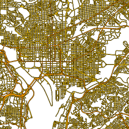
Этот набор данных TIGER Бюро переписи населения США содержит все участки дорог из выпуска 2016 года, включающие более 19 миллионов отдельных линейных объектов, охватывающих Соединенные Штаты, округ Колумбия, Пуэрто-Рико и островные территории . Каждый объект представляет собой геометрию участка дороги (единый проходимый линейный путь, соединенный как минимум с одним перекрестком).
Полную техническую информацию обо всех продуктах TIGER 2016 см. в технической документации TIGER .
Схема таблицы
Схема таблицы
| Имя | Тип | Описание |
|---|---|---|
| полное имя | НИТЬ | Удобочитаемое название дороги |
| линейный идентификатор | НИТЬ | Основной идентификатор, используемый для ссылки на эту строку в других продуктах TIGER. |
| mtfcc | НИТЬ | Код приоритета дороги, обозначающий, например, основную, второстепенную, местную и т. д. |
| рттип | НИТЬ | Код типа маршрута, |
Условия эксплуатации
Условия эксплуатации
Бюро переписи населения США предоставляет часть своих общедоступных данных в машиночитаемом формате через программный интерфейс (API). Весь контент, документация, код и связанные с ними материалы, доступные через API, регулируются настоящими условиями .
Цитаты
При создании любых отчетов, публикаций, новых наборов данных, производных продуктов или услуг, полученных на основе этих данных, пользователям следует ссылаться на Бюро переписи населения США .
Исследуйте мир с помощью Earth Engine.
Редактор кода (JavaScript)
var dataset = ee.FeatureCollection('TIGER/2016/Roads');
var roads = dataset.style({color: '#4285F4', width: 1});
Map.setCenter(-73.99172, 40.74101, 12);
Map.addLayer(roads, {}, 'TIGER/2016/Roads');
Визуализируйте как FeatureView
FeatureView — это ускоренное представление FeatureCollection , доступное только для просмотра. Более подробную информацию можно найти в документации FeatureView .
Редактор кода (JavaScript)
var fvLayer = ui.Map.FeatureViewLayer('TIGER/2016/Roads_FeatureView');

var visParams = {
  color: '4285f4'
};

fvLayer.setVisParams(visParams);
fvLayer.setName('US census roads');

Map.setCenter(-73.99172, 40.74101, 14);
Map.add(fvLayer);