- ডেটাসেটের উপলভ্যতা
- 2016-01-01T00:00:00Z–2017-01-02T00:00:00Z
- ডেটাসেট প্রযোজক
- মার্কিন যুক্তরাষ্ট্রের আদমশুমারি ব্যুরো
- ট্যাগ
বিবরণ
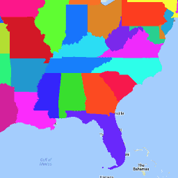
মার্কিন যুক্তরাষ্ট্রের আদমশুমারি ব্যুরো TIGER ডেটাসেটে মার্কিন যুক্তরাষ্ট্রের প্রাথমিক সরকারি বিভাগগুলির জন্য ২০১৬ সালের সীমানা রয়েছে। পঞ্চাশটি রাজ্য ছাড়াও, আদমশুমারি ব্যুরো কলম্বিয়া জেলা, পুয়ের্তো রিকো এবং প্রতিটি দ্বীপ অঞ্চল (আমেরিকান সামোয়া, উত্তর মারিয়ানা দ্বীপপুঞ্জের কমনওয়েলথ, গুয়াম এবং মার্কিন ভার্জিন দ্বীপপুঞ্জ) কে তথ্য উপস্থাপনের উদ্দেশ্যে রাজ্যগুলির পরিসংখ্যানগত সমতুল্য হিসাবে বিবেচনা করে। প্রতিটি বৈশিষ্ট্য একটি রাজ্য বা রাজ্যের সমতুল্য প্রতিনিধিত্ব করে।
TIGER 2016 এর সকল পণ্যের সম্পূর্ণ প্রযুক্তিগত বিবরণের জন্য, TIGER এর প্রযুক্তিগত ডকুমেন্টেশন দেখুন।
টেবিল স্কিমা
টেবিল স্কিমা
| নাম | আদর্শ | বিবরণ |
|---|---|---|
| আল্যান্ড | দ্বিগুণ | জমির পরিমাণ |
| জল | দ্বিগুণ | জল এলাকা |
| বিভাগ | স্ট্রিং | বিভাগ কোড |
| ফাংশনস্ট্যাট | স্ট্রিং | কার্যকরী অবস্থা |
| জিওআইডি | স্ট্রিং | রাজ্য শনাক্তকারী; রাজ্য FIPS কোড |
| ইন্টিপটল্যাট | স্ট্রিং | অভ্যন্তরীণ বিন্দু অক্ষাংশ |
| INTPTLON সম্পর্কে | স্ট্রিং | অভ্যন্তরীণ বিন্দু দ্রাঘিমাংশ |
| এলএসএডি | স্ট্রিং | রাজ্যের আইনি/পরিসংখ্যানগত এলাকার বর্ণনা |
| এমটিএফসিসি | স্ট্রিং | MAF/TIGER বৈশিষ্ট্য ক্লাস কোড (=G4000) |
| NAME এর | স্ট্রিং | রাজ্যের নাম |
| অঞ্চল | স্ট্রিং | অঞ্চল কোড |
| স্টেটএফপি | স্ট্রিং | রাজ্য FIPS কোড |
| স্ট্যাটেন্স | স্ট্রিং | রাজ্য GNIS কোড |
| স্টাস্পস | স্ট্রিং | মার্কিন ডাক পরিষেবা রাজ্যের সংক্ষিপ্ত রূপ |
ব্যবহারের শর্তাবলী
ব্যবহারের শর্তাবলী
মার্কিন আদমশুমারি ব্যুরো তার কিছু পাবলিক ডেটা একটি অ্যাপ্লিকেশন প্রোগ্রামিং ইন্টারফেস (API) এর মাধ্যমে মেশিন-পঠনযোগ্য ফর্ম্যাটে অফার করে। API এর মাধ্যমে উপলব্ধ সমস্ত বিষয়বস্তু, ডকুমেন্টেশন, কোড এবং সম্পর্কিত উপকরণ এই শর্তাবলীর অধীন।
উদ্ধৃতি
ডেটা সেট থেকে প্রাপ্ত যেকোনো প্রতিবেদন, প্রকাশনা, নতুন ডেটা সেট, প্রাপ্ত পণ্য বা পরিষেবা তৈরির জন্য ব্যবহারকারীদের মার্কিন আদমশুমারি ব্যুরো উল্লেখ করা উচিত।
আর্থ ইঞ্জিনের সাহায্যে ঘুরে দেখুন
কোড এডিটর (জাভাস্ক্রিপ্ট)
var dataset = ee.FeatureCollection('TIGER/2016/States');
var visParams = {
  palette: ['purple', 'blue', 'green', 'yellow', 'orange', 'red'],
  min: 500000000,
  max: 5e+11,
  opacity: 0.8,
};
var image = ee.Image().float().paint(dataset, 'ALAND');
Map.setCenter(-99.844, 37.649, 5);
Map.addLayer(image, visParams, 'TIGER/2016/States');
Map.addLayer(dataset, null, 'for Inspector', false);
একটি FeatureView হিসেবে ভিজ্যুয়ালাইজ করুন
FeatureView হল FeatureCollection এর একটি ত্বরিত উপস্থাপনা যা কেবলমাত্র দেখার জন্য। আরও বিস্তারিত জানার জন্য, FeatureView ডকুমেন্টেশনটি দেখুন।
কোড এডিটর (জাভাস্ক্রিপ্ট)
var fvLayer = ui.Map.FeatureViewLayer('TIGER/2016/States_FeatureView');

var visParams = {
  opacity: 0.8,
  color: {
    property: 'ALAND',
    mode: 'linear',
    palette: ['purple', 'blue', 'green', 'yellow', 'orange', 'red'],
    min: 5e8,
    max: 5e11
  }
};

fvLayer.setVisParams(visParams);
fvLayer.setName('US census states');

Map.setCenter(-99.844, 37.649, 5);
Map.add(fvLayer);