- Доступность набора данных
- 1998-01-01T00:00:00Z–2019-12-01T00:00:00Z
- Поставщик наборов данных
- NASA GES DISC в Центре космических полетов имени Годдарда NASA
- Каденция
- 1 месяц
- Теги
Описание
Эта коллекция больше не обновляется. Смотрите IMERG ежемесячно.
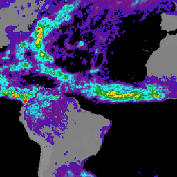
Этот набор данных алгоритмически объединяет микроволновые данные с нескольких спутников, включая SSMI, SSMIS, MHS, AMSU-B и AMSR-E, каждый из которых взаимно откалиброван с помощью комбинированного прибора TRMM.
Алгоритм 3B43 выполняется один раз в календарный месяц для получения единого наилучшего оценочного значения интенсивности осадков и поля оценки среднеквадратической ошибки осадков (3B43) путем объединения 3-часовых объединенных высококачественных/IR оценок (3B42) с ежемесячным накопленным анализом дождемеров Глобального центра климатологии осадков (GPCC).
Все глобальные наборы данных об осадках имеют калибровочный источник данных, необходимый для контроля разницы в смещениях между участвующими спутниками. Многоспутниковые данные усредняются по месячной шкале и объединяются с ежемесячным анализом данных осадкомеров Глобального центра климатологии осадков (GPCC). В каждом случае многоспутниковые данные корректируются по среднему значению анализа осадкомеров по большой площади, если оно доступно (в основном над сушей), а затем объединяются с анализом осадкомеров с помощью простого обратного взвешивания дисперсии оцененной случайной ошибки. Регионы с плохим покрытием осадкомеров, такие как Центральная Африка и океаны, имеют более высокий вес данных спутниковых данных.
Подробности смотрите в описании алгоритма и спецификации файла .
Группы
Размер пикселя
27830 метров
Группы
| Имя | Единицы | Мин. | Макс | Размер пикселя | Описание |
|---|---|---|---|---|---|
precipitation | мм/ч | 0* | 6.73* | метров | Объединенная оценка осадков по данным микроволнового и ИК-излучения |
relativeError | мм/ч | 0,001* | 16.36* | метров | Оценка случайной погрешности комбинированного микроволнового/ИК-излучения осадков |
gaugeRelativeWeighting | % | 0* | 100* | метров | Относительное взвешивание дождемеров, используемых при калибровке |
Условия эксплуатации
Условия эксплуатации
Этот набор данных находится в открытом доступе и доступен без ограничений на использование и распространение. Дополнительную информацию см. в Политике NASA в отношении данных и информации о науках о Земле .
Цитаты
Adler, RF, GJ Huffman, A. Chang, R. Ferraro, P. Xie, J. Janowiak, B. Rudolf, U. Schneider, S. Curtis, D. Bolvin, A. Gruber, J. Susskind, P. Arkin, EJ Nelkin, 2003: Ежемесячный анализ осадков версии 2 Глобального проекта по климатологии осадков (GPCP) (с 1979 г. по настоящее время). J. Hydrometeor., 4(6), 1147-1167.
Хаффман, Г.Дж., 1997: Оценки среднеквадратической случайной ошибки для конечных выборок оценочных осадков, J. Appl. Meteor., 1191-1201.
Хаффман, Г.Дж., 2012: Теоретический базовый документ алгоритма (ATBD), версия 3.0, для интегрированного многоспутникового поиска данных NASA Global Precipitation Measurement (GPM) для GPM (I-MERG). Проект GPM, Гринбелт, Мэриленд, 29 стр.
Хаффман, Г. Дж., Р. Ф. Адлер, П. Аркин, А. Чанг, Р. Ферраро, А. Грубер, Дж. Яновяк, А. Макнаб, Б. Рудольф и У. Шнайдер, 1997: Объединенный набор данных об осадках Глобального проекта по климатологии осадков (GPCP), Bull. Amer. Meteor. Soc., 78, 5-20.
Хаффман, Г.Дж., Р.Ф. Адлер, Д.Т. Болвин, Г. Гу, Э.Дж. Нелкин, К.П. Боуман, И. Хонг, Э.Ф. Стокер, Д.Б. Вольф, 2007: Многоспутниковый анализ осадков TRMM: квазиглобальные, многолетние, комбинированные оценки осадков в мелком масштабе. J. Hydrometeor., 8(1), 38-55.
Хаффман, Г.Дж., Р.Ф. Адлер, М. Моррисси, Д.Т. Болвин, С. Кёртис, Р. Джойс, Б. МакГавок, Дж. Сасскинд, 2001: Глобальные осадки с ежедневным разрешением в один градус по данным многоспутниковых наблюдений. Гидрометеорологический журнал, 2(1), 36-50.
Хаффман, Г.Дж., Р.Ф. Адлер, Б. Рудольф, У. Шнайдер и П. Кин, 1995: Глобальные оценки осадков, основанные на методе объединения оценок, полученных со спутников, анализа дождемеров и информации об осадках, полученной с помощью модели ЧПП, J. Clim., 8, 1284-1295.
Исследуйте с Earth Engine
Редактор кода (JavaScript)
var dataset = ee.ImageCollection('TRMM/3B43V7')
                  .filter(ee.Filter.date('2018-04-01', '2018-05-01'));
var precipitation = dataset.select('precipitation');
var precipitationVis = {
  min: 0.1,
  max: 1.2,
  palette: ['blue', 'purple', 'cyan', 'green', 'yellow', 'red'],
};
Map.setCenter(6.746, 46.529, 3);
Map.addLayer(precipitation, precipitationVis, 'Precipitation');