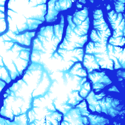
ArcticDEM to inicjatywa publiczno-prywatna Agencji Wywiadu Geoprzestrzennego (NGA) i Narodowej Fundacji Nauki (NSF), której celem jest automatyczne tworzenie wysokiej jakości cyfrowego modelu powierzchni (DSM) Arktyki o wysokiej rozdzielczości przy użyciu optycznych zdjęć stereoskopowych, komputerów o dużej mocy obliczeniowej i oprogramowania fotogrametrycznego typu open source. Obejmuje on roślinność, korony drzew, budynki i inne elementy powierzchni stworzone przez człowieka. Zasób o rozdzielczości 2 m to zbiór pasów, a nie pojedyncza mozaika, ze względu na różnice w projekcji między pasami.
Pliki DEM w postaci pasów odpowiadają obszarowi nakładania się pasów obrazów wejściowej pary stereo, które są zbierane przez konstelację satelitów DigitalGlobe na orbitach polarnych. Wymiary cyfrowego modelu terenu będą się różnić w zależności od czujnika satelitarnego, który zarejestrował obrazy, oraz kąta odchylenia od zenitu. Większość pasów ma szerokość od 16 km do 18 km i długość od 110 km do 120 km.
Pasma
Rozmiar piksela 2 metry
Pasma
Nazwa
Jednostki
Rozmiar piksela
Opis
elevation
m
metry
Wysokość
matchtag
metry
Rastrowa maska bitowa wskazująca przetwarzanie pikseli DEM
Bitmaska dla tagu dopasowania
Bit 0: przetwarzanie pikseli
0: piksele zostały interpolowane.
1. Piksele pochodzą z dopasowania stereo
Warunki korzystania z usługi
Zasady National Science Foundation (głównego źródła finansowania PGC) wymagają, aby naukowcy podawali informacje o wsparciu ze strony NSF we wszystkich publikacjach, stronach internetowych i wywiadach w mediach.
Korzystając z danych PGC w Earth Engine, użytkownicy zgadzają się na podawanie źródła PGC i informacji o jego sponsorowaniu przez NSF. Należy też odpowiednio podać oryginalne źródło wszelkich danych osób trzecich dostarczonych przez PGC.
ArcticDEM to inicjatywa publiczno-prywatna Agencji Wywiadu Geoprzestrzennego Stanów Zjednoczonych (NGA) i Narodowej Fundacji Nauki (NSF), której celem jest automatyczne tworzenie wysokiej jakości cyfrowego modelu powierzchni (DSM) Arktyki o wysokiej rozdzielczości przy użyciu optycznych zdjęć stereoskopowych, komputerów o dużej mocy obliczeniowej i oprogramowania do fotogrametrii o otwartym kodzie źródłowym. Obejmuje roślinność, korony drzew, budynki i inne obiekty stworzone przez człowieka. …
[null,null,[],[[["\u003cp\u003eArcticDEM provides a high-resolution (2m) digital surface model (DSM) of the Arctic, including vegetation, buildings, and other surface features.\u003c/p\u003e\n"],["\u003cp\u003eIt is created from optical stereo imagery using high-performance computing and open source photogrammetry software.\u003c/p\u003e\n"],["\u003cp\u003eThe dataset is a collection of strips covering the Arctic region from 2009 to 2017, with varying dimensions depending on the satellite sensor and collection angle.\u003c/p\u003e\n"],["\u003cp\u003eUsers must acknowledge NSF support and cite PGC when using this data, as per the terms of use.\u003c/p\u003e\n"],["\u003cp\u003eData can be explored and analyzed using Google Earth Engine, a platform for scientific analysis and visualization of geospatial datasets.\u003c/p\u003e\n"]]],["The ArcticDEM dataset, provided by the University of Minnesota Polar Geospatial Center, offers a high-resolution digital surface model (DSM) of the Arctic from 2009 to 2017. Utilizing stereo imagery and photogrammetry, it captures surface features with a 2-meter pixel size. Data is in strips and includes elevation data and a matchtag for pixel processing information. The dataset, accessible via Google Earth Engine, requires NSF acknowledgment and appropriate citations for use.\n"],null,["# ArcticDEM Strips\n\nDataset Availability\n: 2009-08-16T00:00:00Z--2017-03-12T00:00:00Z\n\nDataset Provider\n:\n\n\n [University of Minnesota Polar Geospatial Center](https://www.pgc.umn.edu/data/arcticdem/)\n\nTags\n:\n[arctic](/earth-engine/datasets/tags/arctic) [dem](/earth-engine/datasets/tags/dem) [elevation-topography](/earth-engine/datasets/tags/elevation-topography) [geophysical](/earth-engine/datasets/tags/geophysical) [pgc](/earth-engine/datasets/tags/pgc) [umn](/earth-engine/datasets/tags/umn) \n\n#### Description\n\nArcticDEM is a National Geospatial-Intelligence Agency (NGA) and National\nScience Foundation (NSF) public-private initiative to automatically produce\na high-resolution, high-quality digital surface model (DSM) of the Arctic\nusing optical stereo imagery, high-performance computing, and open source\nphotogrammetry software. It includes vegetation, tree canopy, buildings, and\nother man-made surface features. The 2m asset is a collection of strips rather\nthan a single mosaic due to projection differences between strips.\n\nStrip DEM files correspond to the overlapping area of the input stereopair\nimage swaths as they are collected by DigitalGlobe's constellation of\npolar-orbiting satellites. Strip DEM dimensions will vary according to the\nsatellite sensor that acquired the images and the off-nadir angle of\ncollection. Most strips are between 16km and 18km in width, and 110km and\n120km in length.\n\n### Bands\n\n\n**Pixel Size**\n\n2 meters\n\n**Bands**\n\n| Name | Units | Pixel Size | Description |\n|-------------|-------|------------|-------------------------------------------------|---|---|---|---|---|---|---|---|---|---|---|---|---|---|---|---|---|---|---|---|---|---|---|---|---|---|---|---|---|---|---|---|---|---|---|---|---|---|---|---|---|---|---|---|---|---|---|---|---|---|---|---|---|---|---|---|---|---|---|---|---|---|---|---|---|---|---|---|---|---|---|---|---|---|---|---|---|---|---|---|---|---|---|---|---|---|---|---|---|---|---|---|---|---|---|---|\n| `elevation` | m | meters | Elevation |\n| `matchtag` | | meters | Bitmask raster indicating DEM pixels processing |\n| Bitmask for matchtag - Bit 0: Pixel processing - 0: Pixels have been interpolated - 1: Pixels are derived from a stereo match ||||||||||||||||||||||||||||||||||||||||||||||||||||||||||||||||||||||||||||||||||||||||||||||||||||\n\n### Terms of Use\n\n**Terms of Use**\n\nNational Science Foundation (PGC's primary funding source) policy requires\nresearchers to acknowledge NSF support in all publications, web pages, and\nmedia interviews.\n\nBy using PGC data in Earth Engine, users agree to cite PGC\nand its sponsorship by the NSF. The original source of any third-party data\nsupplied by PGC must also be properly attributed.\n\nFor more information see the PGC's\n[Acknowledgement Policy](https://www.pgc.umn.edu/guides/user-services/acknowledgement-policy/).\n\n### Citations\n\nCitations:\n\n- DEM(s) created by the Polar Geospatial Center from DigitalGlobe, Inc. imagery.\n Porter, Claire; Morin, Paul; Howat, Ian; Noh, Myoung-Jon; Bates, Brian;\n Peterman, Kenneth; Keesey, Scott; Schlenk, Matthew; Gardiner, Judith;\n Tomko, Karen; Willis, Michael; Kelleher, Cole; Cloutier, Michael; Husby, Eric;\n Foga, Steven; Nakamura, Hitomi; Platson, Melisa; Wethington, Michael, Jr.;\n Williamson, Cathleen; Bauer, Gregory; Enos, Jeremy; Arnold, Galen; Kramer, William;\n Becker, Peter; Doshi, Abhijit; D'Souza, Cristelle; Cummens, Pat; Laurier, Fabien;\n Bojesen, Mikkel, 2018, ArcticDEM, Harvard Dataverse, V1, \\[Date Accessed\\].\n\n### DOIs\n\n- \u003chttps://doi.org/10.7910/DVN/OHHUKH\u003e\n\n### Explore with Earth Engine\n\n| **Important:** Earth Engine is a platform for petabyte-scale scientific analysis and visualization of geospatial datasets, both for public benefit and for business and government users. Earth Engine is free to use for research, education, and nonprofit use. To get started, please [register for Earth Engine access.](https://console.cloud.google.com/earth-engine)\n\n### Code Editor (JavaScript)\n\n```javascript\nvar dataset = ee.ImageCollection('UMN/PGC/ArcticDEM/V3/2m');\nvar elevation = dataset.select('elevation');\nvar elevationVis = {\n min: -50.0,\n max: 1000.0,\n palette: ['0d13d8', '60e1ff', 'ffffff'],\n};\nMap.setCenter(-63.402, 66.368, 7);\nMap.addLayer(elevation, elevationVis, 'Elevation');\n```\n[Open in Code Editor](https://code.earthengine.google.com/?scriptPath=Examples:Datasets/UMN/UMN_PGC_ArcticDEM_V3_2m) \n[ArcticDEM Strips](/earth-engine/datasets/catalog/UMN_PGC_ArcticDEM_V3_2m) \nArcticDEM is a National Geospatial-Intelligence Agency (NGA) and National Science Foundation (NSF) public-private initiative to automatically produce a high-resolution, high-quality digital surface model (DSM) of the Arctic using optical stereo imagery, high-performance computing, and open source photogrammetry software. It includes vegetation, tree canopy, buildings, and other man-made surface features. The ... \nUMN/PGC/ArcticDEM/V3/2m, arctic,dem,elevation-topography,geophysical,pgc,umn \n2009-08-16T00:00:00Z/2017-03-12T00:00:00Z \n50 -180 90 180 \nGoogle Earth Engine \nhttps://developers.google.com/earth-engine/datasets\n\n- [https://doi.org/10.7910/DVN/OHHUKH](https://doi.org/https://www.pgc.umn.edu/data/arcticdem/)\n- [https://doi.org/10.7910/DVN/OHHUKH](https://doi.org/https://developers.google.com/earth-engine/datasets/catalog/UMN_PGC_ArcticDEM_V3_2m)"]]