- ডেটাসেট উপলব্ধতা
- 1986-01-01T00:00:00Z–2021-12-19T00:00:00Z
- ডেটাসেট প্রদানকারী
- ইউনিভার্সিটি অফ মন্টানা নিউমেরিক্যাল টেরাডাইনামিক সিমুলেশন গ্রুপ (NTSG)
- ক্যাডেন্স
- 16 দিন
- ট্যাগ
বর্ণনা
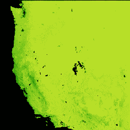
ল্যান্ডস্যাট গ্রস প্রাইমারি প্রোডাকশন (GPP) CONUS ডেটাসেট CONUS-এর জন্য Landsat Surface Reflectance ব্যবহার করে GPP অনুমান করে। জিপিপি হল একটি বাস্তুতন্ত্রে গাছপালা দ্বারা ক্যাপচার করা কার্বনের পরিমাণ এবং নেট প্রাইমারি প্রোডাকশনের (এনপিপি) গণনার একটি অপরিহার্য উপাদান। GPP গণনা করা হয় MOD17 অ্যালগরিদম ব্যবহার করে ( MOD17 ব্যবহারকারীর নির্দেশিকা দেখুন) Landsat Surface Reflectance, gridMET, এবং ন্যাশনাল ল্যান্ড কভার ডেটাবেস সহ।
ব্যান্ড
পিক্সেল সাইজ
30 মিটার
ব্যান্ড
| নাম | ইউনিট | মিন | সর্বোচ্চ | স্কেল | পিক্সেল সাইজ | বর্ণনা |
|---|---|---|---|---|---|---|
GPP | kg*C/m^2/16-দিন | 0 | 65535 | 0.0001 | মিটার | 16 দিনের মোট প্রাথমিক উৎপাদন |
QC | মিটার | GPP গণনায় ব্যবহৃত Landsat NDVI পিক্সেলের গুণমান নির্দেশ করে |
QC ক্লাস টেবিল
| মান | রঙ | বর্ণনা |
|---|---|---|
| 10 | #e6194b | পরিষ্কার না মসৃণ |
| 11 | #3cb44b | পরিষ্কার মসৃণ |
| 20 | #ffe119 | তুষার বা জল মসৃণ না |
| 21 | #4363d8 | তুষার বা জল মসৃণ |
| 30 | #f58231 | জলবায়ুবিদ্যা মসৃণ না |
| 31 | #911eb4 | জলবায়ুবিদ্যা মসৃণ |
| 40 | #46f0f0 | ফাঁক ভরাট মসৃণ না |
| 41 | #f032e6 | ফাঁক ভরাট মসৃণ |
ব্যবহারের শর্তাবলী
ব্যবহারের শর্তাবলী
এই কাজটি সর্বজনীন ডোমেনে রয়েছে এবং পরিচিত কপিরাইট বিধিনিষেধমুক্ত। ব্যবহারকারীদের উচিত এই ডেটাসেট ব্যবহারের ফলে যেকোন প্রতিবেদন এবং প্রকাশনা তৈরিতে ব্যবহৃত উৎসটি সঠিকভাবে উদ্ধৃত করা এবং ডেটা কখন অর্জিত হয়েছিল তা নোট করা উচিত।
উদ্ধৃতি
রবিনসন, এনপি, বিডব্লিউ অলরেড, ডব্লিউ কে স্মিথ, এমও জোন্স, এ. মোরেনো, টিএ এরিকসন, ডি নগল, এবং এসডব্লিউ রানিং। 2018. ল্যান্ডস্যাট 30 মিটার এবং MODIS 250 মিটার থেকে প্রাপ্ত বিপর্যস্ত মার্কিন যুক্তরাষ্ট্রের জন্য স্থলজ প্রাথমিক উৎপাদন। বাস্তুবিদ্যা এবং সংরক্ষণে রিমোট সেন্সিং। doi:10.1002/rse2.74
আর্থ ইঞ্জিন দিয়ে অন্বেষণ করুন
কোড এডিটর (জাভাস্ক্রিপ্ট)
var dataset = ee.ImageCollection('UMT/NTSG/v2/LANDSAT/GPP')
                  .filter(ee.Filter.date('2017-05-01', '2017-05-31'));
var gpp = dataset.select('GPP');
var gppVis = {
  min: 0.0,
  max: 1000.0,
  palette: ['bbe029', '0a9501', '074b03'],
};
Map.setCenter(-98.26, 39.32, 5);
Map.addLayer(gpp, gppVis, 'GPP');