- Disponibilidad del conjunto de datos
- 2003-07-23T00:00:00Z–2025-04-08T00:00:00Z
- Proveedor del conjunto de datos
- United States Geological Survey
- Etiquetas
Descripción
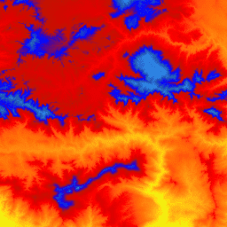
Esta es una colección de imágenes en mosaicos con un tamaño de píxel de 1 m del Programa de elevación 3D (3DEP). Las existencias de datos de 3DEP sirven como capa de elevación de The National Map y proporcionan información de elevación fundamental para estudios de ciencias de la Tierra y aplicaciones de mapas en Estados Unidos.
Las elevaciones en este DEM representan la superficie topográfica de la Tierra sin vegetación. Los DEM estándar de 1 m de tamaño de píxel del USGS se producen exclusivamente a partir de datos de origen de detección de luz y rango (lidar) de alta resolución de imágenes con un tamaño de píxel de 1 m o una resolución superior. Las superficies DEM de 1 m de tamaño de píxel son continuas dentro de los proyectos de recopilación, pero no necesariamente en todos los proyectos. La referencia espacial que se usa para los mosaicos del DEM de 1 m de tamaño de píxel dentro de los Estados Unidos contiguos (CONUS) es la Universal Transverse Mercator (UTM) en unidades de metros y de conformidad con el North American Datum de 1983 (NAD83). Todos los valores de elevación de la Tierra sin vegetación están en metros y se hace referencia al North American Vertical Datum de 1988 (NAVD88). Cada mosaico se distribuye en la zona UTM en la que se encuentra. Si un mosaico cruza dos zonas UTM, se entrega en ambas zonas. En este y otros casos de superposición de imágenes, los valores de elevación pueden ser ligeramente diferentes en las distintas imágenes que cubren la misma área.
El DEM de 1 m de tamaño de píxel es el DEM estándar de mayor resolución que se ofrece en el conjunto de productos 3DEP. El conjunto de datos 3DEP de 10 m está disponible en USGS_3DEP_10m_collection.
Bandas
Bandas
Tamaño de los píxeles: 1 metro (todas las bandas)
| Nombre | Unidades | Tamaño de los píxeles | Descripción |
|---|---|---|---|
elevation |
m | 1 metro | Elevación (NAVD88) |
Condiciones de Uso
Condiciones de Uso
La mayor parte de la información del Servicio Geológico de los Estados Unidos (USGS) pertenece al dominio público y se puede usar sin restricciones. Hay información adicional disponible sobre cómo reconocer o atribuir al USGS como fuente de información.
Citas
U.S. Geological Survey, 3D Elevation Program 1-Meter Resolution Digital Elevation Model.
Explora con Earth Engine
Editor de código (JavaScript)
var dataset = ee.ImageCollection('USGS/3DEP/1m');
var visualization = {
  min: 0,
  max: 3000,
  palette: [
    '3ae237', 'b5e22e', 'd6e21f', 'fff705', 'ffd611', 'ffb613', 'ff8b13',
    'ff6e08', 'ff500d', 'ff0000', 'de0101', 'c21301', '0602ff', '235cb1',
    '307ef3', '269db1', '30c8e2', '32d3ef', '3be285', '3ff38f', '86e26f'
  ],
};
Map.setCenter(-119.0, 34.6, 10);
Map.addLayer(dataset, visualization, 'elevation');