HydroSHEDS to produkt mapowy, który zawiera informacje hydrograficzne do zastosowań regionalnych i globalnych w spójnym formacie. Zawiera on zestaw danych geograficznych (wektorowych i rastrowych) w różnych skalach, w tym sieci rzeczne, granice zlewni, kierunki odpływu i akumulację przepływu. HydroSHEDS
opiera się na danych o wysokości uzyskanych w 2000 roku przez misję Shuttle Radar
Topography Mission (SRTM) NASA.
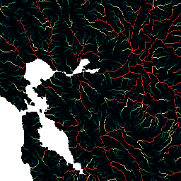
Ten zbiór danych dotyczący akumulacji przepływu określa wielkość obszaru powyżej (w liczbie komórek) odprowadzającego wodę do każdej komórki. Warstwa kierunku spływu służy do określania komórek, z których woda spływa do komórki docelowej. Liczba zgromadzonych komórek jest w zasadzie miarą obszaru zlewni powyżej danego punktu. Jednak ponieważ rozmiar komórki zbioru danych HydroSHEDS zależy od szerokości geograficznej, wartość akumulacji komórek nie może być bezpośrednio przeliczana na obszary zlewni w kilometrach kwadratowych. Wartości wahają się od 1 w przypadku wyżyn topograficznych (źródeł rzek) do bardzo dużych liczb (rzędu milionów komórek) w przypadku ujść dużych rzek.
Ten zbiór danych ma rozdzielczość 15 sekund łuku. Zbiory danych dostępne w rozdzielczości 15 sekund łuku to Hydrologically Conditioned DEM, Drainage (Flow) Direction i Flow Accumulation.
Jakość danych HydroSHEDS jest znacznie niższa w przypadku regionów położonych powyżej 60 stopni szerokości geograficznej północnej, ponieważ nie ma dostępnych danych o wysokości SRTM, a zatem zastosowano model DEM o niższej rozdzielczości (HYDRO1k dostarczony przez USGS).
HydroSHEDS został opracowany przez program ochrony przyrody World Wildlife Fund (WWF) we współpracy z U.S. Geological Survey, International Centre for Tropical Agriculture, The Nature Conservancy i Center for Environmental Systems Research na Uniwersytecie w Kassel w Niemczech.
Pasma
Rozmiar piksela 463,83 m
Pasma
Nazwa
Minimum
Maks.
Rozmiar piksela
Opis
b1
1*
2,78651e+07*
metry
Akumulacja przepływu
* szacowana wartość minimalna lub maksymalna
Warunki korzystania z usługi
Dane HydroSHEDS są dostępne bezpłatnie do użytku niekomercyjnego i komercyjnego. Więcej informacji znajdziesz w umowie licencyjnej.
Cytaty
Cytowania:
Lehner, B., Verdin, K., Jarvis, A. (2008): New global hydrography
derived from spaceborne elevation data. Eos, Transactions, AGU,
89(10): 93-94.
HydroSHEDS to produkt mapowy, który zawiera informacje hydrograficzne do zastosowań regionalnych i globalnych w spójnym formacie. Zawiera zestaw danych geograficznych (wektorowych i rastrowych) w różnych skalach, w tym sieci rzeczne, granice zlewni, kierunki odpływu i akumulację przepływu. HydroSHEDS opiera się na danych o wysokości uzyskanych w 2000 roku…
WWF/HydroSHEDS/15ACC,
akumulacja,drenaż,przepływ,geofizyka,hydrografia,hydrologia,hydrosheds,srtm,woda powierzchniowa i gruntowa,woda,wwf
[null,null,[],[[["\u003cp\u003eHydroSHEDS provides hydrographic information like river networks, watershed boundaries, and flow accumulation, globally at various scales.\u003c/p\u003e\n"],["\u003cp\u003eThis dataset, at 15 arc-second resolution, specifically represents the amount of upstream area draining into each cell, derived from SRTM elevation data.\u003c/p\u003e\n"],["\u003cp\u003eData quality is lower above 60 degrees northern latitude due to reliance on coarser-resolution DEM.\u003c/p\u003e\n"],["\u003cp\u003eHydroSHEDS data is free for both non-commercial and commercial use under the provided license agreement.\u003c/p\u003e\n"],["\u003cp\u003eDeveloped by WWF in partnership with USGS, CIAT, TNC, and the University of Kassel.\u003c/p\u003e\n"]]],[],null,["# WWF HydroSHEDS Flow Accumulation, 15 Arc-Seconds\n\nDataset Availability\n: 2000-02-11T00:00:00Z--2000-02-22T00:00:00Z\n\nDataset Provider\n:\n\n\n [WWF](https://www.hydrosheds.org/)\n\nTags\n:\n[accumulation](/earth-engine/datasets/tags/accumulation) [drainage](/earth-engine/datasets/tags/drainage) [flow](/earth-engine/datasets/tags/flow) [geophysical](/earth-engine/datasets/tags/geophysical) [hydrography](/earth-engine/datasets/tags/hydrography) [hydrology](/earth-engine/datasets/tags/hydrology) [hydrosheds](/earth-engine/datasets/tags/hydrosheds) [srtm](/earth-engine/datasets/tags/srtm) [surface-ground-water](/earth-engine/datasets/tags/surface-ground-water) [water](/earth-engine/datasets/tags/water) [wwf](/earth-engine/datasets/tags/wwf) \n\n#### Description\n\nHydroSHEDS is a mapping product that provides hydrographic\ninformation for regional and global-scale applications in a consistent\nformat. It offers a suite of geo-referenced datasets (vector and\nraster) at various scales, including river networks, watershed\nboundaries, drainage directions, and flow accumulations. HydroSHEDS\nis based on elevation data obtained in 2000 by NASA's Shuttle Radar\nTopography Mission (SRTM).\n\nThis flow accumulation dataset defines the amount of\nupstream area (in number of cells) draining into each cell. The\ndrainage direction layer is used to define which cells flow into\nthe target cell. The number of accumulated cells is essentially\na measure of the upstream catchment area. However, since the\ncell size of the HydroSHEDS data set depends on latitude, the\ncell accumulation value cannot directly be translated into drainage\nareas in square kilometers. Values range from 1 at topographic\nhighs (river sources) to very large numbers (on the order of\nmillions of cells) at the mouths of large rivers.\n\nThis dataset is at 15 arc-second resolution. The datasets available\nat 15 arc-seconds are the Hydrologically Conditioned DEM, Drainage\n(Flow) Direction, and Flow Accumulation.\n\nNote that the quality of the HydroSHEDS data is significantly lower for regions above\n60 degrees northern latitude as there is no underlying SRTM elevation data available\nand thus a coarser-resolution DEM was (HYDRO1k provided by USGS).\n\nHydroSHEDS was developed by the World Wildlife Fund (WWF)\nConservation Science Program in partnership with the U.S. Geological\nSurvey, the International Centre for Tropical Agriculture, The\nNature Conservancy, and the Center for Environmental Systems Research\nof the University of Kassel, Germany.\n\n### Bands\n\n\n**Pixel Size**\n\n463.83 meters\n\n**Bands**\n\n| Name | Min | Max | Pixel Size | Description |\n|------|-----|---------------|------------|-------------------|\n| `b1` | 1\\* | 2.78651e+07\\* | meters | Flow accumulation |\n\n\\* estimated min or max value\n\n### Terms of Use\n\n**Terms of Use**\n\nHydroSHEDS data are free for non-commercial and commercial\nuse. For more information, please refer to the [License Agreement](https://www.hydrosheds.org/page/license).\n\n### Citations\n\nCitations:\n\n- Lehner, B., Verdin, K., Jarvis, A. (2008): New global hydrography\n derived from spaceborne elevation data. Eos, Transactions, AGU,\n 89(10): 93-94.\n\n### Explore with Earth Engine\n\n| **Important:** Earth Engine is a platform for petabyte-scale scientific analysis and visualization of geospatial datasets, both for public benefit and for business and government users. Earth Engine is free to use for research, education, and nonprofit use. To get started, please [register for Earth Engine access.](https://console.cloud.google.com/earth-engine)\n\n### Code Editor (JavaScript)\n\n```javascript\nvar dataset = ee.Image('WWF/HydroSHEDS/15ACC');\nvar flowAccumulation = dataset.select('b1');\nvar flowAccumulationVis = {\n min: 0.0,\n max: 500.0,\n palette: [\n '000000', '023858', '006837', '1a9850', '66bd63', 'a6d96a', 'd9ef8b',\n 'ffffbf', 'fee08b', 'fdae61', 'f46d43', 'd73027'\n ],\n};\nMap.setCenter(-121.652, 38.022, 8);\nMap.addLayer(flowAccumulation, flowAccumulationVis, 'Flow Accumulation');\n```\n[Open in Code Editor](https://code.earthengine.google.com/?scriptPath=Examples:Datasets/WWF/WWF_HydroSHEDS_15ACC) \n[WWF HydroSHEDS Flow Accumulation, 15 Arc-Seconds](/earth-engine/datasets/catalog/WWF_HydroSHEDS_15ACC) \nHydroSHEDS is a mapping product that provides hydrographic information for regional and global-scale applications in a consistent format. It offers a suite of geo-referenced datasets (vector and raster) at various scales, including river networks, watershed boundaries, drainage directions, and flow accumulations. HydroSHEDS is based on elevation data obtained in 2000 ... \nWWF/HydroSHEDS/15ACC, accumulation,drainage,flow,geophysical,hydrography,hydrology,hydrosheds,srtm,surface-ground-water,water,wwf \n2000-02-11T00:00:00Z/2000-02-22T00:00:00Z \n-67.3 -180 62 180 \nGoogle Earth Engine \nhttps://developers.google.com/earth-engine/datasets\n\n- [](https://doi.org/https://www.hydrosheds.org/)\n- [](https://doi.org/https://developers.google.com/earth-engine/datasets/catalog/WWF_HydroSHEDS_15ACC)"]]