-
WWF HydroSHEDS Flow Accumulation, 15 sekund łuku
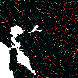
HydroSHEDS to produkt mapowy, który zawiera informacje hydrograficzne do zastosowań regionalnych i globalnych w spójnym formacie. Zawiera zestaw danych geograficznych (wektorowych i rastrowych) w różnych skalach, w tym sieci rzeczne, granice zlewni, kierunki odpływu i akumulację przepływu. HydroSHEDS opiera się na … akumulacja odpływ przepływ geofizyka hydrografia hydrologia -
WWF HydroSHEDS Flow Accumulation, 30 Arc-Seconds
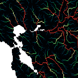
HydroSHEDS to produkt mapowy, który zawiera informacje hydrograficzne do zastosowań regionalnych i globalnych w spójnym formacie. Zawiera zestaw danych geograficznych (wektorowych i rastrowych) w różnych skalach, w tym sieci rzeczne, granice zlewni, kierunki odpływu i akumulację przepływu. HydroSHEDS opiera się na … akumulacja odpływ przepływ geofizyka hydrografia hydrologia
Datasets tagged accumulation in Earth Engine
[null,null,[],[],["HydroSHEDS is a mapping product delivering hydrographic data for both regional and global applications. It includes geo-referenced datasets in vector and raster formats. These datasets encompass river networks, watershed boundaries, drainage directions, and flow accumulations at varying scales. This product provides consistent hydrographic information by mapping the geophysical flow and drainage. The product is provided at both 15 and 30 arc-seconds resolution.\n"]]