הערה: מערך הנתונים הזה עדיין לא עבר ביקורת עמיתים. מידע נוסף זמין בקובץ ה-README ב-GitHub.
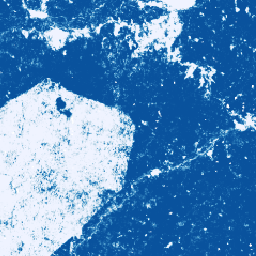
אוסף התמונות הזה מספק הסתברות משוערת לכל פיקסל לכך שהאזור הבסיסי מאוכלס על ידי הסחורה. אומדני ההסתברות מסופקים ברזולוציה של 10 מטר, והם נוצרו על ידי מודל למידת מכונה. פרטים נוספים זמינים במסמכי התיעוד הטכני בנושא מאגר השותפות לנתוני יערות ב-GitHub.
המטרה העיקרית של אוסף התמונות הזה היא לתמוך במשימה של השותפות לנתוני יערות, שמטרתה לעצור את אובדן היערות כתוצאה מייצור סחורות ולהפוך את המגמה הזו על ידי שיפור משותף של המעקב הגלובלי, מעקב שרשרת האספקה והשיקום.
נכון לעכשיו, מערך הנתונים הזה כולל את המדינות הבאות: חוף השנהב, גאנה, אינדונזיה, אקוודור, פרו וקולומביה.
המוצר הזה של נתוני הקהילה נועד להתפתח עם הזמן, ככל שיהיו יותר נתונים מהקהילה והמודל שמשמש ליצירת המפות ישתפר באופן מתמשך. אם ברצונך לשלוח משוב כללי או מערכי נתונים נוספים כדי לשפר את השכבות האלה, אפשר לעשות זאת באמצעות הטופס הזה.
מגבלות: פלט המודל מוגבל למדינות שנבחרו כנתונים מורכבים של שנת לוח לשנים 2020 ו-2023. לא כל האזורים בפלט מיוצגים היטב על ידי נתוני האימון. הדיוק מדווח בצורה מצטברת, והוא משתנה גיאוגרפית ובהתאם לסף שנקבע על ידי המשתמש. יכול להיות שיהיו ארטיפקטים של חיישנים על סמך זמינות הנתונים, אי-אחידות בין המסלולים או עננות, שיהיו גלויים בהסתברויות הפלט ויגרמו לשגיאות בסיווג בספים מסוימים.
הערה: לנתוני Earth Engine יש תנאי שימוש נפרדים למשתמשים מסחריים. פרטים נוספים מופיעים בכרטיסייה 'תנאי שימוש'.
תחום תדרים
גודל הפיקסל 10 מטרים
תחום תדרים
שם
מינימום
מקסימום
גודל הפיקסל
תיאור
probability
0
1
מטרים
ההסתברות שהפיקסל כולל עצי קקאו בשנה הנתונה.
תנאים והגבלות
תנאים והגבלות
משתמשים ב-Earth Engine למטרות לא מסחריות כפופים לרישיון CC-BY 4.0 NC, ונדרשים לתת את הקרדיט הבא: "נוצר על ידי Google עבור Forest Data Partnership".
הערה: מערך הנתונים הזה עדיין לא עבר ביקורת עמיתים. מידע נוסף זמין בקובץ README ב-GitHub. אוסף התמונות הזה מספק הסתברות משוערת לכל פיקסל לכך שהאזור הבסיסי מאוכלס על ידי הסחורה. ההערכות לגבי ההסתברות מסופקות ברזולוציה של 10 מטר, והן נוצרו על ידי מודל של למידת מכונה. ל…
[null,null,[],[],[],null,["# Cocoa Probability model 2025a\n\ninfo\n\n\nThis dataset is part of a Publisher Catalog, and not managed by Google Earth Engine.\n\nContact forestdatapartnership@googlegroups.com\n\nfor bugs or [view more datasets](https://developers.google.com/earth-engine/datasets/publisher/forestdatapartnership)\nfrom the Forest Data Partnership Catalog. [Learn more about Publisher datasets](/earth-engine/datasets/publisher). \n[](https://forestdatapartnership.org) \n\nCatalog Owner\n: Forest Data Partnership\n\nDataset Availability\n: 2020-01-01T00:00:00Z--2023-12-31T23:59:59Z\n\nDataset Provider\n:\n\n\n [Produced by Google for the Forest Data Partnership](https://www.forestdatapartnership.org/)\n\nTags\n:\n [agriculture](/earth-engine/datasets/tags/agriculture) [biodiversity](/earth-engine/datasets/tags/biodiversity) [conservation](/earth-engine/datasets/tags/conservation) [crop](/earth-engine/datasets/tags/crop) [eudr](/earth-engine/datasets/tags/eudr) [forestdatapartnership](/earth-engine/datasets/tags/forestdatapartnership) [landuse](/earth-engine/datasets/tags/landuse) [plantation](/earth-engine/datasets/tags/plantation) [pre-review](/earth-engine/datasets/tags/pre-review) [publisher-dataset](/earth-engine/datasets/tags/publisher-dataset) \ncocoa \n\n#### Description\n\n**Note: This dataset is not yet peer-reviewed. Please see this\n[GitHub README](https://github.com/google/forest-data-partnership/tree/main/models)\nfor more information.**\n\nThis image collection provides estimated per-pixel probability that the\nunderlying area is occupied by the commodity. The probability estimates are\nprovided at 10 meter resolution, and have been generated by a machine\nlearning model. For details, see the technical documentation on the\n[Forest Data Partnership repo](https://github.com/google/forest-data-partnership/tree/main)\non Github.\n\nThe primary purpose of this image collection is to support the mission of\nthe [Forest Data Partnership](https://www.forestdatapartnership.org/) which\naims to halt and reverse forest loss from commodity production by\ncollaboratively improving global monitoring, supply chain tracking, and\nrestoration.\n\nThis dataset currently covers the following countries: Côte d'Ivoire, Ghana,\nIndonesia, Ecuador, Peru, Colombia.\n\nThis community data product is meant to evolve over time, as more data\nbecomes available from the community and the model used to produce the maps\ncontinuously improves. If you would like to provide general feedback or\nadditional datasets to improve these layers, please reach out through\n[this form](https://goo.gle/fdap-data).\n\nLimitations: Model output is limited to selected countries as calendar year\ncomposites for 2020 and 2023. Not all regions of the output are well\nrepresented by training data. Accuracy is reported in aggregate, and will\nvary geographically and with user chosen thresholds. Sensor artifacts based\non data availability, cross-track nonuniformity, or cloudiness may be\nvisually apparent in output probabilities and result in classification\nerrors at some thresholds.\n\n**Note that this dataset has separate terms of use for commercial users of\nEarth Engine. Please see \"Terms of Use\" tab for details.**\n\n### Bands\n\n\n**Pixel Size**\n\n10 meters\n\n**Bands**\n\n| Name | Min | Max | Pixel Size | Description |\n|---------------|-----|-----|------------|---------------------------------------------------------------------|\n| `probability` | 0 | 1 | meters | Probability that the pixel includes cocoa trees for the given year. |\n\n### Terms of Use\n\n**Terms of Use**\n\nFor non-commercial users of Earth Engine, use of the dataset is subject to\nCC-BY 4.0 NC license and requires the following attribution:\n\"Produced by Google for the Forest Data Partnership\".\n\nFor commercial use of the dataset you may request access using\n[this form](https://docs.google.com/forms/d/e/1FAIpQLSe7L3eh6t2JIPqEtAQwXwY7ZmW52v8W5vrIi4QN_XYgTNJZLw/viewform?resourcekey=0-db8WFCPwr2AZRhnrnH2SFg).\nAccess will be granted or denied on a case-by-case basis. Commercial use of\nthe dataset is subject to the [Forest Data Partnership Datasets Commercial\nTerms of Use](https://services.google.com/fh/files/misc/forest_data_partnership_datasets_commerical_terms_of_use.pdf).\n\nContains modified Copernicus Sentinel data \\[2015-present\\]. See the\n[Sentinel Data Legal Notice](https://sentinels.copernicus.eu/documents/247904/690755/Sentinel_Data_Legal_Notice).\n\n### Citations\n\nCitations:\n\n- Forest Data Partnership. 2025. Community models 2025a. [Online](https://github.com/google/forest-data-partnership/tree/main/models/README.md)\n\n### Explore with Earth Engine\n\n| **Important:** Earth Engine is a platform for petabyte-scale scientific analysis and visualization of geospatial datasets, both for public benefit and for business and government users. Earth Engine is free to use for research, education, and nonprofit use. To get started, please [register for Earth Engine access.](https://console.cloud.google.com/earth-engine)\n\n### Code Editor (JavaScript)\n\n```javascript\nMap.setCenter(-7.67, 6.71, 11);\n\nvar collection = ee.ImageCollection(\n 'projects/forestdatapartnership/assets/cocoa/model_2025a');\n\nvar cocoa2020 = collection.filterDate('2020-01-01', '2020-12-31').mosaic();\nMap.addLayer(\n cocoa2020.selfMask(), {min: 0.5, max: 1, palette: 'white,blue'}, 'cocoa 2020');\n\nvar cocoa2023 = collection.filterDate('2023-01-01', '2023-12-31').mosaic();\nMap.addLayer(\n cocoa2023.selfMask(), {min: 0.5, max: 1, palette: 'white,green'}, 'cocoa 2023');\n```\n[Open in Code Editor](https://code.earthengine.google.com/?scriptPath=Examples:Datasets/forestdatapartnership/projects_forestdatapartnership_assets_cocoa_model_2025a) \n[Cocoa Probability model 2025a](/earth-engine/datasets/catalog/projects_forestdatapartnership_assets_cocoa_model_2025a) \nNote: This dataset is not yet peer-reviewed. Please see this GitHub README for more information. This image collection provides estimated per-pixel probability that the underlying area is occupied by the commodity. The probability estimates are provided at 10 meter resolution, and have been generated by a machine learning model. For ... \nprojects/forestdatapartnership/assets/cocoa/model_2025a, agriculture,biodiversity,conservation,crop,eudr,forestdatapartnership,landuse,plantation,pre-review,publisher-dataset \n2020-01-01T00:00:00Z/2023-12-31T23:59:59Z \n-90 -180 90 180 \nGoogle Earth Engine \nhttps://developers.google.com/earth-engine/datasets\n\n- [](https://doi.org/https://www.forestdatapartnership.org/)\n- [](https://doi.org/https://developers.google.com/earth-engine/datasets/catalog/projects_forestdatapartnership_assets_cocoa_model_2025a)"]]