- ক্যাটালগের মালিক
- গ্লোবাল চারণভূমি ঘড়ি
- ডেটাসেট উপলব্ধতা
- 2000-01-01T00:00:00Z–2024-01-01T00:00:00Z
- ডেটাসেট প্রদানকারী
- ভূমি এবং কার্বন ল্যাব গ্লোবাল চারণভূমি ওয়াচ
- যোগাযোগ
- ভূমি ও কার্বন ল্যাব
- ক্যাডেন্স
- 1 বছর
- ট্যাগ
বর্ণনা
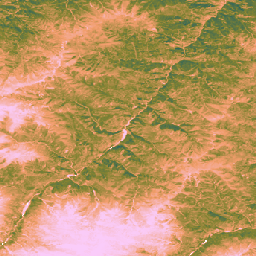
এই ডেটাসেটটি 2000 থেকে 30-মি স্থানিক রেজোলিউশনে বৈশ্বিক আনক্যালিব্রেটেড EO-ভিত্তিক গ্রস প্রাইমারি প্রোডাক্টিভিটি প্রদান করে। ল্যান্ড অ্যান্ড কার্বন ল্যাব গ্লোবাল পাশ্চার ওয়াচ উদ্যোগ দ্বারা উত্পাদিত, বর্তমান ডেটাসেটটি 2000 সাল থেকে 30-মি স্থানিক রেজোলিউশনে বিশ্বব্যাপী গ্রস প্রাইমারি প্রোডাক্টিভিটি (GPP) মান প্রদান করে। GPP মানগুলি হালকা ব্যবহারের দক্ষতা (LUE) পদ্ধতির মাধ্যমে তৈরি করা হয়েছে, যেখানে GLAD Landsat ARD (সংগ্রহ-2) প্রতি দুই মাসে একত্রিত করা হয় ( Consoli et al., 2024 ) এবং 1-km MODIS তাপমাত্রা ডেটা এবং 1° CERES ফটোসিন্থেটিকভাবে সক্রিয় বিকিরণ (AR) এর সাথে মিলিত হয়।
ডেটাসেট নমনীয় রাখার জন্য, সর্বাধিক আলো ব্যবহারের দক্ষতা (LUEmax) 1 gC/m²/day/MJ-এ সেট করা হয়েছে সমস্ত ল্যান্ড কভারের জন্য, ব্যবহারকারীদের পরে নির্দিষ্ট ল্যান্ড কভার ম্যাপ বা আঞ্চলিক অবস্থা অনুযায়ী GPP মানগুলিকে ক্যালিব্রেট করার অনুমতি দেয়৷
দ্বি-মাসিক আনক্যালিব্রেটেড গ্রস প্রাইমারি প্রোডাক্টিভিটি (uGPP) মানগুলি ( OpenLandMap STAC এ উপলব্ধ) প্রতি বছর গড় করা হয় এবং বিশ্বব্যাপী বার্ষিক uGPP মানগুলি তৈরি করতে 365-দিনের সময় ধরে জমা হয়, যা gC/m²/বছরের এককে প্রকাশ করা হয়।
GEE অ্যাপ ব্যবহার করে গ্রাসল্যান্ড জিপিপি মানগুলি ফ্লাইতে গণনা করা হয়৷
সীমাবদ্ধতা:
ইনপুট ডেটা রেজোলিউশন অমিল : ডেটাসেটটি 30 মিটার রেজোলিউশনে সরবরাহ করা হয়েছে, তবে তাপমাত্রার জন্য মূল ইনপুট ভেরিয়েবলগুলি (MOD11A1) এবং আলোকসংশ্লেষকভাবে সক্রিয় বিকিরণ (CERES PAR) অনেক মোটা পণ্য (যথাক্রমে 1 কিমি এবং ~ 111 কিমি) থেকে নেওয়া হয়েছিল। এই তথ্যের ডাউনস্কেলিং অনিশ্চয়তা প্রবর্তন করতে পারে এবং উদ্ভিদের উৎপাদনশীলতাকে প্রভাবিত করে এমন সূক্ষ্ম-স্কেল মাইক্রোক্লাইমেটিক অবস্থা ক্যাপচার করতে পারে না।
ডেটা আর্টিফ্যাক্টস : ডেটাসেটে পরিচিত ভিজ্যুয়াল আর্টিফ্যাক্ট রয়েছে, যার মধ্যে কিছু এলাকায় উল্লম্ব স্ট্রাইপ ("স্ট্রাইপ ইফেক্ট") রয়েছে, যা ল্যান্ডস্যাট 7 সেন্সর (স্ক্যান লাইন সংশোধনকারী ব্যর্থতা) এবং অন্তর্নিহিত প্রতিফলন সংরক্ষণাগার তৈরি করতে ব্যবহৃত গ্যাপ-ফিলিং প্রক্রিয়ার সমস্যাগুলির ফলাফল ( আল 20, কনসোলি 2 )। এই নিদর্শনগুলি মেঘলা এবং তুষার কভার সময়কালে জিপিপি অনুমানের স্থানিক ধারাবাহিকতাকে ব্যাহত করতে পারে
টেম্পোরাল রেজোলিউশন : ডেটা দ্বিমাসিক অস্থায়ী রেজোলিউশনে উত্পাদিত হয়। এই সময়সীমাটি মূল বৃদ্ধির সময়কাল বা পরিবেশগত পরিবর্তনের জন্য একটি উদ্ভিদের দ্রুত প্রতিক্রিয়া (তীব্র বৃষ্টিপাত) ক্যাপচার করার জন্য যথেষ্ট নাও হতে পারে, যার ফলে উৎপাদনশীলতার শিখর এবং ঋতু পরিবর্তনের সঠিকভাবে ক্যাপচার করা কঠিন হয়ে পড়ে।
তৃণভূমি ক্রমাঙ্কন : MOD17 অ্যালগরিদমের উপর ভিত্তি করে সমস্ত বিশ্বব্যাপী তৃণভূমির জন্য একটি একক সর্বাধিক আলো ব্যবহারের দক্ষতা (LUEmax) প্যারামিটার (0.86 gC/m²/year/MJ) ব্যবহার করে তৃণভূমির GPP মানগুলি গণনা করা হয়। এই মান নির্দিষ্ট তৃণভূমির ধরন বা স্থানীয় অবস্থার জন্য অপ্টিমাইজ করা হয় না। ফলস্বরূপ, স্থল-ভিত্তিক ফ্লাক্স টাওয়ার পরিমাপের তুলনায় মডেলটি GPP-কে অবমূল্যায়ন করার প্রবণতা দেখায়।
তৃণভূমি মানচিত্রের নির্ভুলতার উপর নির্ভরতা : তৃণভূমির জিপিপি মানগুলির নির্ভুলতা অন্তর্নিহিত GPW তৃণভূমি মানচিত্রের নির্ভুলতার উপর নির্ভরশীল। উৎস মানচিত্রে ভূমি আবরণের কোনো ভুল শ্রেণিবিন্যাস (যেমন, ঝোপঝাড় বা শস্যভূমি তৃণভূমি হিসেবে চিহ্নিত) সেই স্থানগুলির জন্য GPP অনুমানে সংশ্লিষ্ট ত্রুটির দিকে পরিচালিত করবে।
আরও তথ্যের জন্য দেখুন Isik et. al, 2025 , Zenodo এবং Global Pasture Watch GitHub সাইট
ব্যান্ড
ব্যান্ড
| নাম | মিন | সর্বোচ্চ | পিক্সেল সাইজ | বর্ণনা |
|---|---|---|---|---|
gc_m2 | 0 | 4000 | 30 মিটার | প্রতি বর্গ মিটার প্রতি বছর গ্রাম কার্বন (gC/m²/বছর) |
ইমেজ বৈশিষ্ট্য
ইমেজ বৈশিষ্ট্য
| নাম | টাইপ | বর্ণনা |
|---|---|---|
| সংস্করণ | আইএনটি | পণ্য সংস্করণ |
ব্যবহারের শর্তাবলী
ব্যবহারের শর্তাবলী
উদ্ধৃতি
Isik, MS, Mesquita, V., Parente, L., & Consoli, D. (2025)। গ্লোবাল পাশ্চার ওয়াচ - গ্লোবাল আনক্যালিব্রেটেড ইও-ভিত্তিক জিপিপি এবং গ্রাসল্যান্ড জিপিপি ম্যাপের সোর্স কোড 30 মি. জেনোডো। [উৎস কোড]। জেনোডো ডোই:https://doi.org/10.5281/zenodo.15675358
Isik MS, Parente L, Consoli D, et al. (2025)। 30 মিটার স্থানিক রেজোলিউশনে (2000-2022), পিয়ারজে বৈশ্বিক তৃণভূমির জন্য হালকা ব্যবহারের দক্ষতা (LUE) ভিত্তিক দ্বিমাসিক মোট প্রাথমিক উত্পাদনশীলতা (GPP)। doi: https://doi.org/10.7717/peerj.19774
DOIs
আর্থ ইঞ্জিন দিয়ে অন্বেষণ করুন
কোড এডিটর (জাভাস্ক্রিপ্ট)
Map.setCenter(-49.265188, -16.602052, 4);

var ugppVis = {min: 0, max: 4000, palette: "faccfa,f19d6b,828232,226061,011959"}
var ugpp = ee.ImageCollection(
    "projects/global-pasture-watch/assets/ggpp-30m/v1/ugpp_m"
)

var ugpp2024 = ugpp.filterDate('2024-01-01', '2025-01-01').first();
Map.addLayer(ugpp2024, ugppVis, 'Uncalibrated GPP (2024)');

var ugpp2000 = ugpp.filterDate('2000-01-01', '2001-01-01').first();
Map.addLayer(ugpp2000, ugppVis, 'Uncalibrated GPP (2000)');