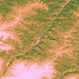
מערך הנתונים הזה מספק נתונים גלובליים לא מכוילים של פרודוקטיביות ראשונית ברוטו (GPP) שמבוססת על נתוני EO משנת 2000, ברזולוציה מרחבית של 30 מ'.
מערך הנתונים הנוכחי, שנוצר על ידי יוזמת Land & Carbon Lab Global Pasture Watch, מספק ערכים של פרודוקטיביות ראשונית ברוטו (GPP) ברחבי העולם ברזולוציה מרחבית של 30 מ' משנת 2000 ואילך.
ערכי ה-GPP מחושבים באמצעות גישה של יעילות שימוש באור (LUE),
שבה נתוני GLAD Landsat ARD (אוסף 2) נצברים כל חודשיים
(Consoli et al., 2024) ושולבו עם נתוני טמפרטורה של MODIS ברזולוציה של קילומטר אחד ועם קרינה פוטוסינתטית פעילה (PAR) של CERES ברזולוציה של מעלה אחת.
כדי לשמור על גמישות של מערך הנתונים, היעילות המקסימלית של השימוש באור (LUEmax) מוגדרת ל-1 gC/m²/day/MJ עבור כל סוגי כיסוי הקרקע, וכך המשתמשים יכולים לכייל את ערכי ה-GPP בהתאם למפות ספציפיות של כיסוי הקרקע או לתנאים אזוריים.
ערכי הפריון הראשוני הגולמי (GPP) הלא מכויל (uGPP) הדו-חודשיים (שזמינים ב-OpenLandMap STAC) מחושבים כממוצע לפי כל שנה ומצטברים על פני התקופה המלאה של 365 ימים כדי ליצור ערכי uGPP שנתיים גלובליים, שמבוטאים ביחידות של gC/m²/year.
ערכי Grassland GPP מחושבים תוך כדי תנועה באמצעות GEE App.
מגבלות:
אי התאמה ברזולוציה של נתוני הקלט: מערך הנתונים מסופק ברזולוציה של 30 מ', אבל משתני הקלט העיקריים של הטמפרטורה (MOD11A1) ושל קרינה פעילה פוטוסינתטית (CERES PAR) נגזרו ממוצרים גסים בהרבה (1 ק"מ ו-~111 ק"מ, בהתאמה).
הצגת המידע הזה בקנה מידה קטן יותר עלולה להוביל לחוסר ודאות, והיא לא תמיד משקפת את התנאים המיקרו-אקלימיים בקנה מידה קטן שמשפיעים על הפרודוקטיביות של הצמחים.
ארטיפקטים של נתונים: מערך הנתונים מכיל ארטיפקטים ויזואליים מוכרים, כולל פסים אנכיים ("אפקט הפסים") באזורים מסוימים, שהם תוצאה של בעיות בחיישן Landsat 7 (כשל בתיקון קו הסריקה) ובתהליך מילוי הפערים ששימש ליצירת ארכיון ההחזרות הבסיסי (Consoli et al., 2024). הארטיפקטים האלה עלולים לשבש את הרציפות המרחבית של הערכות ה-GPP במהלך תקופות של כיסוי עננים ושלג
רזולוציה זמנית: הנתונים נוצרים ברזולוציה זמנית של פעמיים בחודש. יכול להיות שפרק הזמן הזה לא מספיק כדי לתעד תקופות צמיחה חשובות או תגובות מהירות של צמח (גשם חזק) לשינויים סביבתיים, ולכן קשה לתעד במדויק את שיאי הפרודוקטיביות ואת השינויים העונתיים.
כיול של שטחי עשב: ערכי ה-GPP של שטחי עשב מחושבים באמצעות פרמטר יחיד של יעילות מקסימלית של ניצול אור (LUEmax) (0.86 gC/m²/year/MJ) לכל שטחי העשב בעולם, על סמך אלגוריתם MOD17. הערך הזה לא מותאם לסוגים ספציפיים של שטחי עשב או לתנאים מקומיים. כתוצאה מכך, המודל מראה נטייה להערכת חסר של GPP בהשוואה למדידות של מגדל שטף קרקעי.
תלות ברמת הדיוק של מפות שטחי העשב: רמת הדיוק של ערכי ה-GPP של שטחי העשב תלויה ברמת הדיוק של מפות שטחי העשב של GPW שמשמשות כבסיס.
כל סיווג שגוי של כיסוי הקרקע במפות המקור (למשל, אם שטחי שיחים או שטחים חקלאיים מזוהים כשטחי עשב) יוביל לשגיאות תואמות בהערכות של GPP עבור המיקומים האלה.
Isik, M. S., Mesquita, V., Parente, L., & Consoli, D. (2025).
Global Pasture Watch – קוד המקור של מפות GPP ו-Grassland GPP הגלובליות הלא מכוילות שמבוססות על נתוני EO ברזולוציה של 30 מ'. Zenodo.
[Source code]. Zenodo
doi:https://doi.org/10.5281/zenodo.15675358
Isik MS, Parente L, Consoli D, et al. (2025).
Light use efficiency (LUE) based bimonthly gross primary
productivity (GPP) for global grasslands at 30 m spatial
resolution (2000–2022), PeerJ.
doi: https://doi.org/10.7717/peerj.19774
מערך הנתונים הזה מספק נתונים גלובליים לא מכוילים של פרודוקטיביות ראשונית ברוטו שמבוססים על נתוני EO משנת 2000, ברזולוציה מרחבית של 30 מטר. מערך הנתונים הנוכחי, שנוצר על ידי יוזמת Land & Carbon Lab Global Pasture Watch, מספק ערכים של פרודוקטיביות ראשונית ברוטו (GPP) ברחבי העולם ברזולוציה מרחבית של 30 מ' משנת 2000 ואילך. הערכים של GPP מחושבים באמצעות שימוש קל …
[null,null,[],[],[],null,["# GPW Annual uncalibrated Gross Primary Productivity (uGPP) v1\n\ninfo\n\n\nThis dataset is part of a Publisher Catalog, and not managed by Google Earth Engine.\n\nContact [Land \\& Carbon Lab](https://landcarbonlab.org/subscribe)\n\nfor bugs or [view more datasets](https://developers.google.com/earth-engine/datasets/publisher/global-pasture-watch)\nfrom the Global Pasture Watch Catalog. [Learn more about Publisher datasets](/earth-engine/datasets/publisher). \n[](https://landcarbonlab.org/data/global-grassland-and-livestock-monitoring) \n\nCatalog Owner\n: Global Pasture Watch\n\nDataset Availability\n: 2000-01-01T00:00:00Z--2024-01-01T00:00:00Z\n\nDataset Provider\n:\n\n\n [Land and Carbon Lab Global Pasture Watch](https://landcarbonlab.org/data/global-grassland-and-livestock-monitoring)\n\nContact\n: [Land \\& Carbon Lab](https://landcarbonlab.org/subscribe)\n\nCadence\n: 1 Year\n\nTags\n:\n[global](/earth-engine/datasets/tags/global) [global-pasture-watch](/earth-engine/datasets/tags/global-pasture-watch) [land](/earth-engine/datasets/tags/land) [landcover](/earth-engine/datasets/tags/landcover) [landuse](/earth-engine/datasets/tags/landuse) [plant-productivity](/earth-engine/datasets/tags/plant-productivity) [publisher-dataset](/earth-engine/datasets/tags/publisher-dataset) [vegetation](/earth-engine/datasets/tags/vegetation) \n\n#### Description\n\nThis dataset provides global uncalibrated EO-based Gross Primary Productivity\nfrom 2000 at 30-m spatial resolution.\nProduced by Land \\& Carbon Lab Global Pasture Watch initiative, the current dataset provides\nGross Primary Productivity (GPP) values globally at 30-m spatial resolution from 2000 onwards.\nGPP values are modeled via a **light use efficiency (LUE)** approach,\nwhere [**GLAD Landsat ARD** (collection-2)](https://glad.umd.edu/ard/home) are aggregated every two months\n([Consoli et al., 2024](https://peerj.com/articles/18585/)) and combined with 1-km **MODIS\ntemperature** data and 1° **CERES Photosynthetically Active Radiation** (PAR).\n\nTo keep the dataset flexible, the maximum light use efficiency (LUEmax) is set to 1 gC/m²/day/MJ\nfor **all land cover types**, allowing the users to later calibrate the\nGPP values according to specific land cover maps or regional conditions.\n\n**Bi-monthly uncalibrated Gross Primary Productivity (uGPP)** values (available in [OpenLandMap STAC](https://stac.openlandmap.org/gpw_ugpp.daily-30m/collection.json)) are averaged by each year and accumulated over the full 365-day period to produce\nglobal annual uGPP values, expressed in units of gC/m²/year.\n\n**Grassland GPP** values are computed on-the-fly using [GEE App](https://global-pasture-watch.projects.earthengine.app/view/ggpp-30m).\n\n**Limitations:**\n\n- **Input data resolution mismatch**: The dataset is provided at 30 m resolution, but key input variables for temperature (MOD11A1)\n and photosynthetically active radiation (CERES PAR) were derived from much coarser products (1 km and \\~111 km, respectively).\n The downscaling of this information can introduce uncertainty and may not capture fine-scale microclimatic conditions affecting plant productivity.\n\n- **Data artifacts** : The dataset contains known visual artifacts, including vertical stripes (\"stripe effect\") in some areas, which are a result\n of issues with the Landsat 7 sensor (Scan Line Corrector failure) and the subsequent gap-filling process used to create the underlying\n reflectance archive ([Consoli et al., 2024](https://peerj.com/articles/18585/)). These artifacts can disrupt the spatial continuity\n of GPP estimates during cloudy and snow cover periods\n\n- **Temporal resolution**: The data is produced at a bimonthly temporal resolution. This timeframe may not be sufficient\n to capture key growth periods or a plant's rapid responses (intense rainfall) to environmental changes, making\n it difficult to accurately capture productivity peaks and seasonal variation.\n\n- **Grassland calibration**: Grassland GPP values are calculated using a single maximum light use efficiency (LUEmax)\n parameter (0.86 gC/m²/year/MJ) for all global grasslands, based on the MOD17 algorithm. This value is not optimized\n for specific grassland types or local conditions. As a result, the model shows a tendency to underestimate GPP when\n compared to ground-based flux tower measurements.\n\n- **Dependence on grassland maps accuracy** : The accuracy of the grassland GPP values is contingent on the accuracy of the\n underlying [GPW grassland maps](https://developers.google.com/earth-engine/datasets/catalog/projects_global-pasture-watch_assets_ggc-30m_v1_grassland_c).\n Any misclassification of land cover in the source maps (e.g., shrublands or croplands identified as grassland) will\n lead to corresponding errors in the GPP estimates for those locations.\n\n**For more information see [Isik et. al, 2025](https://doi.org/10.7717/peerj.19774),\n[Zenodo](https://doi.org/10.5281/zenodo.15675358) and\n[Global Pasture Watch GitHub site](https://github.com/wri/global-pasture-watch)**\n\n### Bands\n\n**Bands**\n\n| Name | Min | Max | Pixel Size | Description |\n|---------|-----|------|------------|--------------------------------------------------------|\n| `gc_m2` | 0 | 4000 | 30 meters | Grams of carbon per square meter per year (gC/m²/year) |\n\n### Image Properties\n\n**Image Properties**\n\n| Name | Type | Description |\n|---------|------|-----------------|\n| version | INT | Product version |\n\n### Terms of Use\n\n**Terms of Use**\n\n[CC-BY-4.0](https://spdx.org/licenses/CC-BY-4.0.html)\n\n### Citations\n\nCitations:\n\n- Isik, M. S., Mesquita, V., Parente, L., \\& Consoli, D. (2025).\n Global Pasture Watch - Source Code of the Global Uncalibrated EO-based GPP and\n Grassland GPP Maps at 30m. Zenodo.\n \\[Source code\\]. Zenodo\n [doi:https://doi.org/10.5281/zenodo.15675358](https://doi.org/10.5281/zenodo.15675358)\n- Isik MS, Parente L, Consoli D, et al. (2025).\n Light use efficiency (LUE) based bimonthly gross primary\n productivity (GPP) for global grasslands at 30 m spatial\n resolution (2000--2022), PeerJ.\n [doi: https://doi.org/10.7717/peerj.19774](https://doi.org/10.7717/peerj.19774)\n\n### DOIs\n\n- \u003chttps://doi.org/10.5281/zenodo.13890401\u003e\n- \u003chttps://doi.org/10.7717/peerj.19774\u003e\n\n### Explore with Earth Engine\n\n| **Important:** Earth Engine is a platform for petabyte-scale scientific analysis and visualization of geospatial datasets, both for public benefit and for business and government users. Earth Engine is free to use for research, education, and nonprofit use. To get started, please [register for Earth Engine access.](https://console.cloud.google.com/earth-engine)\n\n### Code Editor (JavaScript)\n\n```javascript\nMap.setCenter(-49.265188, -16.602052, 4);\n\nvar ugppVis = {min: 0, max: 4000, palette: \"faccfa,f19d6b,828232,226061,011959\"}\nvar ugpp = ee.ImageCollection(\n \"projects/global-pasture-watch/assets/ggpp-30m/v1/ugpp_m\"\n)\n\nvar ugpp2024 = ugpp.filterDate('2024-01-01', '2025-01-01').first();\nMap.addLayer(ugpp2024, ugppVis, 'Uncalibrated GPP (2024)');\n\nvar ugpp2000 = ugpp.filterDate('2000-01-01', '2001-01-01').first();\nMap.addLayer(ugpp2000, ugppVis, 'Uncalibrated GPP (2000)');\n```\n[Open in Code Editor](https://code.earthengine.google.com/?scriptPath=Examples:Datasets/global-pasture-watch/projects_global-pasture-watch_assets_ggpp-30m_v1_ugpp_m) \n[GPW Annual uncalibrated Gross Primary Productivity (uGPP) v1](/earth-engine/datasets/catalog/projects_global-pasture-watch_assets_ggpp-30m_v1_ugpp_m) \nThis dataset provides global uncalibrated EO-based Gross Primary Productivity from 2000 at 30-m spatial resolution. Produced by Land \\& Carbon Lab Global Pasture Watch initiative, the current dataset provides Gross Primary Productivity (GPP) values globally at 30-m spatial resolution from 2000 onwards. GPP values are modeled via a light use ... \nprojects/global-pasture-watch/assets/ggpp-30m/v1/ugpp_m, global,global-pasture-watch,land,landcover,landuse,plant-productivity,publisher-dataset,vegetation \n2000-01-01T00:00:00Z/2024-01-01T00:00:00Z \n-90 -180 90 180 \nGoogle Earth Engine \nhttps://developers.google.com/earth-engine/datasets\n\n- [https://doi.org/10.7717/peerj.19774](https://doi.org/https://landcarbonlab.org/data/global-grassland-and-livestock-monitoring)\n- [https://doi.org/10.7717/peerj.19774](https://doi.org/https://developers.google.com/earth-engine/datasets/catalog/projects_global-pasture-watch_assets_ggpp-30m_v1_ugpp_m)"]]