- Chủ sở hữu danh mục
- Dự án Bản đồ bệnh sốt rét
- Phạm vi cung cấp tập dữ liệu
- 2001-02-01T00:00:00Z–2024-12-26T00:00:00Z
- Nhà cung cấp tập dữ liệu
- Dự án Bản đồ bệnh sốt rét
- Thông tin liên hệ
- Dự án Bản đồ bệnh sốt rét
- Tần suất
- 8 ngày
- Thẻ
Mô tả
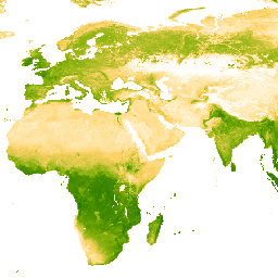
Tập dữ liệu cơ bản cho sản phẩm Chỉ số thực vật nâng cao (EVI) này là hình ảnh được điều chỉnh BRDF của MODIS (MCD43B4), được lấp đầy khoảng trống bằng phương pháp được nêu trong Weiss và cộng sự (2014) để loại bỏ dữ liệu bị thiếu do các yếu tố như độ che phủ của đám mây. Sau khi điền vào chỗ trống, dữ liệu được cắt thành các ngưỡng [0, 1] để đảm bảo các giá trị hợp lệ.
Sau đó, các đầu ra 8 ngày ~1 km được lấp đầy khoảng trống sẽ được tổng hợp theo thời gian để tạo ra các sản phẩm hằng tháng và hằng năm.
Băng tần
Kích thước pixel
5.000 mét
Băng tần
| Tên | Phút | Tối đa | Kích thước pixel | Mô tả |
|---|---|---|---|---|
Mean |
0* | 1* | mét | Giá trị trung bình của Chỉ số thực vật nâng cao cho mỗi pixel được tổng hợp. |
Điều khoản sử dụng
Điều khoản sử dụng
Trích dẫn
Weiss, D.J., P.M. Atkinson, S. Bhatt, B. Mappin, S.I. Hay & P.W. Gething (2014) An effective approach for gap-filling continental scale remotely sensed time-series. ISPRS Journal of Photogrammetry and Remote Sensing, 98, 106-118. doi:10.1016/j.isprsjprs.2014.10.001
Khám phá bằng Earth Engine
Trình soạn thảo mã (JavaScript)
var dataset = ee.ImageCollection('projects/malariaatlasproject/assets/EVI_v061/1km/8-Daily')
                  .filter(ee.Filter.date('2022-01-01', '2022-04-01'));
var means = dataset.select('Mean');
var visParams = {
  min: 0.0,
  max: 1.0,
  palette: ['ffffff','fcd163','99b718','66a000','3e8601','207401','056201','004c00','011301'],
};
Map.setCenter(0, 0, 2);
Map.addLayer(means, visParams, '8-Daily EVI: Malaria Atlas Project Gap-Filled Enhanced Vegetation Index');