- Właściciel katalogu
- The Malaria Atlas Project
- Dostępność zbioru danych
- 2001-02-01T00:00:00Z–2024-01-01T00:00:00Z
- Dostawca zbioru danych
- The Malaria Atlas Project
- Kontakt
- The Malaria Atlas Project
- Cykl
- 1 rok
- Tagi
Opis
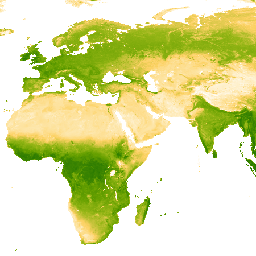
Podstawowym zbiorem danych dla tego produktu Enhanced Vegetation Index (EVI) są obrazy MODIS skorygowane pod kątem BRDF (MCD43B4), w których uzupełniono luki przy użyciu metody opisanej w artykule Weiss i in. (2014) w celu wyeliminowania brakujących danych spowodowanych takimi czynnikami jak zachmurzenie. Po uzupełnieniu luk dane zostały przycięte do wartości progowych [0, 1], aby zapewnić prawidłowe wartości.
Wypełnione luki w 8-dniowych danych o rozdzielczości ok. 1 km są następnie agregowane w czasie, aby uzyskać produkty miesięczne i roczne.
Pasma
Rozmiar piksela
5000 metrów
Pasma
| Nazwa | Minimum | Maks. | Rozmiar piksela | Opis |
|---|---|---|---|---|
Mean |
0* | 1* | metry | Średnia wartość ulepszonego wskaźnika wegetacji dla każdego zagregowanego piksela. |
Warunki korzystania z usługi
Warunki korzystania z usługi
Cytaty
Weiss, D.J., P.M. Atkinson, S. Bhatt, B. Mappin, S.I. Hay & P.W. Gething (2014) An effective approach for gap-filling continental scale remotely sensed time-series. ISPRS Journal of Photogrammetry and Remote Sensing, 98, 106–118. doi:10.1016/j.isprsjprs.2014.10.001
Odkrywanie za pomocą Earth Engine
Edytor kodu (JavaScript)
var dataset = ee.ImageCollection('projects/malariaatlasproject/assets/EVI_v061/1km/Annual')
                  .filter(ee.Filter.date('2018-01-01', '2023-01-01'));
var means = dataset.select('Mean');
var visParams = {
  min: 0.0,
  max: 1.0,
  palette: ['ffffff','fcd163','99b718','66a000','3e8601','207401','056201','004c00','011301'],
};
Map.setCenter(0, 0, 2);
Map.addLayer(means, visParams, 'Annual EVI: Malaria Atlas Project Gap-Filled Enhanced Vegetation Index');