- בעלי הקטלוג
- Nature Trace
- זמינות מערך הנתונים
- 2018-01-01T00:00:00Z–2020-12-31T23:59:59Z
- ספק מערך נתונים
- תגים
תיאור
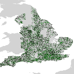
מערך הנתונים Farmscapes 2020 מספק מפות הסתברות ברזולוציה גבוהה (25 ס"מ) לשלושה מאפיינים מרכזיים של שטחים חקלאיים באנגליה: גדרות חיות, שטחי יער וקירות אבן. מערך הנתונים הזה פותח בשיתוף עם Oxford Leverhulme Centre for Nature Recovery כדי לשמש כבסיס לאפליקציות שכוללות שיקום נוף, מעקב אחר מגוון ביולוגי וניתוח של קישוריות אקולוגית.
מערך הנתונים נוצר על ידי הפעלת מודל טרנספורמר של ראייה על פסיפס של צילומי אוויר ברזולוציה גבוהה, שאומן באמצעות קורפוס גדול של תוויות עם הערות של בני אדם. הפלט מורכב משלוש שכבות הסתברות נפרדות, אחת לכל מחלקת תכונות. הפורמט ההסתברותי הזה מאפשר למשתמשים להחיל ספי התאמה אישית כדי ליצור מפות תכונות בינאריות שמותאמות לדרישות הניתוח הספציפיות שלהם.
מגבלות
- היקף גיאוגרפי: הביצועים של המודל יורדים בסביבות עירוניות צפופות ובאזורים הרריים, שלא יוצגו מספיק בנתוני האימון שהתמקדו בעיקר בנופים כפריים.
- דיוק זמני: צילומי המקור בוצעו בין 2018 ל-2020. לכן, מערך הנתונים לא כולל שינויים בנוף שהתרחשו מאז התקופה הזו.
- ביצועים ספציפיים לכיתה: הכיתה של קיר האבן מציגה דיוק נמוך יותר בהשוואה לכיתות של יערות וגדרות חיות, כתוצאה מחוסר איזון משמעותי בין הכיתות בנתוני האימון.
מערך נתונים של אירופה
בנוסף למערך הנתונים הראשי של אנגליה, נוצרה גרסה ראשונית בקנה מידה אירופי. מערך הנתונים הזה לא עבר את אותו אימות כמותי ולכן הוא נחשב לניסיוני. אפשר לבקש גישה למערך הנתונים הזה באמצעות הטופס הזה.
תחום תדרים
גודל הפיקסל
0.25 מטרים
תחום תדרים
| שם | מינימום | מקסימום | קנה מידה | גודל הפיקסל | תיאור |
|---|---|---|---|---|---|
B0 |
0 | 250 | 0.004 | מטרים | הסתברות לגידור חי (בסולם של [0-250]). |
B1 |
0 | 250 | 0.004 | מטרים | הסתברות לקיר אבן (בסולם של [0-250]). |
B2 |
0 | 250 | 0.004 | מטרים | ההסתברות לזיהוי אזור מיוער (בסולם של [0-250]). |
תנאים והגבלות
תנאים והגבלות
הרישיון לשימוש במערך הנתונים הזה הוא CC-BY-NC 4.0, ונדרש ייחוס מהסוג הבא: "מערך הנתונים הזה נוצר על ידי Google".
ציטוטים ביבליוגרפיים
מיכלאנג'לו קונסרבה (Michelangelo Conserva), אלכס וילסון (Alex Wilson), שרלוט סטנטון (Charlotte Stanton), וישאל באטצ'ו (Vishal Batchu), וארון גולשאן (Varun Gulshan), "מיפוי נופים חקלאיים מחישה מרחוק" (בבדיקה). doi:10.48550/arXiv.2506.13993,
סיור באמצעות Earth Engine
עורך הקוד (JavaScript)
var farmscapes =
    ee.ImageCollection('projects/nature-trace/assets/farmscapes/england_v1_0')
        .mosaic();
Map.addLayer(farmscapes, {}, 'Raw probs', false);

var stone_wall = farmscapes.select(['B1']);
stone_wall = stone_wall.updateMask(stone_wall.gt(250 / 4));
Map.addLayer(
    stone_wall, {palette: ['FFFFFF', '00FFFF'], min: 0, max: 250},
    'Stone wall');

var hedgerow = farmscapes.select(['B0']);
hedgerow = hedgerow.updateMask(hedgerow.gt(250 / 4));
Map.addLayer(
    hedgerow, {palette: ['FFFFFF', 'c71585'], min: 0, max: 250}, 'Hedgerow');

var woodland = farmscapes.select(['B2']);
woodland = woodland.updateMask(woodland.gt(250 / 4));
Map.addLayer(
    woodland, {palette: ['FFFFFF', '06402B'], min: 0, max: 250}, 'Woodland');

var lon = -1.43;
var lat = 52.973;
Map.setCenter(lon, lat, 15);