আইপিসিসি-র ভূপৃষ্ঠস্থ জীবভর স্তর ১ অনুমানের জন্য বৈশ্বিক ২০২০ বন শ্রেণিবিন্যাস, সংস্করণ ১ 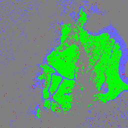
এই ডেটাসেটটি প্রায় ৩০ মিটার রেজোলিউশনে ২০২০ সালের অবস্থা/পরিস্থিতি অনুসারে চিহ্নিত বিশ্বব্যাপী বনের শ্রেণীগুলো প্রদান করে। এই ডেটা ২০০৬ সালের আইপিসিসি (IPCC) জাতীয় গ্রিনহাউস গ্যাস নির্দেশিকার ২০১৯ সালের পরিমার্জন অনুসারে প্রাকৃতিক বনের ভূপৃষ্ঠস্থ শুষ্ক কাষ্ঠল বায়োমাস ঘনত্বের (AGBD) জন্য টিয়ার ১ (Tier 1) অনুমান তৈরিতে সহায়তা করে। ভূপৃষ্ঠের উপরের জৈববস্তু কার্বন শ্রেণিবিন্যাস বন বন-জৈববস্তু বৈশ্বিক ভূপৃষ্ঠস্থ এবং ভূগর্ভস্থ জীবভর কার্বন ঘনত্বের মানচিত্র 
এই ডেটাসেটটি ৩০০-মিটার স্থানিক রেজোলিউশনে ২০১০ সালের জন্য ভূপৃষ্ঠের উপরে এবং নিচে থাকা বায়োমাস কার্বন ঘনত্বের সময়গতভাবে সামঞ্জস্যপূর্ণ ও সমন্বিত বৈশ্বিক মানচিত্র প্রদান করে। ভূপৃষ্ঠের উপরের বায়োমাস মানচিত্রটি কাষ্ঠল, তৃণভূমি, শস্যভূমি এবং তুন্দ্রা অঞ্চলের বায়োমাসের ভূমি-আচ্ছাদন-নির্দিষ্ট, দূরসংবেদী মানচিত্রকে একীভূত করে। ইনপুট মানচিত্রগুলো ছিল… ভূপৃষ্ঠের উপরের জৈববস্তু কার্বন ঘনত্ব বন বন-জৈববস্তু ইউএসএফএস ট্রি ম্যাপ ভি২০২০ 
এই পণ্যটি ট্রি ম্যাপ ডেটা স্যুটের একটি অংশ। এটি ২০২০ সালে মার্কিন যুক্তরাষ্ট্রের সমগ্র বনভূমি জুড়ে জীবিত ও মৃত গাছের সংখ্যা, বায়োমাস এবং কার্বন সহ বনের বৈশিষ্ট্য সম্পর্কে বিস্তারিত স্থানিক তথ্য প্রদান করে। ট্রি ম্যাপ ভি২০২০-এ ২২-ব্যান্ডের ৩০ x ৩০ মিটার ডেটা রয়েছে… ভূপৃষ্ঠের উপরের জৈববস্তু কার্বন জলবায়ু পরিবর্তন কোনাস বন ইউএসএফএস ট্রি ম্যাপ ভি২০২২ 
এই পণ্যটি ট্রি ম্যাপ ডেটা স্যুটের একটি অংশ। এটি ২০২২ সালে মার্কিন যুক্তরাষ্ট্রের সমগ্র বনভূমি জুড়ে জীবিত ও মৃত গাছের সংখ্যা, বায়োমাস এবং কার্বন সহ বনের বৈশিষ্ট্য সম্পর্কে বিস্তারিত স্থানিক তথ্য প্রদান করে। ট্রি ম্যাপ ভি২০২২-এ ২২-ব্যান্ডের ৩০ x ৩০ মিটার ডেটা রয়েছে… ভূপৃষ্ঠের উপরের জৈববস্তু কার্বন জলবায়ু পরিবর্তন কোনাস বন WHRC প্যানট্রপিক্যাল জাতীয় স্তরের কার্বন মজুত ডেটাসেট 
ক্রান্তীয় দেশগুলোর জন্য ৫০০ মিটার উচ্চতায় ভূপৃষ্ঠের উপরের জীবন্ত কাষ্ঠল জৈববস্তুর ঘনত্বের একটি জাতীয় পর্যায়ের মানচিত্র। এই ডেটাসেটটি একই স্থানে করা মাঠপর্যায়ের পরিমাপ, LiDAR পর্যবেক্ষণ এবং মডারেট রেজোলিউশন ইমেজিং স্পেকট্রোরাডিওমিটার (MODIS) থেকে রেকর্ড করা চিত্রাবলীর সমন্বয়ে সংকলিত হয়েছে। ভূপৃষ্ঠস্থ জৈববস্তু কার্বন বন-জৈববস্তু ভূ-ভৌত ইউএমডি
Datasets tagged aboveground in Earth Engine
[null,null,[],[],[]]