কোত দিভোয়ার বিএনইটিডি ২০২০ ভূমি আচ্ছাদন মানচিত্র 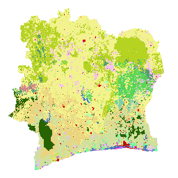
ইউরোপীয় ইউনিয়নের প্রযুক্তিগত ও আর্থিক সহায়তায় আইভরিয়ান সরকার একটি জাতীয় প্রতিষ্ঠান, সেন্টার ফর জিওগ্রাফিক ইনফরমেশন অ্যান্ড ডিজিটাল ফ্রম দ্য ন্যাশনাল স্টাডি অফিস টেকনিকস অ্যান্ড ডেভেলপমেন্ট (BNETD-CIGN)-এর মাধ্যমে কোত দিভোয়ার BNETD ২০২০ ভূমি আচ্ছাদন মানচিত্রটি তৈরি করেছে। এর কার্যপ্রণালী… শ্রেণীবিভাগ বন উজাড় বনভূমি ভূমি আচ্ছাদন ভূমি ব্যবহার-ভূমি আচ্ছাদন আইপিসিসি-র ভূপৃষ্ঠস্থ জীবভর স্তর ১ অনুমানের জন্য বৈশ্বিক ২০২০ বন শ্রেণিবিন্যাস, সংস্করণ ১ 
এই ডেটাসেটটি প্রায় ৩০ মিটার রেজোলিউশনে ২০২০ সালের অবস্থা/পরিস্থিতি অনুসারে চিহ্নিত বিশ্বব্যাপী বনের শ্রেণীগুলো প্রদান করে। এই ডেটা ২০০৬ সালের আইপিসিসি (IPCC) জাতীয় গ্রিনহাউস গ্যাস নির্দেশিকার ২০১৯ সালের পরিমার্জন অনুসারে প্রাকৃতিক বনের ভূপৃষ্ঠস্থ শুষ্ক কাষ্ঠল বায়োমাস ঘনত্বের (AGBD) জন্য টিয়ার ১ (Tier 1) অনুমান তৈরিতে সহায়তা করে। ভূপৃষ্ঠের উপরের জৈববস্তু কার্বন শ্রেণিবিন্যাস বন বন-জৈববস্তু গ্লোবাল ৩-শ্রেণির পালসার-২/পালসার বন/অ-বন মানচিত্র 
২০১৭-২০২০ সালের জন্য ৪টি ক্লাস সহ এই ডেটাসেটের একটি নতুন সংস্করণ JAXA/ALOS/PALSAR/YEARLY/FNF4-এ পাওয়া যাবে। বৈশ্বিক ২৫ মিটার রেজোলিউশনের PALSAR-2/PALSAR SAR মোজাইকে SAR চিত্রকে (ব্যাকস্ক্যাটারিং সহগ) শ্রেণিবদ্ধ করে বৈশ্বিক বন/অরণ্যহীন মানচিত্র (FNF) তৈরি করা হয়, যাতে শক্তিশালী এবং কম ব্যাকস্ক্যাটার পিক্সেলগুলো… alos alos2 শ্রেণীবিভাগ eroc বন বন-জৈবভর গ্লোবাল ৪-শ্রেণির পালসার-২/পালসার বন/অ-বন মানচিত্র 
বৈশ্বিক ২৫ মিটার রেজোলিউশনের PALSAR-2/PALSAR SAR মোজাইকের SAR চিত্রকে (ব্যাকস্ক্যাটারিং সহগ) শ্রেণিবদ্ধ করার মাধ্যমে বৈশ্বিক বন/অ-বন মানচিত্র (FNF) তৈরি করা হয়, যাতে শক্তিশালী এবং কম ব্যাকস্ক্যাটার পিক্সেলগুলিকে যথাক্রমে "বন" এবং "অ-বন" হিসাবে চিহ্নিত করা হয়। এখানে, "বন" বলতে প্রাকৃতিক বনকে বোঝানো হয়েছে যার … alos alos2 শ্রেণীবিভাগ eroc বন বন-জৈবভর
Datasets tagged classification in Earth Engine
[null,null,[],[],[]]