-
2000 Grönland Mozaik - Grönland Buz Haritası Projesi (GIMP)

Bu veri kümesi, 1999-2002 yılları arasındaki Landsat 7 ETM+ ve RADARSAT-1 SAR görüntülerinden elde edilen, Grönland buz tabakasının 15 metre çözünürlüklü eksiksiz bir görüntü mozağini sunar. Bu yöntemler arasında görüntü bulutu maskeleme, keskinleştirme, görüntü örnekleme ve yeniden boyutlandırma gibi tekniklerin bir kombinasyonu yer alır. arctic gimp greenland imagery nasa polar -
ArcticDEM Mosaic V4.1
ArcticDEM, optik stereo görüntüleme, yüksek performanslı bilgi işlem ve açık kaynaklı fotogrametri yazılımı kullanarak Arktik'in yüksek çözünürlüklü ve yüksek kaliteli bir dijital yüzey modelini (DSM) otomatik olarak üretmek için National Geospatial-Intelligence Agency (NGA) ve National Science Foundation (NSF) tarafından başlatılan bir kamu-özel sektör girişimidir. Bitki örtüsü, ağaç gölgesi, binalar ve … arctic dem elevation-topography geophysical pgc umn -
ArcticDEM Şeritleri

ArcticDEM, optik stereo görüntüleme, yüksek performanslı bilgi işlem ve açık kaynaklı fotogrametri yazılımı kullanarak Arktik'in yüksek çözünürlüklü ve yüksek kaliteli bir dijital yüzey modelini (DSM) otomatik olarak üretmek için National Geospatial-Intelligence Agency (NGA) ve National Science Foundation (NSF) tarafından başlatılan bir kamu-özel sektör girişimidir. Bitki örtüsü, ağaç gölgesi, binalar ve … arctic dem elevation-topography geophysical pgc umn -
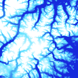
Grönland DEM - Greenland Mapping Project (GIMP)

Bu Dijital Yükseklik Modeli (DEM), yaklaşık 82,5°K'nın güneyindeki buz tabakası çevresi ve kenarı (yani denge çizgisi yüksekliğinin altı) için ASTER ve SPOT-5 DEM'lerinin bir kombinasyonundan ve buz tabakası iç kısmında ve en kuzeyde AVHRR fotoklinometrisinden (Scambos ve … arctic elevation-topography gimp greenland nasa polar -
Grönland Buz ve Okyanus Maskesi - Grönland Haritalandırma Projesi (GIMP)

Bu veri kümesi, Grönland buz tabakası için 15 metre çözünürlükte eksiksiz kara buzu ve okyanus sınıflandırma maskeleri sağlar. Buz örtüsü, USGS tarafından dağıtılan Landsat 7 Enhanced Thematic Mapper Plus (ETM+) cihazından alınan ortorektifiye edilmiş pankromatik (bant 8) görüntülerin bir kombinasyonu kullanılarak haritalandı ve … arctic cryosphere gimp greenland ice nasa -
MEaSUREs Greenland Ice Velocity: Selected Glacier Site Velocity Maps from Optical Images Version 2

NASA'nın Making Earth System Data Records for Use in Research Environments (MEaSUREs) programının bir parçası olan bu veri kümesi, seçilen buzul çıkış alanları için aylık ortalama hız haritalarından oluşur. Haritalar, Landsat tarafından elde edilen optik görüntü çiftleri arasındaki görünür özellikler izlenerek oluşturulur. arctic cryosphere gimp greenland ice nasa
Datasets tagged arctic in Earth Engine
[null,null,[],[],["The content details datasets from the Greenland Ice Mapping Project (GIMP) and ArcticDEM initiatives. GIMP provides a 15m resolution ice/ocean classification mask and a 2000 image mosaic of Greenland derived from Landsat 7 and RADARSAT-1. It also includes a digital elevation model (DEM) and mean monthly glacier velocity maps. ArcticDEM, a joint NGA/NSF project, offers high-resolution digital surface models (DSMs) of the Arctic, encompassing features like vegetation and buildings.\n"]]